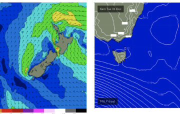
Huey will be not be offering much in the way of surf for the last days of 2024. The outlook is low energy with weak high pressure moving into the Tasman and no swells of any significance in the near or far swell windows.
Primary tabs
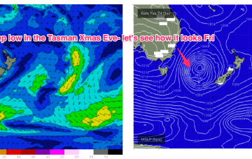
/reports/forecaster-notes/eastern-tasmania/2024/12/27/surf-becoming-tiny-over-the-weekend-and-close
freeride76
Friday, 27 December 2024
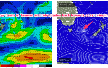
/reports/forecaster-notes/eastern-tasmania/2024/12/25/ne-windswell-boxing-day-and-fri-then-not-much
freeride76
Wednesday, 25 December 2024
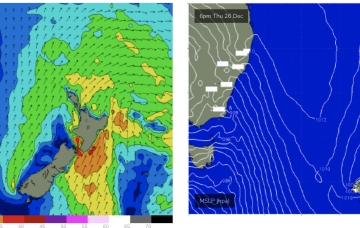
Elongated high pressure is moving into the Tasman with an approaching trough, front and cut-off low expected to tighten the pressure gradient leading to freshening N’lies from Boxing Day and some developing NE windswell.
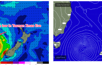
/reports/forecaster-notes/eastern-tasmania/2024/12/23/sizey-s-swell-xmas-eve-ne-windswell-developing
freeride76
Monday, 23 December 2024
In the short run, we’ll see a wintry type of pattern develop with strong SW winds tending S/SW-S as a low moves east of Tasmania.
/reports/forecaster-notes/eastern-tasmania/2024/12/20/fun-waves-over-the-weekend-dynamic-xmas-week
freeride76
Friday, 20 December 2024
O/night Sun into Mon we’ll see a low form off the Gippsland Coast and begin to deepen rapidly through the morning.
/reports/forecaster-notes/eastern-tasmania/2024/12/18/fun-blend-swells-ahead-dynamic-outlook-xmas
freeride76
Wednesday, 18 December 2024
A small spike in short range S swell will be reinforced by better quality SE-E/SE swells later this week.
/reports/forecaster-notes/eastern-tasmania/2024/12/16/sizey-ne-windswell-short-term-s-se-swells-the
freeride76
Monday, 16 December 2024
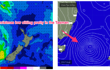
We’ll see some swell from this pattern, first from the initial short range S swell and then some better quality S/SE swell as the surface low retrogrades from near the South Island back into the Tasman.
/reports/forecaster-notes/eastern-tasmania/2024/12/13/sizey-ne-windswell-building-mon-tues-s-spike
freeride76
Friday, 13 December 2024
That sets up for a solid spike in NE windswell through Mon as high pressure moves NE and a trough approaches.

/reports/forecaster-notes/eastern-tasmania/2024/12/11/s-groundswell-short-term-sizey-ne-windswell-mon
freeride76
Wednesday, 11 December 2024
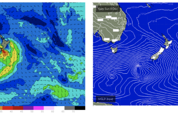
A deep low (962hPa) is currently well to the SW of Tasmania and tracking into the lower Tasman, although being shunted to the SE as it does so. We’ll see some S’ly groundswell from this source.

/reports/forecaster-notes/eastern-tasmania/2024/12/09/small-s-pulse-later-week-ne-windswell-early
freeride76
Monday, 9 December 2024
There is a deep low expected to scoot through the lower Tasman, weakening as it does so which may offer some flukey S swell at S swell magnets Thurs/Fri.

/reports/forecaster-notes/eastern-tasmania/2024/12/06/surf-becoming-very-tiny-next-week-while
freeride76
Friday, 6 December 2024
There’s really nothing of interest at all next week with surf remaining tiny right into next weekend.