Tricky week, better much more active from Sunday

Victorian forecast by Craig Brokensha (issued Monday March 31st)
Best Days: Thursday morning to the east, Sunday onwards into next week
Features of the Forecast (tl;dr)
- Mod-large SW groundswell filling in tomorrow, peaking through the day with mod-fresh E/SE winds, strengthening
- Easing swell Wed with light-mod E-E/SE winds ahead of fresh sea breezes
- Smaller Thu AM with variable tending fresh S/SW winds mid-AM
- Small-mod sized W/SW swell building Fri, peaking in the PM with SW winds (possibly W/NW early Surf Coast)
- Small-mod sized SW swell Sat with gusty W/SW-SW winds
- Large SW groundswell building Sun PM, peaking Mon/Tue under W/NW-W/SW winds
Recap
The window for a clean wave on the weekend was very limited with the pre-dawn session Saturday offering light winds to the east of Melbourne before a trough brought a strong onshore change.
This wind shifted E/SE-SE into yesterday, whipping up a stormy SE windswell across the Surf Coast while to the east options were limited to selected protected spots with a lift in mid-period swell.
Today winds are still strong from the S/SE-SE along with no real quality to be found. A larger SW groundswell is due later this afternoon and more so tomorrow, discussed below.
This week and weekend (Apr 1 - 6)
As touched on last week, we’ve got a strong groundswell due into later today but more so tomorrow, generated by a strong, elongated frontal progression swinging in from the Indian Ocean, generating fetches of gale to severe-gale W-W/NW winds.
The swell will have a couple of pulses, with a late increase due later today though tomorrow will see the bulk of the energy, peaking through the middle of the day to afternoon with 4-5ft+ sets likely on the Surf Coast magnets and 6ft to occasionally 8ft waves to the east.
Unfortunately E/SE winds are due tomorrow morning, moderate to fresh in nature and stronger into the afternoon, with Wednesday coming in a little cleaner as winds ease and tending more E-E/SE.

It won’t be perfect and the exposed beaches to the east are likely to be still too chunky with easing sets from 6ft+ or so, 4ft to the east.
Thursday is a tricky one as early variable winds freshen quickly from the S/SW thanks to an approaching trough. Early looks to be 2ft on the Surf Coast magnets with 3-4ft sets to the east.
The trough will actually spawn off a strong polar low that’s currently south-west of Western Australia, projecting north through today. A fetch of W/SW-SW gales will be generated through our western swell window, generating a small to moderate sized mid-period W/SW swell for Friday afternoon, coming in at 3ft+ on the Surf Coast magnets and 4-6ft to the east.
Unfortunately SW winds look to linger Friday in the wake of the trough on Thursday, with an outside chance of early W/NW winds on the Surf Coast but the swell will yet to be in.
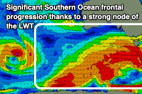
Into the weekend, a reinforcing mid-period SW swell to a similar size seen Friday is due, produced by a distant but strong polar storm on the backside of the low projecting towards Western Australia. Winds still look dicey and strong from the W/SW-SW as a much more significant and exciting Southern Ocean frontal progression develops south-west of us.
A strong node of the Long Wave Trough will bring with it a broad, strong Southern Ocean frontal progression, with multiple significant polar storms due to project up and into us from Friday evening through the weekend.
This looks to generate a large run of SW groundswell from Sunday afternoon through Tuesday next week along with favourable westerly winds. More on this Wednesday and Friday.
Comments
Damn this weekend is going to be pumping!!