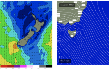
Back up again Thurs from the E-E/NE as winds feeding into the low strengthen before slipping behind NZ.
Primary tabs
/reports/forecaster-notes/eastern-tasmania/2025/07/07/some-quality-the-ene-week-low-drifts-towards-nz
freeride76
Monday, 7 July 2025
/reports/forecaster-notes/eastern-tasmania/2025/07/04/easing-swells-over-the-weekend-small-fun-pulses
freeride76
Friday, 4 July 2025
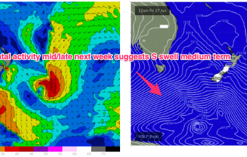
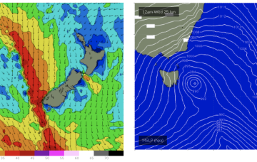
The trough is linked to a broad low which moves off the South Coast o/night Sun into Mon and does aim up some useful swell generating winds for NETas.
/reports/forecaster-notes/eastern-tasmania/2025/07/02/ecl-in-tasman-still-supplying-plenty-swell
freeride76
Wednesday, 2 July 2025
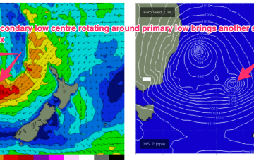
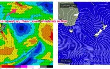
Gales to severe gales from the S through SE will generate another peak in size later today and through tomorrow from the secondary low slingshotting around the primary centre, well positioned in the Tasmanian swell window. Winds from the E-E/NE are also still active in the swell window.

/reports/forecaster-notes/eastern-tasmania/2025/06/30/solid-ene-swell-tas-ecl-sits-in-tasman-sea
freeride76
Monday, 30 June 2025
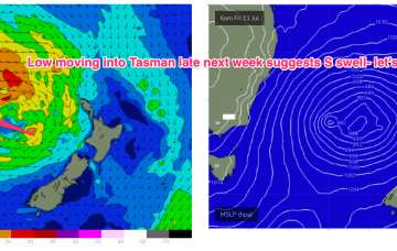
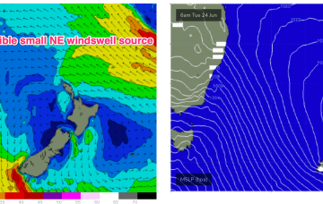
Winds on the south-east to north-east flanks of the low will be gale force E to E/NE infeeds, extending out into the Tasman and Southern Coral Sea, aimed at Central/Southern NSW and down to Tasmania.
/reports/forecaster-notes/eastern-tasmania/2025/06/27/ecl-next-week-brings-possibility-pumping-surf
freeride76
Friday, 27 June 2025
Through Mon both the coastal and Coral Sea troughs deepen with a strong and broad E/NE-NE infeed into a developing surface low (possibly some variant of ECL) late Mon o/night into Tues.

/reports/forecaster-notes/eastern-tasmania/2025/06/25/mix-s-swells-and-e-swells-ahead
freeride76
Wednesday, 25 June 2025
In the eastern swell window a massive high east of New Zealand and tropical depression in Tongan longitudes is reaching peak intensity and expected to send some meaningful E’ly groundswell towards the eastern seaboard and as far south as Tasmania, making landfall early next week.
/reports/forecaster-notes/eastern-tasmania/2025/06/23/sizey-s-swells-ahead-low-pushes-past-tasmania
freeride76
Monday, 23 June 2025
Despite the travel distance to Tasmania, we should see some quality long range E/NE swell from this source, with some size from the south this week as the front and low traverse the Tasman.
/reports/forecaster-notes/eastern-tasmania/2025/06/20/ne-windswell-followed-s-swells-next-week
freeride76
Friday, 20 June 2025
N’lies freshen Tues as the large low/front approaches, tending NW through the a’noon, even W/NW by close of play.
/reports/forecaster-notes/eastern-tasmania/2025/06/18/tiny-short-term-and-over-the-weekend-fun-swell
freeride76
Wednesday, 18 June 2025
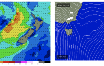
The broad SE’ly pattern which sets up in the Coral Sea gets disrupted next week by cold fronts whihc generate surf for NETas but longer term looks to set up again as we move to the end of the month.
/reports/forecaster-notes/eastern-tasmania/2025/06/16/not-much-week-small-ne-windswells-building-over
freeride76
Monday, 16 June 2025
From mid next week we should see action return to the south as fronts push into the Tasman.