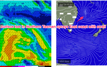
Spectacular charts more characteristic of late Summer/Autumn with a Cat 5 TC in the South Pacific bearing down on Vanuatu, and a powerful frontal intrusion poised to enter the Tasman Sea backed by a monster high in the Bight. A strong S-SE surge associated with this system spawns a surface low off the North Coast when it encounters a trough line in that zone.
Primary tabs
/reports/forecaster-notes/south-east-queensland-northern-new-south-wales/2023/10/25/powerful-swells
freeride76
Wednesday, 25 October 2023
/reports/forecaster-notes/south-east-queensland-northern-new-south-wales/2023/10/23/october-surprise
freeride76
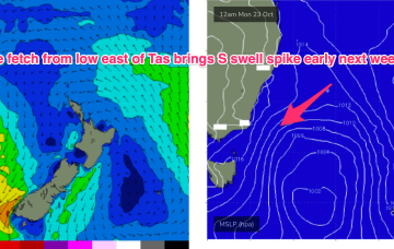
Monday, 23 October 2023
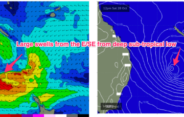
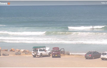
Late in the week, a combination of inland upper trough and a long angled trough extending from TC Lola remnants is expected to form a powerful surface low off the sub-tropical NSW Coast (likely between Lord Howe and Norfolk Is). As modelled, gales will produce a large E’ly quadrant swell event, with maximum size in Northern NSW, grading smaller into temperate NSW. A secondary October surprise that looks to be a major swell producer.
/reports/forecaster-notes/south-east-queensland-northern-new-south-wales/2023/10/20/easing-leftovers
freeride76
Friday, 20 October 2023
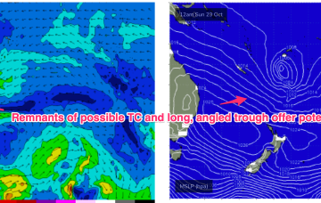
The potential TC is unlikely to be a swell source but there is one modelled track where it briefly pushes into the swell window between Vanuatu and New Caledonia, offering some potential for NE-E/NE swell Thurs/Fri. Very low confidence at the moment and likely to be swamped by dominant S-S/SE swell in the event it does occur. We’ll revisit on Mon.
/reports/forecaster-notes/south-east-queensland-northern-new-south-wales/2023/10/18/plenty-fun-waves
freeride76
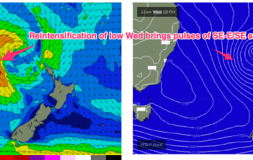
Wednesday, 18 October 2023
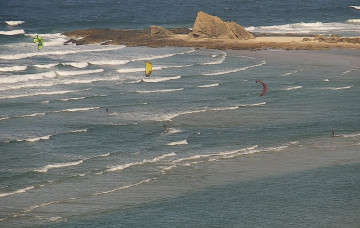
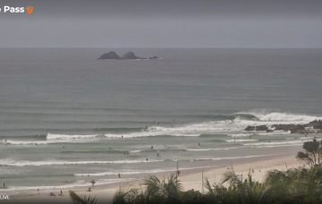
The synoptic set-up looks quite unseasonal at the moment with a 1031 hPa high drifting over NSW and a 1007 hPa low slow moving in the Tasman west of the North Island. Current ASCAT (satellite windspeed) passes show broad fetch of mostly strong S-S/SE winds with some embedded low end gales reasonably well aimed for East coast swell production.
/reports/forecaster-notes/south-east-queensland-northern-new-south-wales/2023/10/16/plenty-s-se-swell
freeride76
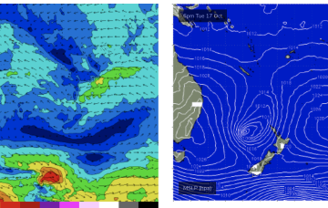
Monday, 16 October 2023
A strong front and embedded trough of low pressure are currently located just off the Gippsland Coast, expected too move NE into the Tasman and driving a strong/ near gale force S’ly flow up the NSW Coast today, reaching the QLD in the wee hours of Tuesday. There’ll be an initial burst of S swell associated with the proximate fetch, with some better quality SE-E/SE swell from a secondary intensification of the low as it becomes slow moving near New Zealand.
/reports/forecaster-notes/south-east-queensland-northern-new-south-wales/2023/10/13/workable-s-swells
freeride76
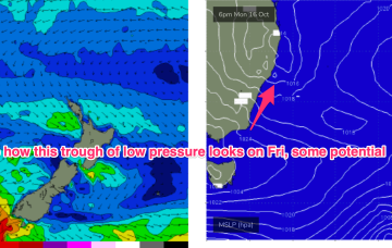
Friday, 13 October 2023
We’ve got more clarity on the situation next week now as a lingering trough line from the NSW South Coast down to Gippsland is expected to deepen in response to a front and form a surface low in the Tasman Sea, likely later Mon.
/reports/forecaster-notes/south-east-queensland-northern-new-south-wales/2023/10/11/october-nlies-the
freeride76
Wednesday, 11 October 2023
Moderate strength high pressure (1025 hPa) is drifting NE into the Tasman with a strong polar storm well SW of NZ exiting the swell window. That should see a settled short term before another complex trough and frontal system pushes north along the coast tomorrow with a stiff SW-S change. N'ly winds into the weekend under a very mobile, troughy pattern with some potential next week for a surface low to form in one of the trough lines.
/reports/forecaster-notes/south-east-queensland-northern-new-south-wales/2023/10/09/patchwork-quilt
thermalben
Monday, 9 October 2023
I’m not super confident on the weekend outlook.
/reports/forecaster-notes/south-east-queensland-northern-new-south-wales/2023/10/06/punchy-windy
thermalben
Friday, 6 October 2023
We've got more southerly swell on the way.
/reports/forecaster-notes/south-east-queensland-northern-new-south-wales/2023/10/04/solid-though
thermalben
Wednesday, 4 October 2023
We've had a slight tweak to the surf outlook for Thursday, mainly for SE Qld.