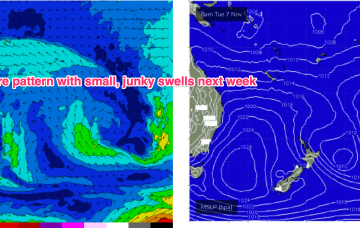
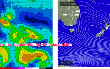
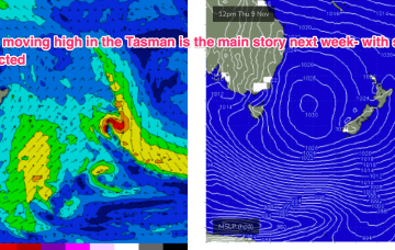
It’s a weak synoptic pattern with no major swell sources- a passing front weakens as it traverses the Tasman, leaving an off-axis fetch parallel with New Zealand. There should be enough minor swell sources of no real quality to stay wet through the short term.
Primary tabs
/reports/forecaster-notes/south-east-queensland-northern-new-south-wales/2023/11/22/spring-grovel
freeride76
Wednesday, 22 November 2023
/reports/forecaster-notes/south-east-queensland-northern-new-south-wales/2023/11/20/headed-spell
freeride76
Monday, 20 November 2023
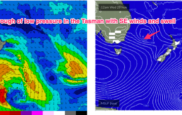
The troughy pattern remains installed into the medium term so we’re still keeping an eye out for short range features which could supply local swell sources, although these look small and weak.
/reports/forecaster-notes/south-east-queensland-northern-new-south-wales/2023/11/17/mix-swells
freeride76
Friday, 17 November 2023
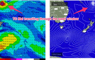
In the mix will be some inconsistent E swell from TC Mal’s run through the swell window. It accelerated as it hit the swell window so a slight winding back in size is justified but we’ll still see some defined sets in the 3 occ. 4ft range through Sat morning, easing during the day.
/reports/forecaster-notes/south-east-queensland-northern-new-south-wales/2023/11/15/mix-long-period-s
freeride76
Wednesday, 15 November 2023
TC Mal enters the swell window later today and we may see some small E/NE swell Sat. The TC moves at angles to the swell window which is not good for swell production but there are winds to 60kts as it enters the swell window o/night so we can expect some bigger 4ft sets with rogue 5ft sets a real possibility.
/reports/forecaster-notes/south-east-queensland-northern-new-south-wales/2023/11/13/complex-week
freeride76
Monday, 13 November 2023
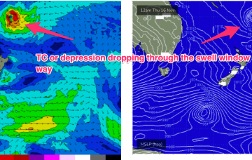
In addition the tropical depression or TC (Mal) which is expected to track SE through the swell window Wed/Thurs is expected to send some small E/NE swell our way. It’s a tricky, compact free-standing system but we can reasonably expect some 3 occ. 4ft sets Sat into Sun with revision to come this week.
/reports/forecaster-notes/south-east-queensland-northern-new-south-wales/2023/11/10/small-ely-swells
freeride76
Friday, 10 November 2023
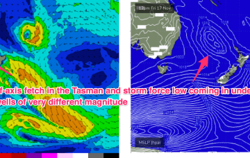
Much stronger frontal activity in the Far Southern Tasman tied to a deep, slow moving low will provide some long period S’ly groundswell pulses next week, favouring NENSW, although winds are looking very tricky around a troughy pattern.
/reports/forecaster-notes/south-east-queensland-northern-new-south-wales/2023/11/08/small-tradewind
freeride76
Wednesday, 8 November 2023
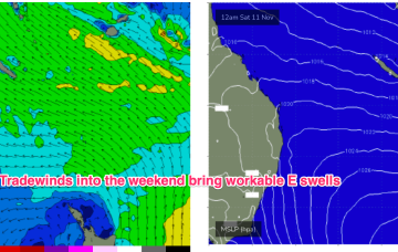
A weak ridge up the sub-tropics has a lighter E’ly flow with stronger N-NE winds developing south of the border. We’ll see this pattern with increasing NE windswell on the MNC and some workable trade swell in the sub-tropics.
/reports/forecaster-notes/south-east-queensland-northern-new-south-wales/2023/11/06/onshore-winds
freeride76
Monday, 6 November 2023
Surf-wise the tradewind fetch will be chugging away and like all tradewind fetches once we get a fully developed sea state we should see an improvement in size and quality.
/reports/forecaster-notes/south-east-queensland-northern-new-south-wales/2023/11/03/blocking-high-in
freeride76
Friday, 3 November 2023
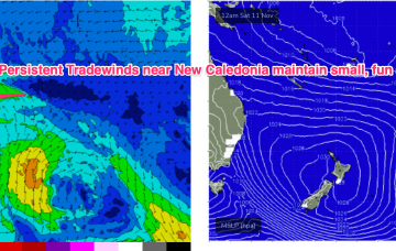
The trade flow is enhanced by another tropical development linked to a Westerly wind burst (WWB) extending from PNG longitudes into Fijian areas. This WWB is creating a long, angled trough through the South Pacific Convergence Zone and squeezing onto the large high as it moves slowly in New Zealand longitudes.
/reports/forecaster-notes/south-east-queensland-northern-new-south-wales/2023/11/01/easing-swells-the
freeride76
Wednesday, 1 November 2023
The deep Tasman low near the North Island has now dissipated and left the building with a small low in the Central/Southern Tasman supplying small S swells and an even smaller trough of low pressure off the Far North Coast directing SE winds onto the coast. This pattern remains slow moving as large high slowly approaches from South of the Bight and multiple inland troughs supply unstable weather.