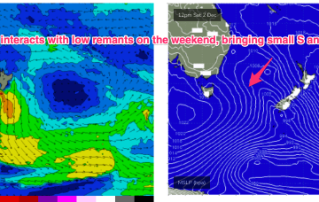
Wednesday is where we’ll start to see a gradual increase in new trade swell from a broad easterly fetch developing from this weekend onwards.
Primary tabs
/reports/forecaster-notes/south-east-queensland-northern-new-south-wales/2023/12/15/average-short
thermalben
Friday, 15 December 2023
/reports/forecaster-notes/south-east-queensland-northern-new-south-wales/2023/12/13/not-particularly
thermalben
Wednesday, 13 December 2023
The rest of the week looks very ordinary for SE Qld, mainly due to a freshening northerly flow.
/reports/forecaster-notes/south-east-queensland-northern-new-south-wales/2023/12/11/imminent-return
thermalben
Monday, 11 December 2023
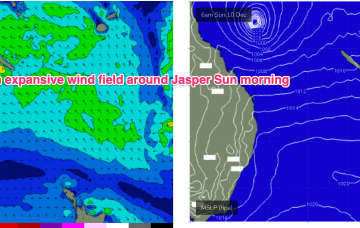
We're now at the peak of the swell cycle from STC Jasper so it's a slow dowards trend for the rest of the week.
/reports/forecaster-notes/south-east-queensland-northern-new-south-wales/2023/12/08/slow-moving-stc
freeride76
Friday, 8 December 2023
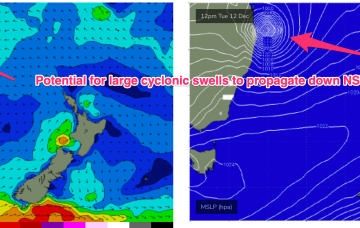
It’s slow (2-3kts) S/SW track between 158-156E is in the acute N/NE swell window- even though that part of the window tends to be flukey due to interference from reefs and it’s reliance on a perfect track to clear Fraser and the Breaksea Spit. That aids confidence in some steeply angled N/NE-NE groundswell from STC Jasper over the weekend.
/reports/forecaster-notes/south-east-queensland-northern-new-south-wales/2023/12/06/still-plenty-size
freeride76
Wednesday, 6 December 2023
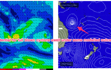
TC Jasper has formed in water surrounding the Solomon Islands and is intensifying under favourable conditions. Most models now are suggesting a SW-W curvature as it enters the Coral Sea, with a smaller surf potential compared to Mondays notes as it crosses the coast instead of tracking through the Coral Sea.

/reports/forecaster-notes/south-east-queensland-northern-new-south-wales/2023/12/04/cyclone-in-the
freeride76
Monday, 4 December 2023
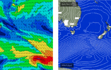
Weak high pressure in the Tasman and a trough is creating a “doldrums” type pattern of slack pressure gradients and small swells this week, with a few wind changes to negotiate. No major swells expected this week. The headline feature is a potential major tropical cyclone drifting into the Coral Sea with a poleward (southwards) track late this week, over the weekend and into next week.
/reports/forecaster-notes/south-east-queensland-northern-new-south-wales/2023/12/01/small-surf
freeride76
Friday, 1 December 2023
Further ahead and some weather model runs are starting to look pretty damn juicy with respect to a developing TC in the South Pacific moving into the Coral Sea later next week. Still very early days but a full blown cyclone swell is now a definite possibility, possibly as early as next weekend and into the week 9/12
/reports/forecaster-notes/south-east-queensland-northern-new-south-wales/2023/11/29/back-small-and
freeride76
Wednesday, 29 November 2023
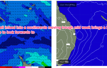
In the South Pacific the previously active area near the Solomons that has already spawned two tropical cyclones looks to flare up again next week with convective activity enhanced by a cross-equatorial flow. We may see a new tropical depression or even cyclone form later next week, with uncertain surf potential at this very early stage.
/reports/forecaster-notes/south-east-queensland-northern-new-south-wales/2023/11/27/more-weak-grovel
freeride76
Monday, 27 November 2023
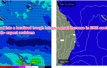
A small trough of low pressure off the sub-tropical coast (SEQLD likely) will see a brief flush of E/NE swell. One bright spot in a very dull forecast.
/reports/forecaster-notes/south-east-queensland-northern-new-south-wales/2023/11/24/keep-the
freeride76
Friday, 24 November 2023
High pressure is straddling Tasmania with the remnants of a front lingering near New Zealand with an off-axis fetch. A coastal trough and an inland trough maintain unstable conditions with a developing N-NE flow over the weekend.