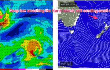
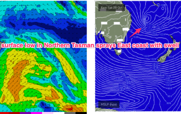
The Tasman low of sub-tropical origins which has sprayed the East Coast with swell is now just north of the North Island, with some swell generating winds still active to the west of the North Island, although quite limited in length. It’s deepened and is hammering the North Island sending another pulse of E/SE swell our way.
Primary tabs
/reports/forecaster-notes/south-east-queensland-northern-new-south-wales/2023/10/30/surf-keeps-coming
freeride76
Monday, 30 October 2023
/reports/forecaster-notes/south-east-queensland-northern-new-south-wales/2023/10/27/still-solid-the-e
freeride76
Friday, 27 October 2023
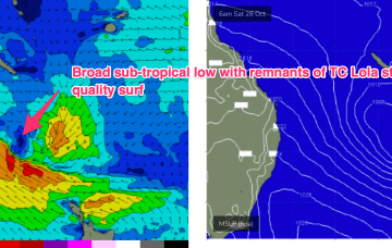
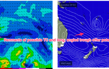
The evolution of the surface low in the sub-tropics is complicated and running a little behind schedule, but as we suggested on Wed we’ll see the remnants of severe TC Lola drift into and become absorbed into the large low centre over the weekend as it approaches the North Island.
/reports/forecaster-notes/south-east-queensland-northern-new-south-wales/2023/10/25/powerful-swells
freeride76
Wednesday, 25 October 2023
Spectacular charts more characteristic of late Summer/Autumn with a Cat 5 TC in the South Pacific bearing down on Vanuatu, and a powerful frontal intrusion poised to enter the Tasman Sea backed by a monster high in the Bight. A strong S-SE surge associated with this system spawns a surface low off the North Coast when it encounters a trough line in that zone.
/reports/forecaster-notes/south-east-queensland-northern-new-south-wales/2023/10/23/october-surprise
freeride76
Monday, 23 October 2023
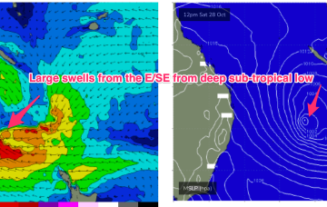
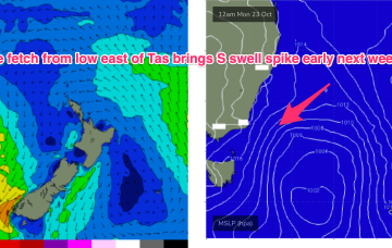
Late in the week, a combination of inland upper trough and a long angled trough extending from TC Lola remnants is expected to form a powerful surface low off the sub-tropical NSW Coast (likely between Lord Howe and Norfolk Is). As modelled, gales will produce a large E’ly quadrant swell event, with maximum size in Northern NSW, grading smaller into temperate NSW. A secondary October surprise that looks to be a major swell producer.
/reports/forecaster-notes/south-east-queensland-northern-new-south-wales/2023/10/20/easing-leftovers
freeride76
Friday, 20 October 2023
The potential TC is unlikely to be a swell source but there is one modelled track where it briefly pushes into the swell window between Vanuatu and New Caledonia, offering some potential for NE-E/NE swell Thurs/Fri. Very low confidence at the moment and likely to be swamped by dominant S-S/SE swell in the event it does occur. We’ll revisit on Mon.
/reports/forecaster-notes/south-east-queensland-northern-new-south-wales/2023/10/18/plenty-fun-waves
freeride76
Wednesday, 18 October 2023
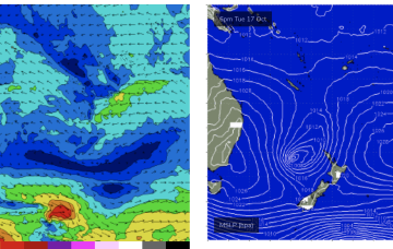
The synoptic set-up looks quite unseasonal at the moment with a 1031 hPa high drifting over NSW and a 1007 hPa low slow moving in the Tasman west of the North Island. Current ASCAT (satellite windspeed) passes show broad fetch of mostly strong S-S/SE winds with some embedded low end gales reasonably well aimed for East coast swell production.
/reports/forecaster-notes/south-east-queensland-northern-new-south-wales/2023/10/16/plenty-s-se-swell
freeride76
Monday, 16 October 2023
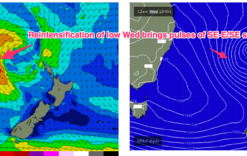
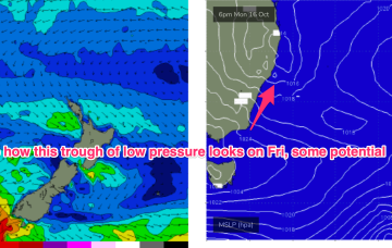
A strong front and embedded trough of low pressure are currently located just off the Gippsland Coast, expected too move NE into the Tasman and driving a strong/ near gale force S’ly flow up the NSW Coast today, reaching the QLD in the wee hours of Tuesday. There’ll be an initial burst of S swell associated with the proximate fetch, with some better quality SE-E/SE swell from a secondary intensification of the low as it becomes slow moving near New Zealand.
/reports/forecaster-notes/south-east-queensland-northern-new-south-wales/2023/10/13/workable-s-swells
freeride76
Friday, 13 October 2023
We’ve got more clarity on the situation next week now as a lingering trough line from the NSW South Coast down to Gippsland is expected to deepen in response to a front and form a surface low in the Tasman Sea, likely later Mon.
/reports/forecaster-notes/south-east-queensland-northern-new-south-wales/2023/10/11/october-nlies-the
freeride76
Wednesday, 11 October 2023
Moderate strength high pressure (1025 hPa) is drifting NE into the Tasman with a strong polar storm well SW of NZ exiting the swell window. That should see a settled short term before another complex trough and frontal system pushes north along the coast tomorrow with a stiff SW-S change. N'ly winds into the weekend under a very mobile, troughy pattern with some potential next week for a surface low to form in one of the trough lines.
/reports/forecaster-notes/south-east-queensland-northern-new-south-wales/2023/10/09/patchwork-quilt
thermalben
Monday, 9 October 2023
I’m not super confident on the weekend outlook.