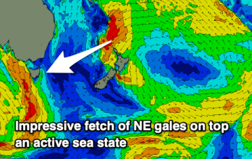
The high will move E with a N’ly flow rapidly developing as pressure gradients get tightened by an approaching front, complex low and trough line, generating solid NE windswell.
Primary tabs
/reports/forecaster-notes/eastern-tasmania/2022/09/07/solid-ne-windswell-incoming-tomorrow
freeride76
Wednesday, 7 September 2022
/reports/forecaster-notes/eastern-tasmania/2022/09/05/easing-s-swells-chunky-ne-windswell-thursfri
freeride76
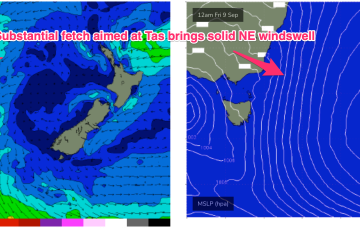
Monday, 5 September 2022
This seabreeze heralds a strong N’ly flow developing off the South Coast and down to Bass Strait Thursday morning, which is expected to produce a chunky NE windswell for Thurs, under fresh NE winds.

/reports/forecaster-notes/eastern-tasmania/2022/09/02/long-period-sly-swells-ahead-troublesome-winds
freeride76
Friday, 2 September 2022
Bit of a downgrade for next weeks surf prospects. Firstly, because the S’ly flow remains more stubbornly entrenched through Mon and Tues- although we should start seeing morning land breezes develop at least by Tues morning. Secondly, the deep polar low outbreak now really winds up a little further E (favouring California!) so we’re more exposed to sideband energy rather than the main course.
/reports/forecaster-notes/eastern-tasmania/2022/08/31/solid-s-swell-pulses-over-the-weekend-and-next
freeride76
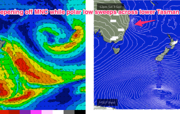
Wednesday, 31 August 2022
The current pattern- with weak high pressure drifting across Central NSW and a soft ridge along the coast- will be replaced in emphatic fashion by a much stronger front and trough on Friday, forming a surface low off the Mid North Coast, anchored by a monster high moving into the Bight at the same time. Well to the south of that set-up will be a deep polar low and associated fronts with severe gales to storm force winds generating long period S’ly swells to make landfall over the weekend and into early next week.
/reports/forecaster-notes/eastern-tasmania/2022/08/29/fun-ne-windswell-tomorrow-strong-s-swell
freeride76
Monday, 29 August 2022
A much stronger change on Sat looks to form a low in the Central/Northern Tasman with a more substantial swell increase also being generated by a deep polar low transiting the Tasman.

/reports/forecaster-notes/eastern-tasmania/2022/08/26/slow-period-south-swell-next-weekend
Craig
Friday, 26 August 2022
A weak N/NE windswell will stop the coast going flat but next weekend looks more promising for surf.
/reports/forecaster-notes/eastern-tasmania/2022/08/24/few-small-surf-options-over-the-coming-week
freeride76
Wednesday, 24 August 2022
Into the medium term and a series of deep lows and fronts amassed in the Southern Ocean look to send some small, long period refracted S swell to Tas towards the end of next week. No great size is expected due to the swell direction, so expect some 2ft days to bring in the first days of Spring.
/reports/forecaster-notes/eastern-tasmania/2022/08/22/few-small-swell-sources-week-mostly-offshore
freeride76
Monday, 22 August 2022
We’ll monitor those precursor building blocks for another round of E swell in the medium/long term but for now, it’s the Tasman Sea that has most of the action, with small S swell pulses expected this week.

/reports/forecaster-notes/eastern-tasmania/2022/08/19/inconsistent-great-quality-swell-inbound
Craig
Friday, 19 August 2022
The incoming E/NE groundswell has come in nicely across NSW though a touch delayed. The weekend should be really fun.
/reports/forecaster-notes/eastern-tasmania/2022/08/17/great-though-lully-ene-groundswell
Craig
Wednesday, 17 August 2022
Building surf this period out of the E/NE with a prolonged but inconsistent event.