That size holds though Tues-Wed- or even a notch above in the 4-6ft range- offering up fantastic potential under light winds Tues, with winds tending more W’ly Wed as a weak front crosses the state.
Primary tabs
/reports/forecaster-notes/eastern-tasmania/2022/07/22/great-outlook-next-week-coral-sea-low-drifts
freeride76
Friday, 22 July 2022
/reports/forecaster-notes/eastern-tasmania/2022/07/20/coral-sea-low-drifting-south-brings-solid-ene
freeride76
Wednesday, 20 July 2022
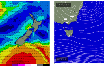
The remains of a low near the South Island are continuing to send south quadrant swells towards Tasmania and, most notably, a trough of low pressure in the Coral Sea is deepening and expected to activate into a fully fledged Coral Sea surface low as an upper trough moves over it from inland QLD tomorrow. This low will provide large E’ly quadrant swells for a huge swathe of the Eastern Seaboard, from the Central QLD Coast to Tasmania over the coming week.
/reports/forecaster-notes/eastern-tasmania/2022/07/18/winter-s-swells-then-surf-the-ne-and-ene-over
freeride76
Monday, 18 July 2022
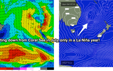
Surf comes from a wide variety of sources this week as a typical strong winter cold front gets shunted aside by a very La Niña looking synoptic pattern, more reminiscent of Feb/Mar than July. This will see a very strong southwards located high pressure system set up a strong ridge along most of the Eastern seaboard, acting as an anvil for a tropical low to push against later in the week
/reports/forecaster-notes/eastern-tasmania/2022/07/15/run-southerly-swell-next-week
Craig
Friday, 15 July 2022
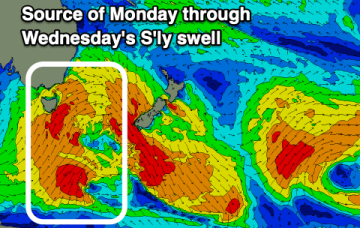
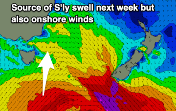
Nothing to work around on the weekend, with windy south swells into early-mid next week.
/reports/forecaster-notes/eastern-tasmania/2022/07/13/fading-east-swell-potential-next-week
Craig
Wednesday, 13 July 2022
Small, easing easterly energy with a mix of swells on the cards for next week.
/reports/forecaster-notes/eastern-tasmania/2022/07/11/small-mixed-bag-week-enough-energy-surf-most
freeride76
Monday, 11 July 2022
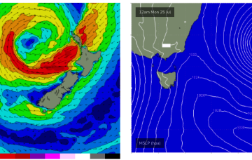
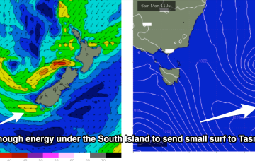
The remnants of the Tasman Low (ex ECL) are now drifting near the South Island, on top of a large high which is slowly moving out of the Tasman Sea. A high is approaching from the South Australian interior, with a trough expected to form off the coast later Tues and develop a broad, relatively weak low in the Central/Northern Tasman.
/reports/forecaster-notes/eastern-tasmania/2022/07/08/solid-swell-incoming-problem-winds-improving
freeride76
Friday, 8 July 2022
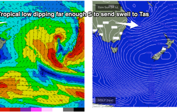
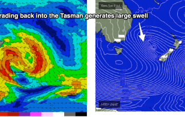
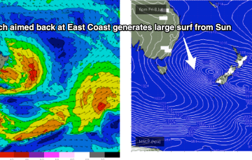
The new trough/low is generating gales out of Bass Strait and up towards the South Coast. The main low is drifting towards the South Island and intensifying today, with gales to severe gales expected to retrograde NW back into the Tasman Sea (see below), generating a large swell for Sun/Mon.
/reports/forecaster-notes/eastern-tasmania/2022/07/06/strong-swell-pulses-ahead-low-intensifies-near
freeride76
Wednesday, 6 July 2022
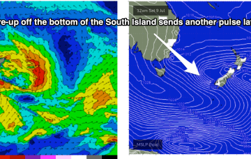
By Friday the low will have moved towards the West Coast of the South Island, where it intensifies again, generating strong surf for East Coast Tasmania.
/reports/forecaster-notes/eastern-tasmania/2022/07/04/small-week-ahead-some-solid-swell-fri-and-the
freeride76
Monday, 4 July 2022
Much better quality swell arrives Sun, generated by gales near the South Island aimed back towards East Coast targets.
/reports/forecaster-notes/eastern-tasmania/2022/07/01/small-mixed-bag-weekend-and-next-week-surf-the
freeride76
Friday, 1 July 2022
Small amounts of E/NE swell will build later Mon, into the 2ft range as a Easterly trough low forming off the Sydney coast remains slow moving over the weekend.