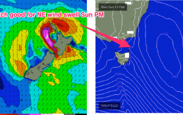
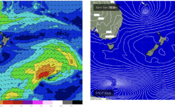
N’ly winds do perk up off the South Coast and into Bass Strait later Sun, which should see NE windswell lift into the 3ft range later Sun.
Primary tabs
/reports/forecaster-notes/eastern-tasmania/2022/02/11/small-ne-wind-swell-sun-pm-then-not-much-the
freeride76
Friday, 11 February 2022
/reports/forecaster-notes/eastern-tasmania/2022/02/09/flukey-swells-the-end-the-week-and-weekend
freeride76
Wednesday, 9 February 2022
The weekend isn’t looking great with a small mixed bag of 1-2ft surf both days, lifting a notch Sun a’noon as NE wind swell builds in under freshening N’ly winds.
/reports/forecaster-notes/eastern-tasmania/2022/02/07/good-mix-easterly-swells-inbound
Craig
Monday, 7 February 2022
There's a good mix of easterly swells on the way for the coast, cleanest as it peaks and fun while it eases.
/reports/forecaster-notes/eastern-tasmania/2022/02/04/few-swell-sources-the-radar-mixed-bag-winds
freeride76
Friday, 4 February 2022
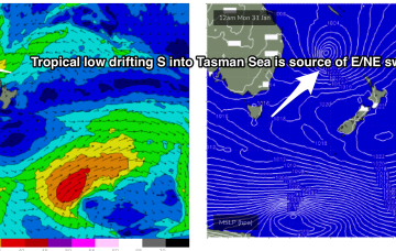
While this swell is aimed at NSW, the fetch continues to dip south as it weakens, eventually reaching the Eastern Tas swell window later Mon.
/reports/forecaster-notes/eastern-tasmania/2022/02/02/easing-easterly-energy-building-south
Craig
Wednesday, 2 February 2022
A mix of swells over the coming days but mainly easing from the east-northeast and pulsing from the south.
/reports/forecaster-notes/eastern-tasmania/2022/01/31/very-active-period-ahead-though-windy
Craig
Monday, 31 January 2022
There's plenty of swell on the cards but you'll have to work the local winds.
/reports/forecaster-notes/eastern-tasmania/2022/01/28/lots-action-ahead-dynamic-pattern-plays-out
freeride76
Friday, 28 January 2022
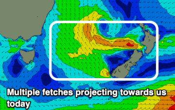
This is a particularly broad fetch and while there its still some model variance on windspeed in the fetch its on track to supply some good quality E/NE swell for the East Coast of Tasmania.
/reports/forecaster-notes/eastern-tasmania/2022/01/26/pulses-ne-windswell-ahead-stronger-ene
freeride76
Wednesday, 26 January 2022
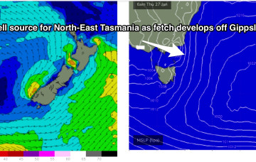
First from the western flank of the high as the tightened pressure gradient sees N’ly winds freshening off the Gippsland coast and aimed well at NE Tas.
/reports/forecaster-notes/eastern-tasmania/2022/01/24/juicy-pulses-ne-windswell-and-ene-groundswell
freeride76
Monday, 24 January 2022
New high pressure slips into the Tasman Thursday and immediately has the pressure gradient on the western flank tightened by an interior trough system. That sees a fast developing N to NE fetch off the Far South Coast and Gippsland build NE windswell off the NE Coast of Tasmania during Thurs.
/reports/forecaster-notes/eastern-tasmania/2022/01/21/tiny-surf-ahead-ne-windswell-the-radar-next
freeride76
Friday, 21 January 2022
The blocking pattern remains in place for most of next week. First, the initial high maintains position just East of Tasmania with weak pressure gradients and only light N to NE winds in the swell window- not enough to generate any more than a foot or so of weak windswell.