Mixed south swells followed by east
Eastern Tasmanian Surf Forecast by Craig Brokensha (issued Wednesday June 29th)
Best Days: South magnets Friday and Monday, open beaches Tuesday
Features of the Forecast (tl;dr)
- Mix of S'ly swells Fri with W/SW tending variable winds
- Easing S swell Sat with background pulses Sun with morning W/SW winds and PM sea breezes
- Strong S'ly groundswell for Mon with W/NW tending NE winds
- Fun E/NE swell for later Mon, peaking Tue
Recap
Tiny to flat conditions with no surf.
This week and weekend (Jun 30 – Jul 3)
We've got a bit more activity due from the south over the coming days as a series of strong polar storms glance our swell window.
The best chance for finding a surfable wave looks to be Friday when we see a mix of S'ly groundswell and mid-period S'ly swell peaking.
The groundswell has been generated by a strong polar low, producing a fetch of severe-gale to storm-force W'ly winds, while a weaker trailing front will project strong SW winds up towards the southern Tasman Sea this evening and tomorrow.
Don't expect any size tomorrow afternoon, but Friday should hopefully see 3ft sets on the south magnets with W/SW tending variable winds. Not the best combination but there should be a few small runners about.
The mix of swells will ease Saturday from a small 2ft, with background energy likely to maintain the odd stray 1-2ft sets on the magnets Sunday.
Winds looks light and from the W/SW Saturday morning ahead of late afternoon sea breezes, and then W/NW tending NE winds Sunday.
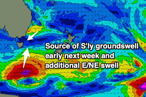
 Into Monday a fresh pulse of long-period S'ly groundswell is due, generated by a very strong but fast tracking polar through our southern swell window on the weekend. Winds will reach severe-gale to storm-force and this should produce a strong but fleeting pulse of S'ly groundswell to 3-4ft on the south magnets if the low eventuates as currently forecast.
At the same time some building E/NE swell is due from deepening low off the southern NSW coast, with an infeed of strong to gale-force E/SE winds sitting just within our swell window.
The models are still struggling re the positioning and longevity of this low but at this stage we may see a small 3ft+ pulse of swell for later Monday but more so Tuesday. Check back Friday for a clearer idea on the expected swell from this source.

