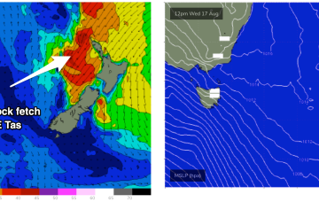
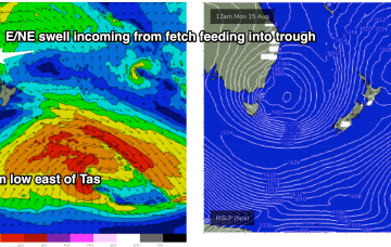
A deep low just to the East of Tasmania is now slowly weakening and moving away, maintaining a westerly flow across the region. A trough line linked to the low extends from the Tasman Sea up into the Coral Sea past New Caledonia and over the next few days this trough deepens as it slowly moves East, activating an incredibly wide fetch of E to NE winds infeeding into it.
Primary tabs
/reports/forecaster-notes/eastern-tasmania/2022/08/15/good-quality-ene-swell-incoming-later-week
freeride76
Monday, 15 August 2022
/reports/forecaster-notes/eastern-tasmania/2022/08/12/plenty-swell-the-eastern-quadrant-near-and-long
freeride76
Friday, 12 August 2022
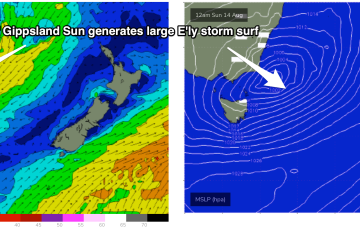
The low will approach Tasmania over the weekend with a strong E’ly infeed expected to generate large surf. Models now show much less size as the fetch is not directly aimed at Tasmania and not as powerful as Wed’s notes indicated. We’re still looking at solid surf through from Sun into next week!
/reports/forecaster-notes/eastern-tasmania/2022/08/10/xl-surf-likely-build-sun-low-drifts-e-tasmania
freeride76
Wednesday, 10 August 2022
There’s still some model divergence on the position of the low on Sun, and a fetch of strong winds on the southern flank of the low. Either way we’ll see large storm surf from the SE to ESE develop, in conjunction with building NE swell.
/reports/forecaster-notes/eastern-tasmania/2022/08/08/nice-pulses-swell-week-large-storm-surf
freeride76
Monday, 8 August 2022
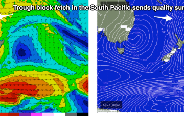
Several juicy fetches will send swell across the Tasman this week with a low moving E of Bass Strait on the weekend expected to see large storm surf develop.
/reports/forecaster-notes/eastern-tasmania/2022/08/05/plenty-juicy-swell-pulses-next-week-low-fires
freeride76
Friday, 5 August 2022
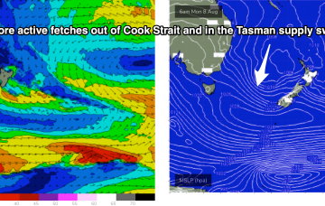
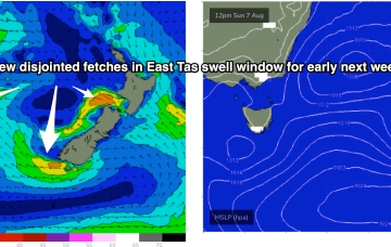
Into next week and the outlook is much juicier than Wed’s notes suggested as the low reforms near New Zealand with multiple swell generating fetches in the Eastern Tas swell window.
/reports/forecaster-notes/eastern-tasmania/2022/08/03/small-fun-sources-swell-ahead-spring-pattern
freeride76
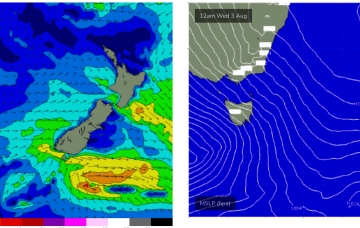
Wednesday, 3 August 2022
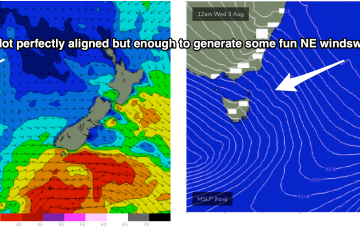
N'ly winds are broadening off the coast of NSW, as the pressure gradient is tightened between a mobile high and the approaching low.
/reports/forecaster-notes/eastern-tasmania/2022/08/01/few-fun-days-ne-windswell-and-nw-winds-later
freeride76
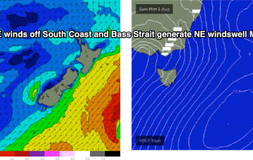
Monday, 1 August 2022
The high pressure belt is moving at a more typical northerly latitude over interior Australia and with weaker, more mobile high pressure moving over the interior and into the Tasman, we are looking at a period of N’ly biased winds with W’ly oriented fronts being quickly shunted across the Tasman.
/reports/forecaster-notes/eastern-tasmania/2022/07/29/small-pulses-ne-windswell-next-week-in-between
freeride76
Friday, 29 July 2022
High pressure rapidly moves off the NSW Coast early next week, driving a N’ly flow off the South Coast into Bass Strait. Unfortunately, this fetch is now disjointed and rapidly shifts to the NW through Mon.
/reports/forecaster-notes/eastern-tasmania/2022/07/27/last-the-groundswell-thurs-some-ne-windswell
freeride76
Wednesday, 27 July 2022
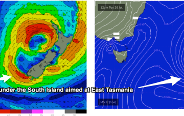
We are now close to the end game as the low which started off the CQ Coast in the Coral Sea expends it’s last energy off the bottom of the South Island New Zealand, with a fetch still well aimed for East Coast Tasmania.
/reports/forecaster-notes/eastern-tasmania/2022/07/25/great-outlook-week-swell-the-e-and-offshore
freeride76
Monday, 25 July 2022
Current ASCAT (satellite windspeed) pass shows storm force winds embedded in a larger fetch of SE-ESE gales to severe gales aimed back at the Eastern Seaboard including Tasmania.