Fading east swell with potential next week
Eastern Tasmanian Surf Forecast by Craig Brokensha (issued Wednesday July 13th)
Best Days: Tomorrow morning for the keen, mid-late next week
Features of the Forecast (tl;dr)
- Small, easing E/SE swell tomorrow with W/SW tending variable winds, W/NW tending weak SE on Fri
- Tiny E/SE swell on the weekend
- New S swell building Mon, easing Tue with freshening SE winds
- Building E/NE swell Tue, peaking Wed with SE tending S/SW winds
Recap
Small, fun levels of fun E/SE swell yesterday and this morning, best in protected spots today with a S'ly change.
This week and weekend (Jul 14 - 17)
 The current E/SE swell will fade into the end of the week with clean conditions but fading 1-2ft sets tomorrow, tiny Friday.
A W/SW tending variable NE breeze is due tomorrow with W/NW winds on Friday ahead of a shallow afternoon SE change.
Looking at the weekend and there's nothing major on the cards but a distant signal of E/SE swell may maintain 1-1.5ft sets for beginners.
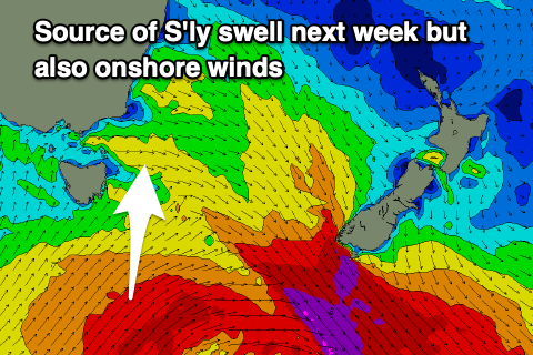
Following this, there's no new swell due until we see polar front firing up south of us on Sunday.
This should generate a fun pulse of S'ly energy Monday afternoon and Tuesday with sets in the 3-4ft on the magnets at this stage.
 Winds are suspect at the moment as a trough spawning off the cold outbreak deepens off out coast, bringing fresh S tending SE winds. This trough should kick up some stormy E'ly swell through Tuesday, hopefully cleaning up on Wednesday as the trough drifts south and swings winds S/SW.
This is a dynamic system and period from next week onwards so check back Friday for a clearer idea on how it's shaping up.

