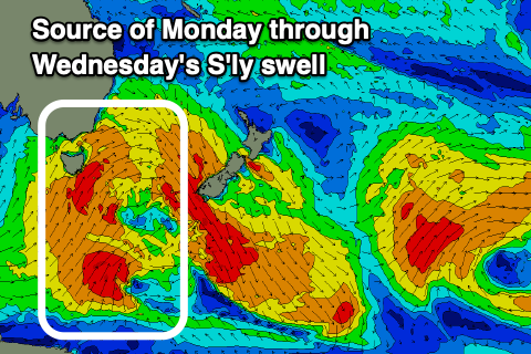
Run of southerly swell next week
Eastern Tasmanian Surf Forecast by Craig Brokensha (issued Friday July 15th)
Best Days: Protected spots for the keen later Monday, Tuesday and Wednesday morning, Thursday south magnets
Features of the Forecast (tl;dr)
- Tiny E/SE swell tomorrow, fading Sun with strengthening N/NW winds on Sat, NW on Sun
- Moderate sized + mix of mid-period S'ly swell and S'ly groundswell building Mon with fresh SW tending strong S winds
- Moderate sized + mix of mid-period S'ly swell and S'ly groundswell easing Tue with gusty S/SW tending S/SE winds
- Mod sized, easing swell Wed with SW-S/SW tending SE winds
- Smaller Thu with W tending E winds
Recap
Small, clean but easing surf yesterday, tiny today.
This weekend and next week (Jul 16 - 22)
There's no change to the weekend forecast with a tiny hint of background E/SE swell to 1-1.5ft tomorrow, fading on Sunday as winds strengthen from the NW ahead of an approaching frontal progression.
 Moving into next week and to the polar frontal progression/outbreak across the state. We've got an upgrade in the strength, with a great fetch of S/SW gales now forecast to be projected up into and then past us, producing a moderate sized + mix of mid-period S'ly swell and S'ly groundswell for Monday afternoon and Tuesday morning.
The only issue are the local winds still, but we should see sets building to 4-5ft on the south magnets later Monday (small in the AM) with SW tending strong S'ly winds. The swell should ease back slowly from 4-5ft on Tuesday morning but with gusty S/SW tending S/SE winds.
Unfortunately the lingering nature of the polar frontal progression will see unfavourable SW-S/SW winds on Wednesday morning with the S'ly swell, dropping back from 4ft.
Thursday looks cleaner but smaller and fading from 2ft.
Longer term we've got nothing major on the cards for next weekend, but we'll have a closer look at this Monday. Have a great weekend!

