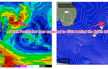
Sunday looks better, for size at least. The head of the fetch reaches almost to New Caledonia and this typically aids S swell penetration into SEQLD.
Primary tabs
/reports/forecaster-notes/south-east-queensland-northern-new-south-wales/2023/08/18/stiff-august
freeride76
Friday, 18 August 2023
/reports/forecaster-notes/south-east-queensland-northern-new-south-wales/2023/08/16/brief-tricky
thermalben
Wednesday, 16 August 2023
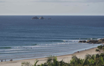
Easing swells are expected for the rest of the week, and northerlies will give it a kick in the pants on Thursday afternoon.
/reports/forecaster-notes/south-east-queensland-northern-new-south-wales/2023/08/14/flukey-winds
freeride76
Monday, 14 August 2023
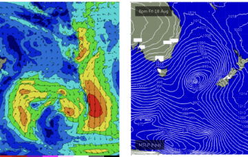
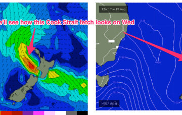
We’ve got a weak, troughy pattern unfolding now adjacent to the NSW Coast in the near Tasman Sea that will provide plenty of wind changes this week. A low pressure system near the South Island reached maximum strength last night and is now slowly easing, but still looking good on ASCAT (satellite windspeed) passes with S’ly strong winds to gales aimed up the Tasman pipe. That will be our main source of swell this week.

/reports/forecaster-notes/south-east-queensland-northern-new-south-wales/2023/08/11/small-wave
freeride76
Friday, 11 August 2023
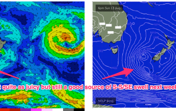
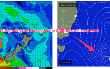
As mentioned on Wed the weekend’s front forms a low which looks to stall in the central/eastern Tasman Sun/Mon, and possibly linger near the South Island after that. The fetch now, isn’t quite so well aimed back at the East Coast but we’re still on track for a nice pulse of S-S/SE swell.
/reports/forecaster-notes/south-east-queensland-northern-new-south-wales/2023/08/09/easing-surf
freeride76
Wednesday, 9 August 2023
A stronger frontal system now looks likely to be a bit delayed but stall nicely in the Eastern Tasman early next week and supply some useful S/SE swell.
/reports/forecaster-notes/south-east-queensland-northern-new-south-wales/2023/08/07/tradewind-swells
freeride76
Monday, 7 August 2023
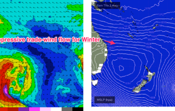
A persistent tradewind fetch is in the process of resetting with a less favourable wind alignment and easing swells. No major swell sources on the radar so lets look at a few bits and pieces on offer this week.
/reports/forecaster-notes/south-east-queensland-northern-new-south-wales/2023/08/04/plenty-fun-ely
freeride76
Friday, 4 August 2023
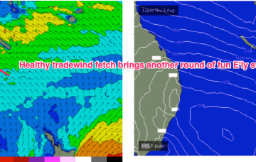
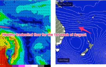
Current ASCAT (satellite windspeed) passes show a very healthy fetch of SE-E/SE tradewinds extending through the Central/Southern Coral Seas with plenty of fun E’ly tradewind swell expected over the weekend.
/reports/forecaster-notes/south-east-queensland-northern-new-south-wales/2023/08/02/plenty-fun
freeride76
Wednesday, 2 August 2023
In the wake of a strong front earlier this week we have still have moderate S swell trains propagating through the Tasman Sea which will be one swell source through the short term. The bifurcation between the sub-tropics and temperate regions increases through the end of the week with NE windswell in the temperate areas and E’ly tradewind swells building in the sub-tropics.
/reports/forecaster-notes/south-east-queensland-northern-new-south-wales/2023/07/31/mid-week-s-swell
freeride76
Monday, 31 July 2023
Once the dominant high enters the Tasman on Wed we’ll see a SE’ly to E'ly tradewind pattern start to establish through the Coral Sea, more typical of Summer, likely extending into the weekend with plenty of workable tradewind swell associated with it.
/reports/forecaster-notes/south-east-queensland-northern-new-south-wales/2023/07/28/small-weekend
freeride76
Friday, 28 July 2023
A trough and cold front are being rapidly shunted southwards by a blocking high which is moving NE into the sub-tropical Tasman and weakening. The current swell sources are slowly drying up leaving us with small background swells for the weekend.