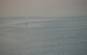
During the morning, a low will form in the western Tasman Sea, driving gusty southerly winds along the Mid North Coast into the afternoon ahead of an overnight arrival into SE Qld.
Primary tabs
/reports/forecaster-notes/south-east-queensland-northern-new-south-wales/2022/06/24/temporarily-back
thermalben
Friday, 24 June 2022
/reports/forecaster-notes/south-east-queensland-northern-new-south-wales/2022/06/22/couple-days
freeride76
Wednesday, 22 June 2022
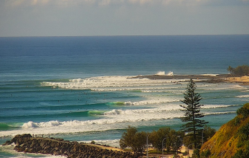
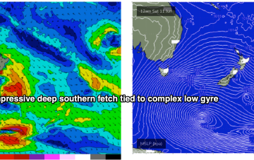
The tropical low over the North Island has rotated out of the swell window, dissipating quickly as it did so. We’ve still got some fun, albeit downgraded, E’ly quadrant swell inbound from that source before a period of quiet surf becomes established over the weekend.
/reports/forecaster-notes/south-east-queensland-northern-new-south-wales/2022/06/20/downgraded-notch
freeride76
Monday, 20 June 2022
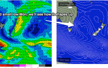
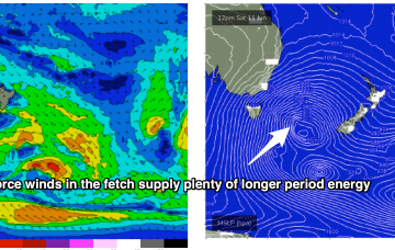
As well as a precursor SE fetch adjacent to the South Island it is now squeezing pressure gradients with a compact, but deep low, which is currently forming gale force fetches out of Cook Strait and just north of the North Island. Compared to Fridays model runs the fetch now is a little more mobile, weaker and rotates faster out of the swell producing phase, which will see a bit of a downgrade. Still some good waves on offer though.
/reports/forecaster-notes/south-east-queensland-northern-new-south-wales/2022/06/17/active-tasman
thermalben
Friday, 17 June 2022
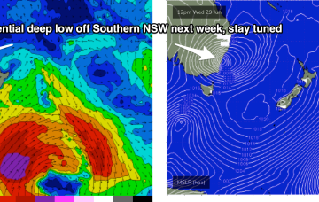
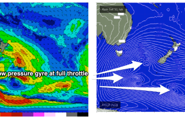
A broad region of troughiness stretching from the Tasman Sea through the Coral Sea over the weekend will coalesce into a major sub-tropical low off New Zealand’s North Island, on Monday.

/reports/forecaster-notes/south-east-queensland-northern-new-south-wales/2022/06/15/south-swell
freeride76
Wednesday, 15 June 2022
The Southern Ocean gyre is now well to the S and SE of the South Island, generating one last pulse of long period swell for our region. There’s a fresh set of cards to sort through next week with a couple of swell sources on offer. Read on for details.

/reports/forecaster-notes/south-east-queensland-northern-new-south-wales/2022/06/13/another-week-s
freeride76
Monday, 13 June 2022
More fronts maintain a synoptic offshore flow (or light winds) for the week and we’ve got plenty of S swell to last the week, albeit at reduced sizes compared to the weekend.

/reports/forecaster-notes/south-east-queensland-northern-new-south-wales/2022/06/10/s-swell-and
freeride76
Friday, 10 June 2022
Current ASCAT (satellite wind speed) passes show gales to severe gales extending down to 55S with a tighter core of storm force winds just emerging from behind Tasmania as it tracks NE into the Tasman Sea. The synoptic flow from the fronts and Southern Gyre remains W to W/SW and that will continue all weekend with plenty of wind chill to boot.
/reports/forecaster-notes/south-east-queensland-northern-new-south-wales/2022/06/08/extended-s-swell
freeride76
Wednesday, 8 June 2022
Strong high pressure support from a 1033hPa elongated high in the Bight is providing tight pressure gradients for the multiple fronts spinning off the gyre. That will lead to numerous over-lapping S’ly pulses over the coming week with a general step-ladder effect expected at least through to Mon. A general offshore flow will accompany these pulses as the fronts drive W’ly biased winds across the temperate to sub-tropical East Coast.
/reports/forecaster-notes/south-east-queensland-northern-new-south-wales/2022/06/06/extended-round-s
freeride76
Monday, 6 June 2022
A strong node of the long wave trough is steering fronts into the Tasman Sea while a negative phase of the SAM (Southern Annular Mode) is bringing the southern Ocean storm track into a more northerly latitude, closer to the Australian continent and Tasman Sea. Both those factors will drive a series of strong cold fronts this week, with a step-ladder effect likely as each subsequent front works on an already charged sea state.
/reports/forecaster-notes/south-east-queensland-northern-new-south-wales/2022/06/03/lot-more-southern
thermalben
Friday, 3 June 2022
Using today's results in Southern NSW as a proxy, we should see some solid south swell across Northern NSW on Saturday.