E’ly swell keeps chugging along this week. Despite some slow periods between pulses the ASCAT (satellite windspeed) passes shows a long, broad fetch of strong winds with gales embedded around a tropical depression. That leads to high confidence in continuing pulsey swell from that South Pacific source fetch.
Primary tabs
/reports/forecaster-notes/south-east-queensland-northern-new-south-wales/2022/10/12/slow-fade-out-e
freeride76
Wednesday, 12 October 2022
/reports/forecaster-notes/south-east-queensland-northern-new-south-wales/2022/10/10/extended-e-swell
freeride76
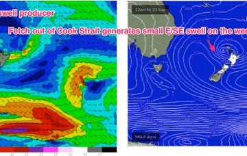
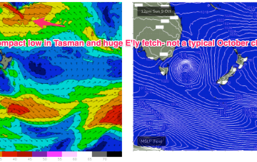
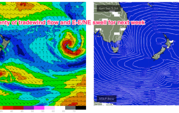
Monday, 10 October 2022
Plenty of E swell ahead this week courtesy of persistent, long, broad fetch of Tradewinds in the South Pacific slot, which has had windspeeds boosted on the northern flank by a tropical depression drifting south from Fijian longitudes.
/reports/forecaster-notes/south-east-queensland-northern-new-south-wales/2022/10/07/very-active
freeride76
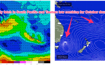
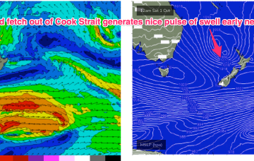
Friday, 7 October 2022
Mixed in with that will be 3ft E’ly swell, which marks the early stages of an extended swell event from the Coral Sea/South Pacific. A high pressure ridge should see mod/fresh S to SSE winds through the day, favouring the Points for clean conditions.
/reports/forecaster-notes/south-east-queensland-northern-new-south-wales/2022/10/05/very-un-spring
freeride76
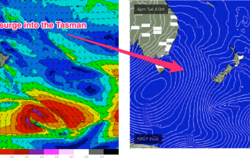
Wednesday, 5 October 2022
Strong fronts have already transited the Tasman Sea with some long period S-SSE swell pulses incoming. Those pulses will be concurrent in a more dominant building E/NE-NE windswell episode, through the rest of the week and into the weekend. Lots of action next week as both our Eastern and near Southern swell windows fire up.
/reports/forecaster-notes/south-east-queensland-northern-new-south-wales/2022/10/03/couple-small
freeride76
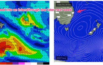
Monday, 3 October 2022
A much stronger high is moving into the classic La Niña slot- SE of Tasmania- where it will start to be squeezed by another approaching inland trough and complex low pressure system. That will see increasing E- NE winds come into play from mid-week with increasing levels of NE-E/NE windswell, especially on the Mid North Coast. Frontal progressions passing well to the south no longer have a strong surge into the Tasman but will send mid/long period pulses of S-SSE swell our way from mid week while a strong developing trade-wind flow will keep swell chugging away from the E into next week. A very active outlook for October.
/reports/forecaster-notes/south-east-queensland-northern-new-south-wales/2022/09/30/plenty-wind-and
freeride76
Friday, 30 September 2022
No great change to the weekend f/cast. Wind and swell regimens will be dominated by the low in the Tasman, which is now retreating towards the North Island with a large (1037hPa) high south of Tasmania. Pressure gradients do slowly ease over the weekend as the high relaxes over warm Tasman sea waters and the low sets up near the North Island.
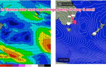
/reports/forecaster-notes/south-east-queensland-northern-new-south-wales/2022/09/28/sizey-s-se-swell
freeride76
Wednesday, 28 September 2022
We are now on the cusp of a low pressure event as a complex inland trough of low pressure forms a new low off the Central NSW Coast, backed by an advancing strong high pressure cell.
/reports/forecaster-notes/south-east-queensland-northern-new-south-wales/2022/09/26/small-surf
freeride76
Monday, 26 September 2022
Yet another inland trough forms an interior low mid-week, likely in Southern NSW, and this low is looking like a solid S-SSE swell producer as it moves offshore Wed/Thurs and becomes cradled by a strong high moving well south of the Bight. It’s not the type of pattern we would expect to see in late Sep, but with so much La Niña mediated troughiness in the Tasman, it’s just been a matter of time until something kicked off.

/reports/forecaster-notes/south-east-queensland-northern-new-south-wales/2022/09/22/fun-mixed-bag
freeride76
Friday, 23 September 2022
Models are now starting to firm on quite a significant swell producing system late next week as the low moves offshore and a strong high moving well south of the Bight offers a supporting pressure gradient squeeze on the Western flank of the low
/reports/forecaster-notes/south-east-queensland-northern-new-south-wales/2022/09/21/ne-windswell
freeride76
Wednesday, 21 September 2022
The complex low and huge trough line (extending across most of Australia!) are still tracking across the interior as forecast, with a high in the Tasman generating a NE flow across the majority of the Eastern Seaboard. The pressure gradient is tightened as the low approaches with an increase in NE winds and swell expected through the end of the week