There's no evidence to suggests any deviation away from the current regional trend for the east swell.
Primary tabs
/reports/forecaster-notes/south-east-queensland-northern-new-south-wales/2022/12/16/stacks-sustained
thermalben
Friday, 16 December 2022
/reports/forecaster-notes/south-east-queensland-northern-new-south-wales/2022/12/14/long-run-swell
thermalben
Wednesday, 14 December 2022
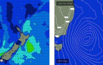
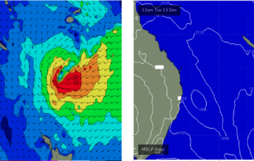
The main synoptic feature for the short term period is a developing complex Tasman Low that'll spin up east of Bass Strait overnight, and reach peak intensity on Friday, but actually remain active within our swell window until next Wednesday.
/reports/forecaster-notes/south-east-queensland-northern-new-south-wales/2022/12/12/active-period-the
thermalben
Monday, 12 December 2022
Lots of swell due this weekend from both the Tasman Low, and the sub-tropical low south of Fiji. But we'll see good waves prior to then too.

/reports/forecaster-notes/south-east-queensland-northern-new-south-wales/2022/12/09/solid-weekend
thermalben
Friday, 9 December 2022
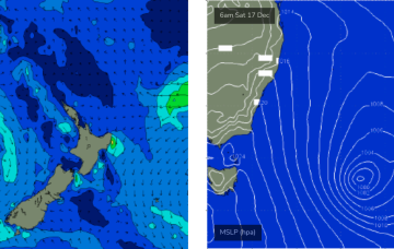
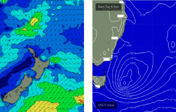
A deepening Tasman Low is currently parked midway between Tasmania and New Zealand, and southerly gales around its western flank reached maximum strength around lunchtime today.
/reports/forecaster-notes/south-east-queensland-northern-new-south-wales/2022/12/07/solid-round-south
thermalben
Wednesday, 7 December 2022
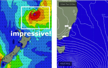
On Thursday and Friday, a new Tasman Low will develop off the Southern NSW Coast and move slowly eastwards. The latest model runs have strengthened this low, broadened its fetch and slowed its eastwards track.
/reports/forecaster-notes/south-east-queensland-northern-new-south-wales/2022/12/05/easterly-window
thermalben
Monday, 5 December 2022
Plenty of fun surf this weekend. For Northern NSW, that is.
/reports/forecaster-notes/south-east-queensland-northern-new-south-wales/2022/12/02/pumping-point
freeride76
Friday, 2 December 2022
A slow moving low pressure system is currently off the QLD coast generating plenty of size for the subtropics. Windspeeds along the southern flank are just a notch higher than modelled on Wed so we’ve seen a corresponding uptick in size.

/reports/forecaster-notes/south-east-queensland-northern-new-south-wales/2022/11/30/lots-action-ahead
freeride76
Wednesday, 30 November 2022
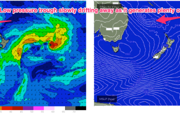
We are seeing the “schizoid” pattern now develop whereby a monsoonal trough is splitting off a low pressure trough along the CQ coast, supported by a high pressure belt from the Bight to the Tasman Sea, while fronts and a parent low are entering the lower Tasman. That is seeing a regime where both S swells and a developing E’ly swell event are both in play across most of the Eastern Seaboard.
/reports/forecaster-notes/south-east-queensland-northern-new-south-wales/2022/11/28/juicy-looking
freeride76
Monday, 28 November 2022
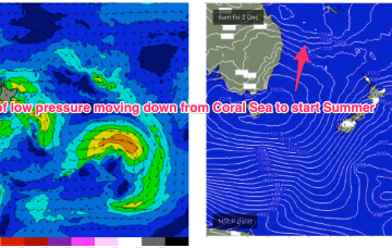
We’ve got an interesting looking pattern as we transition into Summer, with both active frontal systems transiting below the continent and a precursor monsoonal trough across the top end of Australia. A front pushing into the Tasman Sea and a deeper parent low bring S swell pulses this week while a trough of low pressure is expected to hive off the precursor monsoon trough mid week and sit in the Coral Sea later this week, bringing plenty of E swell for the Eastern Seaboard- especially favouring the sub-tropics for size and duration.
/reports/forecaster-notes/south-east-queensland-northern-new-south-wales/2022/11/25/coral-sea-fires
freeride76
Friday, 25 November 2022
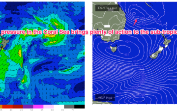
The more intense action will be in the sub-tropics with potential for a trough of low pressure to form off the CQ coast, potentially deepening into a hybrid sub-tropical low later next week. That looks to generate large swells for the SEQLD/NENSW Points for the most part.