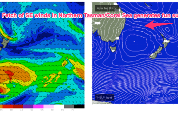
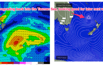
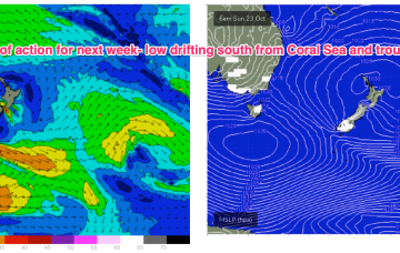
Charts have looked great all week with a low pressure system drifting in from the Coral Sea inside the North Island but the bad news is the low is now expected to track down the outside of the North Island with a major downgrade in swell potential.
Primary tabs
/reports/forecaster-notes/south-east-queensland-northern-new-south-wales/2022/11/04/downgraded-e
freeride76
Friday, 4 November 2022
/reports/forecaster-notes/south-east-queensland-northern-new-south-wales/2022/11/02/workable-s-swell
freeride76
Wednesday, 2 November 2022
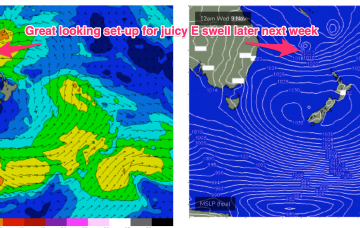
While they are not ideally positioned for maximal S swell production up the East Coast we are still looking at some useful S swell pulses over the rest of the week and into the weekend. Following that we are back to a typical summer pattern with plenty of fun E swell expected next week.
/reports/forecaster-notes/south-east-queensland-northern-new-south-wales/2022/10/31/mostly-tiny-week
freeride76
Monday, 31 October 2022
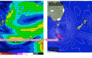
While we won’t get the full payload of S’ly swell from this system as the system gets shunted SW as it enters the swell window (NE would be ideal!) we’re still on track for a few usable S swell pulses this week mostly south of the border, with a trailing frontal system providing bigger S swell into and over the weekend.
/reports/forecaster-notes/south-east-queensland-northern-new-south-wales/2022/10/28/tiny-surf-ahead
freeride76
Friday, 28 October 2022
Our Autumnal run of surf and condition is now going to be replaced by a more late winter-style pattern, dominated by W’ly winds. A complex low pressure gyre is located over Tasmania with a trough having moved offshore from the NSW coast and a cold front pushing through Bass Strait today.
/reports/forecaster-notes/south-east-queensland-northern-new-south-wales/2022/10/26/easing-surf-the
freeride76
Wednesday, 26 October 2022
Our Coral Sea low is now sitting just NE of Tasmania where it has merged with an exiting interior low to form a large, slow moving low-pressure gyre. Troughs are still snaking across Australia with a long trough line extending from the low pressure gyre through inland NSW up towards QLD and then into the Northern Territory, expected to move offshore through today. More inland troughs approach the coast during the rest of this week, driving an unstable but basically NW’ly to W’ly biased wind flow across the f/cast region through the end of the week with easing swells.

/reports/forecaster-notes/south-east-queensland-northern-new-south-wales/2022/10/24/easing-swells
freeride76
Monday, 24 October 2022
A sub-tropical low which threatened SEQLD and NENSW over the weekend after it formed off the Capricorn coast is now steaming southwards at a fair clip, sliding along a high pressure ridge from a large (1035 hPa) high under Tasmania and dragging a strong fetch with it. The low is expected to merge with an inland low and horseshoe trough on the Gippsland Coast tomorrow forming a stalled low pressure gyre near Tasmania.

/reports/forecaster-notes/south-east-queensland-northern-new-south-wales/2022/10/21/dynamic-weekend
freeride76
Friday, 21 October 2022
Very dynamic weekend forecast ahead as a low pressure trough forms off the CQ coast today and forms a small surface low which drifts south to hug the coast over the weekend, accelerating away to the south through early next week.

/reports/forecaster-notes/south-east-queensland-northern-new-south-wales/2022/10/19/e-swell-now
freeride76
Wednesday, 19 October 2022
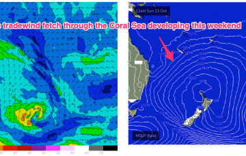
The onshore flow is enhanced into a deeper tradewind flow up in the Coral Sea, which gets a boost from a trough of low pressure expected to form off the Central QLD Coast this weekend before drifting south as a surface low, bringing sizey swell from the East and dynamic weather.
/reports/forecaster-notes/south-east-queensland-northern-new-south-wales/2022/10/17/few-small-windows
freeride76
Monday, 17 October 2022
As mentioned last week we have a weak, troughy pattern in the Tasman with a broad area of high pressure now moving over the area and yet another complex low pressure system moving East across inland Australia. A series of fronts are rapidly transiting across the Lower Tasman with some small S swell pulses en route. A last pulse of E swell generated in the South Pacific is due this week.
/reports/forecaster-notes/south-east-queensland-northern-new-south-wales/2022/10/14/slow-fade-out
freeride76
Friday, 14 October 2022
Surf-wise we’ll be on the gradual downslope of our extended E/NE swell event. Plenty of size, albeit increasingly inconsistent to carry us over the weekend.
