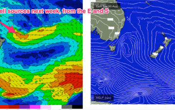
Strong trades through the central and northern Coral Sea over the weekend will gradually extend south by late Sunday, nosing just far enough into SE Qld’s eastern swell window to allow for a minor increase in short range E/NE energy.
Primary tabs
/reports/forecaster-notes/south-east-queensland-northern-new-south-wales/2022/08/26/slow-period-ahead
thermalben
Friday, 26 August 2022
/reports/forecaster-notes/south-east-queensland-northern-new-south-wales/2022/08/24/brief-spike-in-s
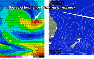
freeride76
Wednesday, 24 August 2022
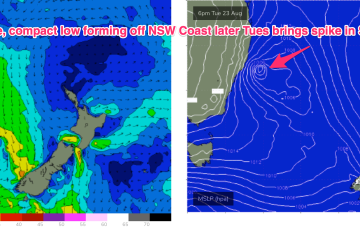
The current robust but compact low is driving near gales in a thin fetch adjacent to the Central/Mid North Coast, with a tail of weaker winds extending out into the Central Tasman, with the whole show moving eastwards quickly today. Another, much weaker front, pushes up the coast tomorrow before a large high pressure system sets up a ridge along the temperate to sub-tropical coast of NSW.
/reports/forecaster-notes/south-east-queensland-northern-new-south-wales/2022/08/22/long-range-e
freeride76
Monday, 22 August 2022
Synoptic charts this week look typical of a seasonal transition with mobile high pressure up at sub-tropical latitudes and a strong front poised to sweep into the Tasman with a robust low forming on the front line before rapidly shifting eastwards. Behind that typical seasonal pattern lurks signs of La Niña with a persistent trough line in the Coral Sea and a very strong high expected to track through the Southern Bight later this week.
/reports/forecaster-notes/south-east-queensland-northern-new-south-wales/2022/08/19/more-winter
thermalben
Friday, 19 August 2022
No major changes to the weekend outlook.
/reports/forecaster-notes/south-east-queensland-northern-new-south-wales/2022/08/17/more-the-same
thermalben
Wednesday, 17 August 2022
Looks like a great weekend of surf.
/reports/forecaster-notes/south-east-queensland-northern-new-south-wales/2022/08/15/couple-more-small
freeride76
Monday, 15 August 2022
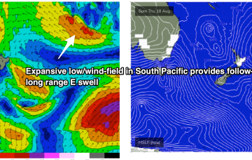
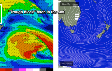
A trough line linked to the low extends from the Tasman Sea up into the Coral Sea past New Caledonia and over the next few days this trough deepens as it slowly moves East, activating an incredibly wide fetch of E to NE winds infeeding into it. We’re still looking good for a few days of quality surf from this source late in the week and into the weekend.
/reports/forecaster-notes/south-east-queensland-northern-new-south-wales/2022/08/12/days-small-clean
freeride76
Friday, 12 August 2022
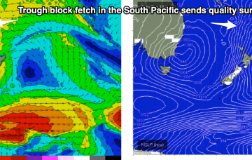
While this is happening a long trough line in the near South Pacific forms and deepens with a wind speeds increasing along a broad front due south of New Caledonia as they feed into the trough. Strong winds to gales feeding into the fetch through Tues-Thurs are expected to generate quality E/NE swell trains for the region.
/reports/forecaster-notes/south-east-queensland-northern-new-south-wales/2022/08/10/se-swell-eases
freeride76
Wednesday, 10 August 2022
The multiple fetches coming off a Tasman low near New Zealand anchored by a high just east of Tasmania are now starting to wane. Current ASCAT (satellite windspeed) passes show a weakening fetch of SE winds in the Central/Northern Tasman and a thin fetch of strong winds out of Cook Strait. That will lead to a slow easing trend through tomorrow, accelerating into Fri and the start of the week-end.
/reports/forecaster-notes/south-east-queensland-northern-new-south-wales/2022/08/08/multiple-pulses
freeride76
Monday, 8 August 2022
The building blocks are now in place for an active week of surf from the SE. A complex, multi-centred low is stationed over New Zealand with a strong (1029hPa) high located equidistant between Tasmania and the South Island offering excellent cradling support for the low.
/reports/forecaster-notes/south-east-queensland-northern-new-south-wales/2022/08/05/next-week-now
freeride76
Friday, 5 August 2022
Surf prospects are definitely looking juicier for the first half of next week with a much more substantial fetch of S-SSE winds set up on the Eastern side of the Tasman Sea as the decaying low reforms near New Zealand, aiming up some useful fetches towards the Eastern Seaboard.
