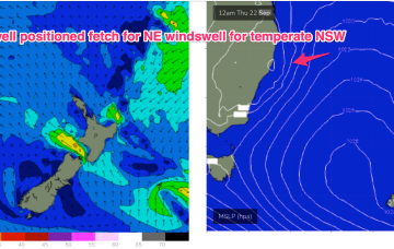
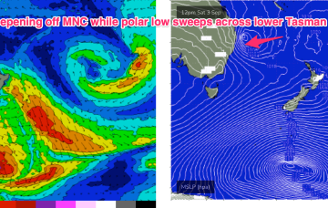
We have a typical looking Spring pattern with a weak high over the NSW interior and some flabby fronts passing South of Tasmania. An approaching trough series and inland low adds action mid-week as it tightens the pressure gradient with a more southerly located low, developing a N’ly fetch off the NSW Coast and another round of chunky NE windswell favouring the Mid North Coast for most size.
Primary tabs
/reports/forecaster-notes/south-east-queensland-northern-new-south-wales/2022/09/19/ne-windswell
freeride76
Monday, 19 September 2022
/reports/forecaster-notes/south-east-queensland-northern-new-south-wales/2022/09/16/small-weekend
freeride76
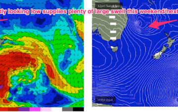
Friday, 16 September 2022
Still, no major change to the weekend f/cast. A complex low linked to multiple troughs and cold fronts is now approaching from SW of Tasmania. A main coastal trough linked to an Indian Ocean NW cloud band is clearing the area with a mostly offshore flow across the weekend and no major swell sources on tap.
/reports/forecaster-notes/south-east-queensland-northern-new-south-wales/2022/09/14/nly-pattern
freeride76
Wednesday, 14 September 2022
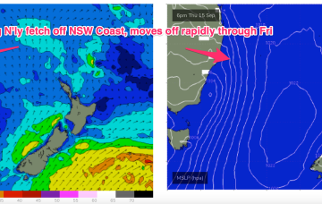
Typical Spring pattern with a slight La Niña/IOD twist unfolding at present. A large high is now moving into the Tasman, directing a N’ly flow along most of the Eastern seaboard. That flow intensifies in response to an approaching series of troughs and a complex low in the Bight.
/reports/forecaster-notes/south-east-queensland-northern-new-south-wales/2022/09/12/sly-pulses
freeride76
Monday, 12 September 2022
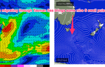
A strong, but decaying cold front tied to a mid-latitude low is pushing gales through a wide swathe of the lower Tasman, with a handy S swell now being generated for the region. A relatively weak high (1025hPa) is pushing though the Bight with a transitory ridge, quickly breaking down and tending N’ly mid week , before another mid-latitude low pushes through and brings a NW to W’ly flow across the weekend.
/reports/forecaster-notes/south-east-queensland-northern-new-south-wales/2022/09/09/small-slow
thermalben
Friday, 9 September 2022
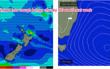
A longer period swell originating from storm force winds around the parent low is then scheduled to arrive across Northern NSW on Wednesday.
/reports/forecaster-notes/south-east-queensland-northern-new-south-wales/2022/09/07/last-hurrah-the
freeride76
Wednesday, 7 September 2022
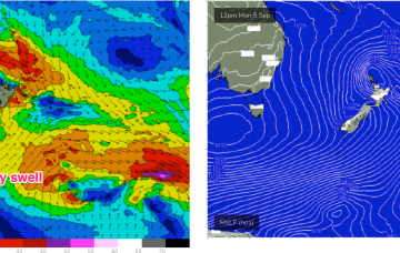
The Tasman low is out of the swell window and a large high is now moving over Tasmania to take up position in the Tasman Sea at a southerly latitude typical of the high pressure belt under the La Niña phase of the ENSO cycle. The high will move E with a N’ly flow rapidly developing as pressure gradients get tightened by an approaching front, complex low and trough line.
/reports/forecaster-notes/south-east-queensland-northern-new-south-wales/2022/09/05/few-nice-pulses
freeride76
Monday, 5 September 2022
Conditions should settle down quite quickly through the first half of the week as the rambunctious low which passed over Lord Howe Island on the weekend quickly scoots across to the North Island and beyond, generating some nice pulses of swell from fetches near the South Island and Cook Strait.
/reports/forecaster-notes/south-east-queensland-northern-new-south-wales/2022/09/02/large-and-windy
freeride76
Friday, 2 September 2022
Complex and dynamic weekend ahead, with an upper trough, surface trough and front forming a surface low in the convergence zone off the North Coast. This low is expected to rapidly deepen through Sat.
/reports/forecaster-notes/south-east-queensland-northern-new-south-wales/2022/08/31/small-surf-ends
freeride76
Wednesday, 31 August 2022
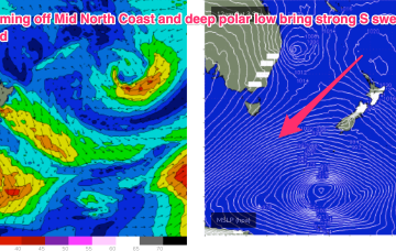
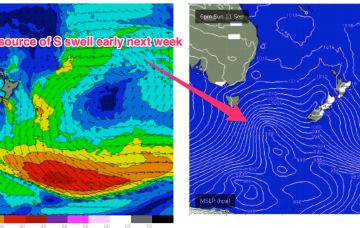
The current pattern- with weak high pressure drifting across Central NSW and a soft ridge along the coast- will be replaced in emphatic fashion by a much stronger front and trough on Friday, forming a surface low off the Mid North Coast, anchored by a monster high moving into the Bight at the same time. Well to the south of that set-up will be a deep polar low and associated fronts with severe gales to storm force winds generating long period S’ly swells to make landfall early next week.
/reports/forecaster-notes/south-east-queensland-northern-new-south-wales/2022/08/29/quiet-working
freeride76
Monday, 29 August 2022
Not a great deal of action on the charts to start the last week of Winter. A strong high (1040hPa) is on the other side of New Zealand but pressure gradients in the Tasman are weak, with minimal swell energy being generated from that source. Later in the week, Tradewinds do poke their head up over New Zealand and generate some useful E swell.