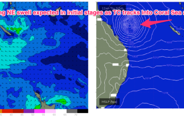
A convective cloud mass between the Solomon Islands and Vanuatu is expected to consolidate and deepen into a tropical cyclone by mid week, tracking back into the Coral Sea towards the tropical QLD coast before recurving and drifting Southwards through the Coral Sea and eventually towards the North Island. Solid swell from this system is expected across most of the Eastern Seaboard
Primary tabs
/reports/forecaster-notes/south-east-queensland-northern-new-south-wales/2023/02/06/lots-size
freeride76
Monday, 6 February 2023
/reports/forecaster-notes/south-east-queensland-northern-new-south-wales/2023/02/03/standard-summer
thermalben
Friday, 3 February 2023
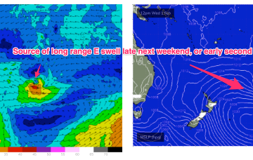
There’s a myriad of swell sources for next week.

/reports/forecaster-notes/south-east-queensland-northern-new-south-wales/2023/02/01/small-e-swell
freeride76
Wednesday, 1 February 2023
The unstable pattern continues with a small trough of low pressure lingering off the Central NSW Coast, linked to tropical cloud bands and moisture streaming in from the Northern Monsoon. This unstable, humid pattern lasts through the week before a winter-calibre mid-latitude low blasts a clearing W’ly flow across temperate NSW, with a S’ly change for the sub-tropics. Small, funky E swells maintain surfable conditions through the f/cast period.

/reports/forecaster-notes/south-east-queensland-northern-new-south-wales/2023/01/30/tricky-winds
freeride76
Monday, 30 January 2023
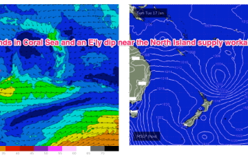
We’ve got a troughy, unstable synoptic pattern on our hands with monsoonal clouds and moisture extending from the Top End dawn to a trough off the NSW South Coast. Weak pressure gradients look to be with us for a few days as the trough lingers about the NSW Central/Mid North Coast, possibly forming a small low. Small pulses of E swell generated by fetches near the North Island supply some fun sized surf if you can work around the shifty winds expected this week.

/reports/forecaster-notes/south-east-queensland-northern-new-south-wales/2023/01/27/pattern-light
freeride76
Friday, 27 January 2023
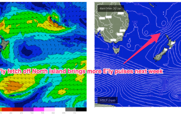
Weak high pressure is rapidly moving SE into the Tasman in the wake of yesterdays trough, which has stalled just north of the Hunter coast. E’ly fetches are still bubbling away near the North Island with more small E quadrant swell expected over the short/medium term.
/reports/forecaster-notes/south-east-queensland-northern-new-south-wales/2023/01/25/small-fun-e-swell
freeride76
Wednesday, 25 January 2023
The synoptic pattern over and surrounding Australia still has a strong La Niña signature with troughy low pressure areas in the Tasman Sea and an active monsoon trough across Northern Australia. High pressure on the other side of New Zealand is cradling areas of low pressure and maintaining a small, fun E swell signal.
/reports/forecaster-notes/south-east-queensland-northern-new-south-wales/2023/01/23/days-more-small
freeride76
Monday, 23 January 2023
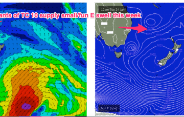
A troughy pattern exists through the Northern Tasman down to the South Coast with the remnants of TC 10P (named by JTWC but remained a cyclone for less than a day) drifting in a SW direction from out near New Caledonia as a weak sub-tropical low. A small low pressure cell near the South Coast is slowly drifting south leaving a variable flow in it’s wake across the f/cast region.
/reports/forecaster-notes/south-east-queensland-northern-new-south-wales/2023/01/19/plenty-small-fun
freeride76
Friday, 20 January 2023
In the Coral Sea a depression on the end of the Monsoon Trough is organising with a high likelihood of forming a tropical cyclone (TC Freddy) - this is looking like a handy swell producer for sub-tropical areas although no real size is expected as the system weakens as the swell producing fetch moves into the swell window.
/reports/forecaster-notes/south-east-queensland-northern-new-south-wales/2023/01/18/surfable-onshore
freeride76
Wednesday, 18 January 2023
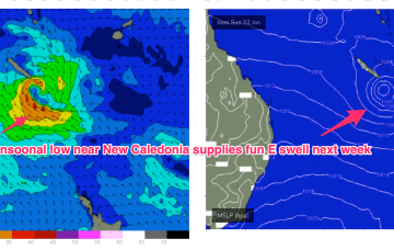
The Monsoon trough remains active but low-pressure systems budding off the trough line slide away to the SE in the absence of a strong supporting high, reducing surf potential until a system stalls near New Caledonia over the weekend/early next week.
/reports/forecaster-notes/south-east-queensland-northern-new-south-wales/2023/01/16/workable-pulses-e
freeride76
Monday, 16 January 2023
We’re in a bit of Groundhog Day pattern with another weak high moving into the Tasman, directing onshore winds across the Eastern Seaboard. These winds are tending NE through temperate NSW, more E’ly in the sub-tropics. Tradewinds in the Coral Sea will see continuing small, Summer surf until a S’ly change later in the week brings a new S-SSE swell pulse.