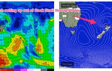
The evolution of the current pattern has sped up compared to Monday’s notes with high pressure drifting towards the South Island and weakening and a low centred around the North Island moving NE. A fetch off the top of the North Island is just scraping the edge of our swell window (better aimed at the sub-tropics).
Primary tabs
/reports/forecaster-notes/south-east-queensland-northern-new-south-wales/2023/06/07/spell-small-fun
freeride76
Wednesday, 7 June 2023
/reports/forecaster-notes/south-east-queensland-northern-new-south-wales/2023/06/05/fun-mix-swells
freeride76
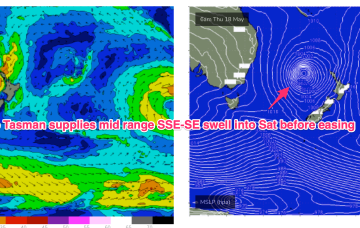
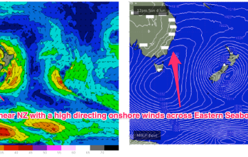
Monday, 5 June 2023
After a much more settled, stable May the first week of June is looking like a temporary back-slide into a more La Niña-esque pattern. A huge (1035hPa) high is sitting E of Tasmania with a low pressure system straddling New Zealand. The high is directing moist onshore winds right up the Eastern Seaboard, while the low has several swell producing fetches associated with it, albeit nothing too major.
/reports/forecaster-notes/south-east-queensland-northern-new-south-wales/2023/06/02/nice-pulse-s
freeride76
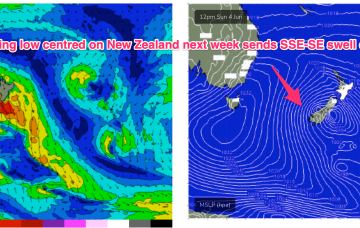
Friday, 2 June 2023
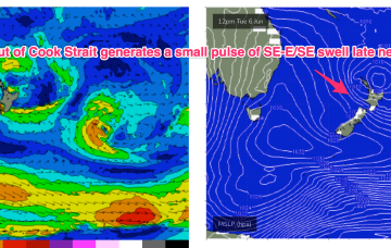
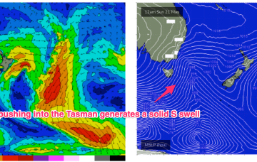
A front pushing aggressively NE into the lower Tasman on the weekend forms a low pressure centre which becomes slow moving near New Zealand early next week and this will be a co-main swell source for the week. The other source will be short range, peaky E’ly swell from a tradewind style fetch in the Southern Coral Sea.
/reports/forecaster-notes/south-east-queensland-northern-new-south-wales/2023/05/31/more-small-s
More small S swells with offshore winds into the weekend with some action from the E early next week
freeride76
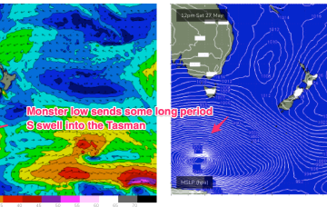
Wednesday, 31 May 2023
No great change to the current pattern with a large high sitting very far up (right up on the QLD/NSW border!) allowing free passage for cold fronts into the lower Tasman and a generally synoptic W’ly flow to continue across the region. Mostly long period S swell trains will continue to the be the dominant swell source until next week when a much more S’ly located high brings an onshore flow to most of the Eastern Seaboard. A trough of low pressure looks to briefly form off the Mid North Coast early next week before moving away quickly.
/reports/forecaster-notes/south-east-queensland-northern-new-south-wales/2023/05/29/very-tiny-in
freeride76
Monday, 29 May 2023
Very wintry looking synoptic chart as we exit Autumn with a large high moving in over the continent with active cold fronts tied to low pressure systems tracking into the Tasman Sea. That pattern will extend through most of the week before a high cell drops into the Tasman Friday, with stronger frontal activity expected over the weekend and into next week
/reports/forecaster-notes/south-east-queensland-northern-new-south-wales/2023/05/26/more-small-s
freeride76
Friday, 26 May 2023
The expected Tasman low forming in the wake of todays front really falls apart, forming instead a raggedy low pressure trough which moves away quickly to the NE overnight and into Sat. That leaves us with a scrappy, bog standard S swell for Sat
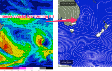
/reports/forecaster-notes/south-east-queensland-northern-new-south-wales/2023/05/24/more-typical
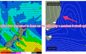
freeride76
Wednesday, 24 May 2023
As we come to the end of another (very!) active Autumn we’ve got a typical looking winter synoptic pattern unfolding with a dominant high drifting over NSW bringing settled conditions with a very active Southern Ocean storm track spawning a strong cold front which will impact the state on Fri. The front and an upper low are expected to form a surface low Fri off the Central NSW Coast. Compared to Mon’s notes this low is now expected to be weaker and much faster moving bringing a smaller, faster up and down in S swell.
/reports/forecaster-notes/south-east-queensland-northern-new-south-wales/2023/05/22/another-week-s
freeride76
Monday, 22 May 2023
A winter calibre front and low has now transited the Tasman, after generating a solid S swell for the Eastern Seaboard. Large high pressure (1032 hPa)is moving across inland NSW bringing settled conditions and light winds to the region, for the next few days.
/reports/forecaster-notes/south-east-queensland-northern-new-south-wales/2023/05/19/great-weekend
freeride76
Friday, 19 May 2023
We’re expecting plenty of fun waves for the weekend, Sat especially with our Tasman low stalling and deepening over the last 24-36hrs, slightly further away from NZ than modelled. That’s allowed E’ly quarter low end gales to develop in our swell window, even if aimed more directly further South.
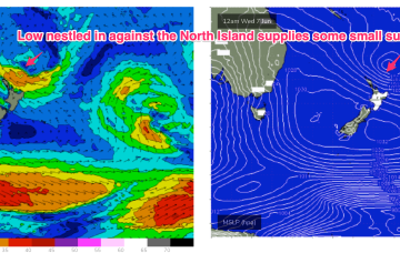
/reports/forecaster-notes/south-east-queensland-northern-new-south-wales/2023/05/17/plenty-fun-sized
freeride76
Wednesday, 17 May 2023
A small low formed off a coastal trough close to the QLD/NSW border yesterday and is now drifting close to Lord Howe Island, continuing to move SE-E/SE towards New Zealand. A tight pressure gradient between the low and a dual-centred high moving through the Bight is creating low end gales and strong winds on the SW flank of the low and generating S’ly swells up the Eastern seaboard, favouring NSW for most size.