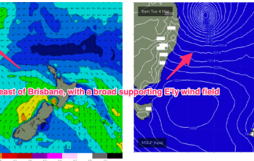
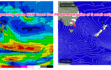
Our eastern swell window is about to become juiced up as a coastal trough across Northern NSW and a high in the Tasman Sea strengthen the trade flow across the Northern Tasman Sea.
Primary tabs
/reports/forecaster-notes/south-east-queensland-northern-new-south-wales/2025/03/24/coral-sea
thermalben
Monday, 24 March 2025
/reports/forecaster-notes/south-east-queensland-northern-new-south-wales/2025/03/21/grovel-over-the
freeride76
Friday, 21 March 2025
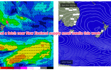
High pressure will be in the Tasman next week with ridge along the sub-tropics and a tradewind fetch enhanced by a long monsoon trough extending from the Indian Ocean across the north of the continent out to the South Pacific Island chains.
/reports/forecaster-notes/south-east-queensland-northern-new-south-wales/2025/03/19/plenty-fun
thermalben
Wednesday, 19 March 2025
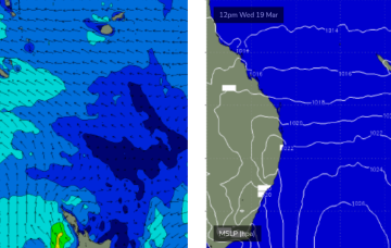
A small easterly trade swell will build through Thursday, offering some fun waves (banks permitting) throughout SE Qld and Northern NSW, before easing very slightly through Friday.
/reports/forecaster-notes/south-east-queensland-northern-new-south-wales/2025/03/17/windy-and-punchy
thermalben
Monday, 17 March 2025
The front responsible for today’s cool change isn’t really that beneficial for our immediate surf prospects.
/reports/forecaster-notes/south-east-queensland-northern-new-south-wales/2025/03/14/small-surf-over
freeride76
Friday, 14 March 2025
SW gales push through Bass Strait and off the Far South Coast Sun night and into Mon with the bulk of the frontal winds now likely to reach Coffs around 7am, Byron by lunch and the border around school pickup
/reports/forecaster-notes/south-east-queensland-northern-new-south-wales/2025/03/12/nothing-much
freeride76
Wednesday, 12 March 2025
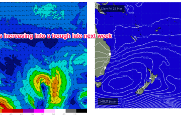
A weak trade flow in the Coral Sea now only looks capable of generating minor background E’ly swells. N’ly winds will increase over the weekend as a more significant trough and frontal system pushes into the Tasman next week, generating swells from the southern quadrant.

/reports/forecaster-notes/south-east-queensland-northern-new-south-wales/2025/03/10/ordinary-surf
freeride76
Monday, 10 March 2025
The whole synoptic pattern on the East Coast in the wake of Alfred is a moist onshore flow which looks to persist through into the mid week. A weak front races across the lower Tasman before reinforcing high pressure slips into the Tasman to reset the flow, albeit at a weaker level. Not a great deal of swell generated by any feature this week.
/reports/forecaster-notes/south-east-queensland-northern-new-south-wales/2025/03/07/north-the-storm
freeride76
Friday, 7 March 2025
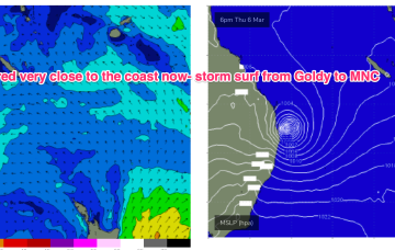
TC Alfred is maintaining intensity as a low end Cat 2 cyclone, as it moves slowly towards SEQLD at a walking pace. Gales to storm force winds are located across the SE and SW quadrants.
/reports/forecaster-notes/south-east-queensland-northern-new-south-wales/2025/03/05/areas-the-south
freeride76
Wednesday, 5 March 2025
Massive surf from the Moreton Bay Islands across the Gold Coast and down through Northern NSW will continue until the cyclone crossing, with much smaller surf on the Sunshine Coast and into temperate NSW. It’s been an epic event with a gnarly exclamation point expected as Alfred makes landfall.
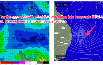
/reports/forecaster-notes/south-east-queensland-northern-new-south-wales/2025/03/03/buckle-tc-alfred
freeride76
Monday, 3 March 2025
TC Alfred (982hPa) is currently about 465 km east north-east of Brisbane and moving SE at 7kts holding intensity as a Cat 2 system continuing to generate pumping cyclone surf.