Coral Sea dynamics building towards a weekend climax

South-east Queensland and Northern NSW Surf Forecast by Ben Matson (issued Mon 24th Mar)
Features of the Forecast (tl;dr)
- Unusual long period S/SE swell building Tues PM, easing Wed (mainly across Northern NSW), could be punchy at some exposed spots though is a low confidence event
- Slowly building trade swell all week though with freshening SE winds, tending E/SE north of the border
- Complex scenario unfolding for the weekend with strengthening NE winds and a potentially large local swell, but also a chance that winds will swing offshore at some point (low confidence for now)
Recap
Most open beaches north from Yamba picked up small leftover east swell on Saturday to 2ft, easing to 1-2ft Sunday, and 1ft this morning. A small southerly swell glanced some parts of the Northern NSW coast on Saturday and Sunday with occasional 2ft sets though it was patchy in coverage. Winds have been generally light though mainly onshore.
This week (Mar 25 - 28)
Let’s kick off with our south swell window.
Tuesday’s unusual long period S/SE swell is still inbound for much of the NSW coast. ASCAT observations picked up very strong winds on Friday/Saturday however we need to keep in mind that the size of the fetch at low latitudes is actually much smaller (relative to the mercator map projection) so what looks impressive at first glance is actually somewhat exaggerated.
That being said, any long period energy with a touch of east has the potential to over perform (across Northern NSW), and because the models don’t see a lot of these kinds of events, they tend to underpredict wave heights. Our surf model is only expecting an afternoon peak in the 2ft range across most NSW beaches, whilst Steve’s notes from Friday (and my quick analysis this morning) suggest we could see much more size at south swell magnets, up to 3ft (with bigger surf in Southern NSW).
Of course, it goes without saying that this is a tricky, low confidence event so I’d be reluctant to pack the car overnight for a pre-dawn mission - but it’ll be well worth keeping an eye on things. I’m expecting an afternoon showing across the Mid North Coast - arriving late in the north - before size gradually eases through Wednesday.
Otherwise, our eastern swell window is about to become juiced up as a coastal trough across Northern NSW and a high in the Tasman Sea strengthen the trade flow across the Northern Tasman Sea.
This pattern will favour SE Qld for the most size - but also the most wind - building to 2-3ft through Tuesday afternoon and into Wednesday, though with smaller surf south from about Yamba from this source.
Local winds will freshen from the SE so it’s looking like protected points will be the only beneficiary (and they will be much smaller).
The broader pattern will intensify ever so gradually into Thursday and Friday which suggests an incremental increase in size, as conditions become a little more blustery away from sheltered locations. Winds are likely to become more E’ly across northern locations too, but remain SE south from about the Gold Coast.
There’s also a suggestion for a small surface intensification between the Sunny Coast and Bundaberg later Wednesday and Thursday that may provide a short term localised boost in size north of the Gold Coast (into Thursday) but we’ll keep an eye on that and update in Wednesday’s notes.
Either way, it’s looking like a very punchy but ultimately short period east swell that’ll build all week, in tandem with a heck of a lot of easterly quadrant wind. Hopefully it’ll start to move around some of these storm bars that built up during TC Alfred.
This weekend (Mar 29 - 30)
We’ve got a very tricky weekend ahead.
The deepening trough off the central Qld coast later this week is expected to move south, broadening and strengthening an E’ly tending NE fetch adjacent the SE Qld and Northern NSW coast.
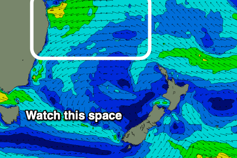
Right now there’s too much variability in the model guidance to be totally confident on surf prospects. It’s evolving with each model run and we are going to see more changes over the following days.
But there's every chance that the weekend will deliver punchy surf in the 6-8ft range at locations in the direct firing line.
The main thing I am trying to identify right now - without success, due to the conflicting model guidance - is whether we’ll see a small surface low form along the trough line, which would bring about a rapid change in wind direction to the west. There seems to be a general consensus that it’ll occur but the precise location is unsure - it could be anywhere from SE Qld down to Sydney.
Locations north of this development will see a rapid about face in conditions, but locations to its south would continue to experience driving NE winds.
Honestly, it’s one of those dynamic synoptic outlooks that we’re going to have to watch closely from model run to model run. I wouldn’t recommend making a final decision on when and where to surf until Friday.
Next week (Mar 31 onwards)
The outlook into next week will hinge solely around how the weekend’s synoptics evolve, so with the current high degree of uncertainty, there’s no point speculating about what may or may not happen.
See you Wednesday!
Comments
Eek. BOM have just forecast a tonne of rain Thu-Sun in Cooly. I wouldn't be parking under any of those already compromised Norfolk Pines
Nothing about the past few weeks surf wise has felt anything like autumn.
Black nor Easter….
This is a very typical summer pattern setup. I’m a big believer seasons are getting later hence Autumn won’t kick in proper until after Easter IMO.
Spring/Summer is getting longer rather than seasons getting later really. Winter is not persisting longer into Spring. IMO.
Unfortunately this.
Based on bushfires & local plants, the seasons appear to have advanced in the southeast.
Ocean temperatures are up, more rain is coming.
https://www.weatherzone.com.au/models/charts
Monsoon was late, next trough is moving down to to Victoria & Tazzie !
https://www.weatherzone.com.au/news/outback-deluge-to-cause-months-of-fl...
Yeah still very much in a summer setup.
One month through Autumn! I have a bad memory but I remember good surfs from... Late Feb last year?
I don't think there's been a decent run of surf since August last year.
Feb last year was so perfect. Consistent 3-4 foot east swell with nice 10 second periods for a month straight if i remember correctly.
I think we are just about in that tipping point of going into some epic autumnal conditions for the next few months. Lets hope April provides.
Not even a sniff of the long period S/SE swell north oy Byron. Cams didn't show anything as far south as Coffs either
Complete no show in the water here this morning.
Showed on the buoys, but not in the surf zone.
Ben, do you think there's any chance of those sat-tues northerlies swinging southerly, or possibly some morning offshores? That looks like a great swell ruined by some pesky wind.
Any News on Missing Surfer at Tallows ?
Board Found i Believe
"Inspector Jay Notaro is feared missing in the ocean near Byron Bay. A prominent South East Queensland police officer is feared missing in the ocean near Byron Bay after going for a surf, triggering a major search."
https://www.9news.com.au/national/search-for-missing-queensland-police-o...
Shit.
Terrible…
Dying for some good waves. Missed the surf for the last month with a broken toe. Looking pretty rubbish cos of the winds, monday maybe the next good day it seems.
You've missed nothing mate.
Take those Kirra days from Alfred out of the equation and it's been an incredibly poor start to autumn.
Hahaha yeh thats what i was hoping, i scored really good waves before the toe and its been rubbish since, except Kirra those 3 days.
Feel like the seasons are getting pushed back by 4-6 weeks, so hopefully autumn starts to light up soon.