Indonesia/Maldives forecast Mar 25

Indian Ocean Basin analysis by Craig Brokensha (issued Tuesday 25th March)
This week through next (Mar 26 - Apr 4)
The monsoonal surge and local westerly swell energy has come in at the lower end of the scale luckily, and we should see an inconsistent but slightly flukey S swell arriving into this afternoon.
This was generated by a late, strengthening low to the south-west of Western Australia late last week and performed well across their region. The swell looks best from about eastern Java through to Lombok, smaller further east.
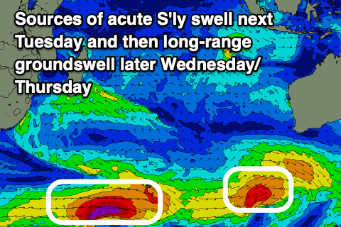
Of greater importance is the inconsistent but strong, moderate to large sized S/SW groundswell due into later tomorrow and Thursday.
As talked about last week, this swell was generated by a strong low that formed south-east of South Africa, with a great fetch of severe-gale W’ly winds pushing east across the Heard Island region, with a couple of bursts of embedded storm-force winds.
The low weakened while slowly turning towards Western Australia, with the groundswell due to kick strongly later tomorrow but likely to peak Thursday morning. It performed well across Western Australia, upping the confidence of the swell in Indonesia, with it due to offer large sets at the peak.
The swell then then ease slowly from Thursday afternoon, more noticeably into Friday.
Make the most of this swell as the remainder of the outlook is mostly small.
Besides a small mid-period S/SW swell next Tuesday afternoon/Wednesday there’s nothing of note longer term.
Local winds look best over the coming days and light N/NW tomorrow ahead of weak sea breezes, N/NW tending variable on Thursday.
From Friday it looks like W/NW winds will kick back in again, strengthening into the weekend as the swell fades.
In the Mentawais, strengthening NW winds look to develop across southern locations from today with weaker but moderate to fresh NW breezes further north. These winds should start to ease off from the weekend and tend more N/NW before going more variable next week as the surf bottoms out.
----------------------------------------------
Maldives:
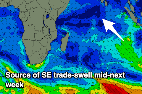
The SE trade-swell from the weekend is on the way out and unfortunately there’s no new energy due until the start of April, that being Tuesday next week.
A currently weak fetch of SE trades west of Western Australia should strengthen later this week and move west, producing a fun sized pulse of energy into the middle of next week, coming in moderate in size.
Across the southern atolls the inconsistent S’ly groundswell from the strong polar low that formed south-east of South Africa should arrive later today but peak tomorrow with strong sets across the magnets, easing slowly from Thursday.
Otherwise background swell pulses only look to come in at 2ft to occasionally 3ft through the weekend and next week, mixed in with the better SE trade-swell mid-next week.
Eastern Indonesia:
Small W’ly swell for the coming period, increasing into the weekend, fading slowly next week.
Small inconsistent S’ly groundswell for this afternoon to 3-5ft, easing tomorrow.
Moderate to large sized, inconsistent S/SW groundswell building tomorrow afternoon, likely peaking early Thursday to 6ft to occasionally 8ft across exposed breaks, easing slowly Friday.
Light N/NW winds tomorrow ahead of sea breezes, light N/NW tending variable Thursday. Strengthening W/NW winds from Friday and into the weekend easing slowly next week.
Uluwatu 16-day Forecast Graph/WAMs
Western Indonesia/Mentawais/South Sumatra:
Easing surf tomorrow morning.
Moderate to large sized, inconsistent S/SW groundswell building later tomorrow, peaking Thursday and reaching 6ft+ across exposed breaks, easing slowly Friday.
Strengthening NW winds across southern locations, moderate to fresh in the north. Easing winds on the weekend, tending more N/NW while becoming lighter to the north. Variable winds next week.
Mentawai 16-day Forecast Graph/WAMs
Maldives:
Small, inconsistent background SE trade-swell this week and weekend.
Moderate sized, inconsistent S/SW groundswell building later today, peaking tomorrow to 3-5ft across the southern atolls, easing slowly Thursday.
Moderate sized, inconsistent SE trade-swell building late Monday but more so Tuesday next week, reaching 4ft into the afternoon, holding Wednesday.
Variable winds this period, tending NW through the weekend and early next week, more NE through the middle of next week.
Comments
Latest notes are live.
Thanks Craig.
Head to Ments this Saturday.
Guessing out look not that great.
Ah, not the most active Andy but you'll get surf and winds look light which is a plus. Make the most of Sunday and more so Monday when a small mid-period S/SW pulse is due.
Cheers Craig.
Thanks for report!
Hope ya score andy-mac , & grateful for these reports Craig .
Thanks Supa.
Hopefully will get something. :)
Couple weeks in Bali after so should be due for a swell (fingers crossed) then.
And cheers Craig, great detailed reports.
Good forecast, there were 8 foot sets today in Bali
Awesome! Sorry next forecast will be next Tuesday.
there isn't anything worth forecasting until Monday anyway....
Didn’t get that big on NL , solid 5 ft in the morning, normally a bit smaller than ulu’s and occasionally has similar sized sets . Yesterday afternoon was 3-4 ft and dreamy conditions, lovely late arvo pulse with the big period new swell . Winds playing around now and waiting hopefully for it to swing offshore .
I doubt Ulu would have been anywhere near 8 foot
Well that was indeed a lovely swell . Consistent 4ft + on NL this morning with ok conditions around 7-10 am , really consistent after lunch although SSW wind made the surface rather choppy and bumpy but it was still fun .Yesterday arvo was beautiful conditions 4ft & out by myself until a couple joined me , then a full on thunderstorm with heavy rain made visibility near impossible . Bugger all people surfing was the highlight, locals busy with ceremonies and tourists bailing to Lombok and gillies to avoid Nyepi day . Looks like small surf & crap winds for a week then another swell. Look forward to your Tuesday report Craig .
Next weekend looks very good, it's a pity it's mudik, chasing it outside Bali will be close to impossible
Surfed wed,thurs,fri, waves best thurs afternoon on the low. Forecast spot on. 2.5 hr drive due to westerlies so intel appreciated
Thanks crew!