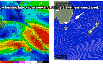
We’ve finally come to a low spot in the current La Niña phase we are in with energy being dialled right back this week. The high pressure belt is moving at a more typical northerly latitude over interior Australia and with weaker, more mobile high pressure moving over the interior and into the Tasman, we are looking at a period of N’ly biased winds with W’ly oriented fronts being quickly shunted across the Tasman.
Primary tabs
/reports/forecaster-notes/south-east-queensland-northern-new-south-wales/2022/08/01/weak-swells-nly
freeride76
Monday, 1 August 2022
/reports/forecaster-notes/south-east-queensland-northern-new-south-wales/2022/07/29/quiet-week-ahead
freeride76
Friday, 29 July 2022
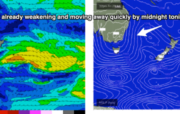
A much quieter period ahead as weak, spring-like conditions establish from Monday.
/reports/forecaster-notes/south-east-queensland-northern-new-south-wales/2022/07/27/more-energy-the
freeride76
Wednesday, 27 July 2022
One of the features of this current La Niña phase has been long-lived swell events as low pressure lingers in the Tasman Sea. This current event is typical of that pattern. We are now close to the end game as the low which started off the CQ Coast in the Coral Sea expends it’s last energy off the bottom of the South Island New Zealand.
/reports/forecaster-notes/south-east-queensland-northern-new-south-wales/2022/07/25/solid-surf-slowly
freeride76
Monday, 25 July 2022
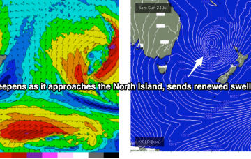
Lovely looking map this morning with the weekend’s Coral Sea low low lingering near the North Island, having intensified overnight. Current ASCAT (satellite windspeed) pass shows storm force winds embedded in a larger fetch of SE-ESE gales to severe gales aimed back (mostly) at NSW.
/reports/forecaster-notes/south-east-queensland-northern-new-south-wales/2022/07/22/swell-spike-in
freeride76
Friday, 22 July 2022
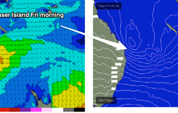
East Coast or hybrid low is now drifting towards Fraser Island, anchored by a huge high (1038hPa) just east of Tasmania. Thats directing gales towards SEQLD, and a broad fetch of E/SE winds as far south as the Hunter.
/reports/forecaster-notes/south-east-queensland-northern-new-south-wales/2022/07/20/all-hell-breaks
freeride76
Wednesday, 20 July 2022
By Friday we’ll see the Coral Sea low looking very impressive on the map and an E’ly fetch extend down into temperate latitudes. The low centre is expected to be NE of Fraser Island with E’ly gales aimed straight at SEQLD.
/reports/forecaster-notes/south-east-queensland-northern-new-south-wales/2022/07/18/couple-days-the-s
freeride76
Monday, 18 July 2022
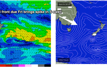
Surf comes from a wide variety of sources this week as a typical strong winter cold front gets shunted aside by a very La Niña looking synoptic pattern, more reminiscent of Feb/Mar than July.

/reports/forecaster-notes/south-east-queensland-northern-new-south-wales/2022/07/15/easing-weekend
thermalben
Friday, 15 July 2022
No change to the weekend trend outlook, with the current south swell easing rapidly both days.
/reports/forecaster-notes/south-east-queensland-northern-new-south-wales/2022/07/13/raw-s-swell
freeride76
Wednesday, 13 July 2022
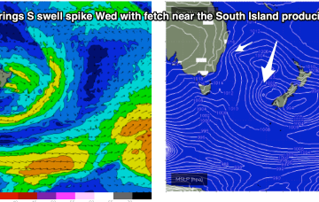
A trough line moving north-wards along the NSW Coast is spawning a surface low pressure system today, with the pressure gradient between the low and a high advancing through the interior creating a stiff S’ly flow along the coast.
/reports/forecaster-notes/south-east-queensland-northern-new-south-wales/2022/07/11/another-typical
freeride76
Monday, 11 July 2022
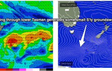
The remnants of the Tasman Low (ex ECL) are now drifting near the South Island, on top of a large high which is slowly moving out of the Tasman Sea. A high is approaching from the South Australian interior, with a trough expected to form off the coast later Tues and develop a broad, relatively weak low in the Central/Northern Tasman.
