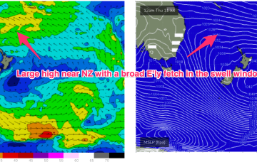
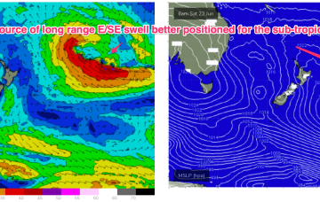
A trough in the Coral Sea accentuates an unstable SE flow in the sub-tropics and adds a local source of SE-E/SE swell into the mix north of Coffs. The high will be dominant right through into next week, as it slowly drifts into the Tasman, with some possibly juicy long range scenarios.
Primary tabs
/reports/forecaster-notes/south-east-queensland-northern-new-south-wales/2024/07/01/lots-se-wind-week
freeride76
Monday, 1 July 2024
/reports/forecaster-notes/south-east-queensland-northern-new-south-wales/2024/06/28/tidy-unseasonable
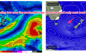
thermalben
Friday, 28 June 2024
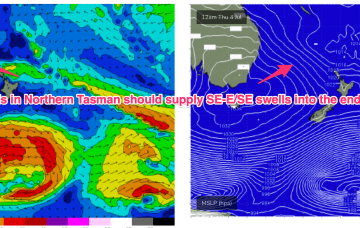
We’re looking at an unseasonable coastal trough developing off the SE Qld region, which is expected to generate solid, punchy short range E/SE swells for a few days.
/reports/forecaster-notes/south-east-queensland-northern-new-south-wales/2024/06/26/small-and-slow
freeride76
Wednesday, 26 June 2024
Our benign outlook runs into the weekend and right through it so there’ll be a few days better suited for rockfishing/inshore diving ahead.
/reports/forecaster-notes/south-east-queensland-northern-new-south-wales/2024/06/24/very-inconsistent
freeride76
Monday, 24 June 2024
A sub-tropical low north of the North Island scooted away to the SE over the weekend and as a result the long range E/SE swell is likely to be closer to 2ft than 3ft.
/reports/forecaster-notes/south-east-queensland-northern-new-south-wales/2024/06/21/small-raggedy-s
freeride76
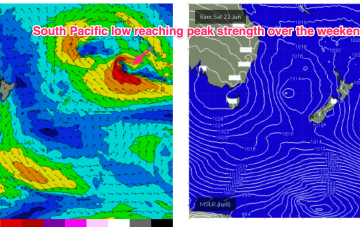
Friday, 21 June 2024
The system reaches peak strength over the weekend in Tongan longitudes, with a long fetch of E'ly winds, but it is moving away as it deepens, which limits swell growth.
/reports/forecaster-notes/south-east-queensland-northern-new-south-wales/2024/06/19/current-swell
freeride76
Wednesday, 19 June 2024
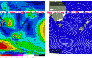
995 hPa low still sitting in the Central Tasman, but the supporting high pressure cell has slipped in underneath the low and as a result we’re seeing a slowly diminishing fetch and easing pressure gradients both in the Tasman and along the coastal fringe.
/reports/forecaster-notes/south-east-queensland-northern-new-south-wales/2024/06/17/low-in-the-tasman
freeride76
Monday, 17 June 2024
That low is expected to slowly drift and dissipate through the week, maintaining elevated surf through too mid-week with a very slow easing trend in place.
/reports/forecaster-notes/south-east-queensland-northern-new-south-wales/2024/06/14/and-down-and-the
freeride76
Friday, 14 June 2024
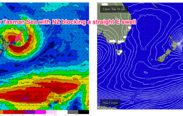
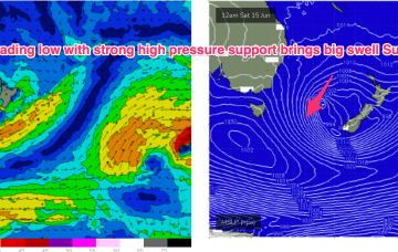
A secondary front pushing into the Tasman coalesces with a deepening low near New Zealand and the system then retrogrades back into the Tasman over an already active sea state delivering powerful S/SE swell before taking up residency in the Central Tasman for a few days next week with a slow, slow easing in big swells expected.
/reports/forecaster-notes/south-east-queensland-northern-new-south-wales/2024/06/12/days-strong-s
freeride76
Wednesday, 12 June 2024
Following that a secondary front coalesces with the primary front to form a complex Tasman which is expected to occupy the Tasman for a meaningful period of time, even retrograding back towards the East Coast over the weekend. The result will be multiple swell pulses from the S to S/SE (some very significant) right through until mid next week.
/reports/forecaster-notes/south-east-queensland-northern-new-south-wales/2024/06/10/strong-southerly
thermalben
Monday, 10 June 2024
Thursday is where things really get active. A deep Tasman Low will have been forming from Wednesday onwards, displaying a broad belt of S/SW winds that’ the entire length of the eastern seaboard, from the southern tip of Tasmania up to about Mackay.
