Indonesia/Maldives forecast Apr 3

Indian Ocean Basin analysis by Craig Brokensha (issued Thursday 3rd April)
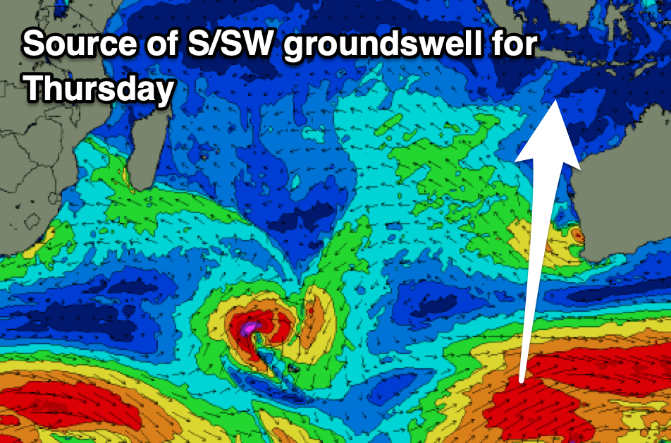
This week through next (Apr 3 - 11)
The surf is on the ease across the region but come later tomorrow, a new S/SW groundswell is due to start showing, with the bulk of the energy filling in and peaking through Saturday.
The source of this swell was a strong polar frontal system that projected towards Western Australia Sunday/Monday, with the swell building nicely through yesterday ahead of a peak early this morning.
Moderate + sized surf is due through all of Saturday, with the swell then easing through Sunday, further into Monday morning.
Our funky mid-period S’ly swell for later Monday but more so Tuesday morning is still on track, with a heat low forming off the Western Australian coast today, due to squeeze against a strong high south-west of their state, producing a strong fetch of S/SE winds that will persist all Friday before swinging more SE and away from us Saturday.
It still looks small to moderate in size, grading bigger further west and will produce an inconsistent SE swell for the Maldives later next week (discussed in more detail below).
Otherwise, small, background levels of S/SW groundswell are due into Thursday and Friday next week, generated by late forming polar frontal systems, south-west of Western Australia over the coming days.
The best for Thursday looks only small to moderate in size, fading Friday.

Looking longer term, and a strong, broad low that’s formed south-west of South Africa today should produce a moderate to large sized,but very inconsistent SW groundswell for next weekend, building Saturday afternoon ahead of a peak Sunday.
A distant fetch of gale to severe-gale W’ly winds will move slowly east while weakening over the coming days, with a secondary intensification due west of the Heard Island region, helping to produce inconsistent sets in the large size range. It’ll be very inconsistent and likely peak Sunday, but more on this Tuesday.
----------------------------------------------
Maldives:
The SE trade-swell from earlier in the week is now on the slow decline, but we should see a small boost out of the S/SE on Saturday/Sunday, generated by a fetch of S/SE winds on the western flank of Tropical Cyclone Courtney.
This energy will slowly ease into next week ahead of the inconsistent SE trade-swell from the heat low currently forming off Western Australia.
This swell only looks moderate in size and inconsistent, with it due into Thursday/Friday, easing from Saturday week.
S’ly swell pulses look generally small for the period ahead of the strong, long-range SW groundswell due into the end of the week.
This swell should build later Thursday but peak through Friday and come in moderate + in size before easing slowly next weekend.
Local winds look generally variable this period, tending W/SW-SW through the middle to end of next week.
Eastern Indonesia:
Moderate + sized S/SW groundswell kicking later tomorrow, peaking Saturday to 6ft across exposed breaks, easing Sunday.
Small-moderate sized mid-period S’ly swell for later Monday and Tuesday morning to 3-5ft across exposed breaks.
Small-moderate sized S’ly groundswell for later Wednesday but more so Thursday to 3-5ft across exposed breaks.
Mod-large, inconsistent SW groundswell building Saturday afternoon, peaking Sunday to 6ft to occasionally 8ft across exposed breaks.
Variable winds (locally offshore) ahead of weak sea breezes, with weak trades kicking in from the weekend through early next week.
Uluwatu 16-day Forecast Graph/WAMs
Western Indonesia/Mentawais/South Sumatra:
Moderate + sized S/SW groundswell building Saturday to 4-6ft across exposed breaks later, easing Sunday.
Small-moderate sized, mid-period S/SE swell for Tuesday to 3-5ft, easing Wednesday.
Small-moderate sized mid-period SW swell for later week.
Mod-large, inconsistent SW groundswell building Saturday afternoon, peaking Sunday to 6ft to occasionally 8ft across exposed breaks.
NW winds for the weekend, tending variable early next week then S/SE from Tuesday.
Mentawai 16-day Forecast Graph/WAMs
Maldives:
Small, inconsistent S/SE trade-swell for Saturday and Sunday to 3ft+, easing Monday.
Inconsistent SE trade-swell building later Wednesday, peaking Thursday/Friday to 4ft across exposed breaks, easing next weekend.
Small, inconsistent background S/SW swells this period either side of 3ft this period.
Moderate + sized, inconsistent S/SW groundswell building Thursday next week, peaking Friday to 4-5ft+ across the southern atolls (smaller Male).
Variable winds tending W/SW-SW mid-late next week.
Comments
Latest notes are live.
Bloody ripper mate.
Thanks Craig, just a quick query, when you say 'moderate + in size' for Maldives, what range is that? 3ft or so? Just wondering for future reference cos heading to Kandooma April 23rd. Cheers!
Hey David. It's down the bottom of the notes.
Ha! didn't read that far down, stopped after the first Maldives bit! Idiot award to me!!
@David.Green , I find the notes way more accurate than the model predictions. There’s been times when Craig notes have said 6-8 ft bombs and the models have it at 4-6 ft , can be the difference in what boards ya pack .
This didn't used to be the case, but in Bali, the models have been consistently under calling proper swells lately (vs their previous performance, which was very accurate for the swell magnets). Has the surf size forecast been altered (specifically for Uluwatu)?
@Craig , what’s happening on 13th 14th 15th ? Is that a glitch in the models and it’s combining swells or is it going to be BIG !
Good chance of a low/cyclone sitting between Indo and WA, right below you Supa.
Cheers fitz
Those lows/cyclone seem to be doing that every week for months.
Very annoying
@evo , east coast should be lighting up in a weeks time , could be worth a trip over . Plenty of options along that stretch of coast .