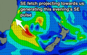
The source of our current swell weakened considerably over the last 24 hours so we’re looking at a steady decreasing trend through Tuesday and into Wednesday morning.
Primary tabs
The general swell trend should remain very large out of the south into Saturday morning, at a similar size seen this afternoon.
The synoptics look complex, but in reality the short term period has a relatively straightforward surf outlook. Big and windy from the south.
Synoptically, we’ll see a broad Tasman Low develop through Thursday that’ll end up displaying multiple low pressure centres. It looks like a complex, slow moving system that will occupy our swell window for quite some time.
The weekend forecast is relatively straight forward: we’re at the peak of this current event, so from tonight we’re looking at a slow decrease in size from the south, all the way through into Sunday evening.
The general trend is down steadily into Thursday, ahead an exceptional south swell for Friday.
We’re in the midst of a strong autumnal south swell pattern, with no signs of any let up in the near future.
Easing S'ly swell tomorrow, with a new pulse for Sunday, stronger Monday morning and then larger Tuesday morning and possibly Wednesday afternoon.
Good clean easing mix of S'ly groundswell and short-range S/SE swell tomorrow, with a large powerful long-period S'ly groundswell building Friday afternoon with light winds, easing Saturday. New S'ly groundswell for Sunday with favourable winds and lots more south swell next week.
Clean easing SE swell with good sized sets through the morning, smaller and bumpy into the afternoon. Mix of easing SE and new S'ly swells Wednesday with average winds, much better Thursday with a reinforcing S'ly groundswell and good winds all day. Large long-period S'ly groundswell building Friday afternoon as winds go onshore.


