Fun waves most of the week across the Mid Coast

South Australian Forecast by Craig Brokensha (issued Monday December 30th)
Best Days: Mid Coast now through Saturday, South Coast Saturday morning
Features of the Forecast (tl;dr)
- Moderate sized mid-period W/SW swell building tomorrow PM, with a stronger pulse for Wednesday/Thursday and then again later Thu/Fri
- Light E/NE-NE winds down South tomorrow AM, tending S-S/SW into the PM and then S/SE late
- Mod-fresh S/SE tending stronger S/SW winds Wed, S/SE later
- Fresh SE tending stronger S/SE winds Thu
- Light E/NE tending S/SE winds down South Fri, E tending S/SW on the Mid
- Light, local offshore winds Sat AM ahead of sea breezes
- Smaller Sun ahead of a new SW groundswell into the PM with strong S/SW-SW winds
Recap
The weekend started fun and clean off the South Coast with a drop in size from Friday under offshore winds, while the Mid Coast was choppy and a mess.
Sunday was a little more raw and less favourable though still fun in protected spots down South, while the Mid Coast also cleaned up but with the swell coming in too full early. Mid-late morning was the best of it with the dropping tide and 2ft sets under light winds, still good into the afternoon with weak sea breezes.
This morning the South Coast was looking much better with clean 2ft+ waves, with the Mid also continuing at 1-2ft but full with the early tide.

Small waves as the tide drops today
This week and weekend (Dec 31 - Jan 5)
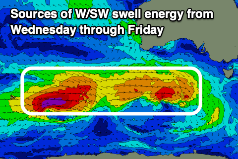
As touched on last week, we’ve got a great run of W/SW-SW swell energy for the coming week as a series of strong, back to back storms move in from the south-west of Western Australia.
An initial low that generated a great fetch of sub-gale-force W/SW winds is now pushing south of the Bight with an initial mid-period W/SW swell pulse due later tomorrow and Wednesday morning ahead of some better energy on later Wednesday/Thursday and then a third, additional groundswell pulse later Thursday/Friday.
The groundswell will be generated by the secondary low which is producing fetches of gale to severe-gale W/SW winds at a slightly more southern latitude.
Size wise the Mid Coast should build to 2ft tomorrow afternoon with Wednesday through Friday due come in at 2ft to occasionally 3ft on the favourable parts of the tide.
Middleton should come in around 3ft to occasionally 4ft on Wednesday with Thursday building a little more later ahead of a peak Friday morning to 4-6ft.
Looking at the local winds and tomorrow morning looks temporarily smaller with light E/NE-NE winds down South, offshore across the Mid Coast.
Afternoon sea breezes will merge with an incoming trough, shifting S/SE later across the Mid Coast while Wednesday will see moderate to fresh S/SE tending stronger S/SW winds, back to the S/SE across the Mid Coast on dark.
Thursday and Friday will be great across the Mid Coast with fresh SE tending strong S/SE winds, E’ly on Friday across the Mid Coast and tending E/NE down South which isn’t ideal but workable.
Saturday is the pick down South with a straight N’ly offshore wind (E across the Mid) and easing swell, though this will be slowed thanks to a small, tight low firing up on the backside of the current activity generating a reinforcing pulse of swell for the morning.
Middleton looks to ease from 3ft+ with 1-1.5ft waves across the Mid Coast.
Come Sunday a small low moving in from the west looks to bring a S/SW-SW change from dawn along with smaller surf in the morning, but a new groundswell is due into the afternoon/Monday.
The source will be a broader, stronger low tracking south-east through our swell window from later this week, but we’ll have a closer look at this Wednesday.
Comments
A bit like Habour Town on Boxing Day - you'll struggle to find a carpark on the Mid after 7am on Wednesday.
So true with carpark rage. The day of the surf forecast should come to an end, just publish a wide range of weather data and let individual punters work it out, or just catch the cams as you wake in the morning.