Plenty of swell this week but with tricky winds

Victorian Forecast by Craig Brokensha (issued Monday December 30th)
Best Days: Wednesday morning Surf Coast, selected spots to the east Friday, Saturday morning
Features of the Forecast (tl;dr)
- Smaller surf tomorrow with a S/SW breeze, freshening later (likely light W'ly early Surf Coast)
- Moderate sized mid-period W/SW swell Wed with a slightly stronger pulse Thu
- Strengthening SW winds Wed, lighter W'ly early Surf Coast
- Fresh S winds Thu
- Mod-large W/SW groundswell Fri, peaking through the day with moderate E/SE tending light E/NE winds ahead of sea breezes
- Easing W/SW swell Sat mixed with a moderate sized SW swell under N/NE winds to the east, N/NW to west ahead of sea breezes
- Building SW swell Sun with fresh SE winds
Recap
Ebbs and pulses of inconsistent W/SW swell energy has provided fun waves across the Surf Coast magnets all weekend and into today with 2ft to occasionally 3ft sets while other breaks have come in smaller. Conditions have been favourable each morning while there have also been a couple of options to the east.
The swell will ease slowly through the day ahead of freshening sea breezes.
This weekend and next week (Dec 31 - Jan 5)
Into this evening and tomorrow a weak trough will move through, bringing weak S/SW winds throughout the morning along with a drop in swell. The Surf Coast will likely see early W’ly winds but with a small 2ft of swell, lumpy/bumpy to the east.
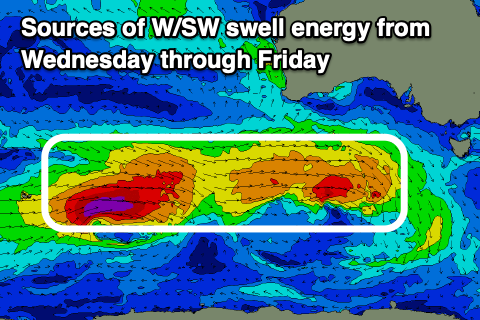
Into the late afternoon but more so Wednesday, our first pulse of W/SW swell should be starting to show, generated by a healthy low come frontal system moving in from the south-west of Western Australia over the weekend.
The front is now pushing towards us, south of the Bight with an initial mid-period W/SW swell pulse due Wednesday ahead of some better energy on Thursday and then a third, larger groundswell pulse on Friday.
Thursday’s pulse was generated by the earlier stages of the initial low, while a secondary stronger system tailing directly behind is generating a fetch of gale to severe-gale W/SW winds.
This system will weaken while pushing closer towards us over the coming days though maintain a decent strength until pushing up and into us through Wednesday.
Unfortunately this will bring strengthening SW breeze on Wednesday when the first pulse of swell fills in, though the Surf Coast will likely see early, light W’ly winds. Size wise the Surf Coast should be around 3ft with 4-6ft sets to the east, while Thursday’s pulse looks a bit better and to 3-4ft and 6ft respectively.
Winds will unfortunately swing straight S’ly on Thursday but ease off a little from Wednesday, coming in fresh.
Friday’s groundswell looks to offer stronger 4-6ft sets on the Surf Coast magnets as it peaks through the day with 6-8ft sets on the magnets to the east and winds will back off further and shift E/SE through the morning, though a period of lighter E/NE winds is due mid-late morning opening up options to the east for the experienced.
Saturday looks the pick of it though as the size starts to tail away and winds swing around to the N’th, locally offshore from the N/NE to the east and N/NW to the west ahead of mid-afternoon sea breezes.

The easing trend will be slow thanks to a small, tight low firing up on the backside of the current activity generating a reinforcing pulse of swell for the morning. The Surf Coast is still likely to be in the 3-4ft range with 6ft sets to the east, easing through the afternoon.
Come Sunday a trough may bring S/SE winds, spoiling a new, moderate sized pulse of SW groundswell that’s due to arrive into the afternoon.
The source will be a broader, stronger low tracking south-east through our swell window from later this week, but we’ll have a closer look at this and the local winds for Monday as it eases on Wednesday. The trough moving through Sunday looks to bring varying scenarios, though mostly likely onshore.
Comments
Late next week is going to cause some carnage at the popular breaks with masses testing their Christmas presents. Ha.
Craig any prospects for a wave on the surf coast second week of the new year? And.....with all of this SE wind, how do you see this impacting the Pier to Pub on the 11th?
RIP Mick Turner from Lorne. Ex Geelong captain and keen surfer down this way. Battled pancreatic cancer for a couple of years and it looked like he had it beaten. Was back surfing Lorne and Cathedral and looking fit. But the cancer came back with a vengeance. All round good bloke and will be missed by everyone who knew him.
I didn't mention another Lorne Point legend who passed away recently. Darren Powell. He was such a funny guy in and out of the water. Also missed by everyone who knew him. RIP.