S'ly swell regime with favourable winds
Sydney, Hunter and Illawarra Surf Forecast by Craig Brokensha (issued Wednesday 16th May)
Best Days: Thursday, Friday afternoon, early Saturday morning, Sunday, Monday, Tuesday morning, Wednesday
Recap
Yesterday saw pumping surf across the Sydney region at breaks handling the clean 4-6ft SE groundswell, which was a little raw early but settling mid-morning. A shallow S'ly change moved through the day with weaker sea breezes into the afternoon.
This morning the SE swell was back to 3-4ft, and a S'ly change just before dawn created average conditions, but winds swung back offshore for a few hours on the Northern Beaches, creating super fun surf again.
Today’s Forecaster Notes are brought to you by Rip Curl
This week and weekend (May 17 – 20)
These notes will be brief as Ben’s away today.
Today's change has generated a short-range S'ly swell that's filled in this afternoon while the SE energy backs away, and we'll see a stronger S'ly groundswell signal tomorrow morning from the earlier stages of this front as a polar low.
South magnets are due to come in at 3ft to occasionally 4ft, easing through the day as the short-range S/SE swell also eases.
 Winds look great through the morning for south magnets with a light W/NW offshore ahead of afternoon NE sea breezes.
A low point in swell is due Friday morning with leftover 2ft+ sets across south magnets and a morning W/NW offshore again, giving into a very weak S'ly change into the afternoon and possibly even variable across the coast.
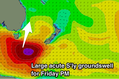
Our new large long-period acute S'ly groundswell is still on track, with a severe low generating a fetch of storm-force W'ly winds along the polar shelf.
Satellite observations of this low have been great and they indicate the system weakening ever so slightly while projecting east-northeast towards New Zealand this evening and tomorrow morning.
The swell should hit the buoys Friday morning with a 20s signal, with the bulk of the energy arriving into the afternoon and evening.
Expect south facing locations to kick to a large 5-6ft by dark ("The large groundswell is being under forecast by the wave models"), with 8ft bombs at deep water reefs and across the Hunter.
As touched on in Monday's notes, these long-period S'ly groundswells always do funky things and focus into some places and not into others, so expect to do a bit of driving if trying to maximise the swell potential off this system.
The swell will be easing into Saturday, dropping from 3-5ft across south magnets along with a dawn W/SW breeze, tending more SW through the morning and then S/SE into the afternoon as a front clips the south-east of the country.
This front will generate a fetch of SW gales south-east of Tasmania, through our southern swell window, generating a new long-period S'ly groundswell for Sunday, peaking through the afternoon.
We should see solid 4-5ft sets across south facing beaches, larger on the Hunter and with W/NW tending variable breeze.
This frontal system will likely signal the start of a prolonged period of S'ly groundswell energy as a strong node of the Long Wave Trough sits across the Tasman Sea, directing front after front up through our southern swell window.
The models are still shifting around regarding the timing and strength of polar fronts being projecting through our southern swell window, but there'll be no lack of swell next week. Check back Friday for the latest on this southerly swell regime.


Comments
Ive lost count in the last 2 years of how many very weak cold fronts arrive almost
the same time as a ground swell and these cold fronts have absolutely nothing
to do with the ground swell. All they do is mess up the perfect ground swell lines
with shitty onshore winds. Does my head in.
Well they usually are somewhat related.
Ie this front today spawned off the strong polar low bringing the groundswell tomorrow morning. Luckily Friday PM's swell looks to come with very little wind in the afternoon (fingers crossed).
What about a little teaser for mid next week? Looks like its going to sizey?
Still shifting about.
Why does the current "Surf Forecast" differ from these notes so much for friday (2-3 ft as opposed to 5-6ft friday arvo). Is it just not updated yet?
Ah, as stated in Monday's notes but missed here (I'll add)..
"The large groundswell is being under forecast by the wave models"
well, that was fun. 2-3 feet, nice and smooth. bit full with the tide by the time i got down there at the gentleman's hour.

i put new fins in the board. hand laid fibreglass 2+1 set up. lots of drive! felt great. big change from the small, plastic fins i've been using.
Nice, yeah I had an empty 3-4ft surf at a south magnet, insane.
I have that same setup in my hi-performance twin, goes so well!
Craig, do you still expect the long period South swell to hit Sydney northern beaches in time for a pre-sunset 1-2 hour session? Or do I just stay at work and wait for next week's swell? Not much exciting showing on the surf cams down the south coast.
It's say wait for the next events.
The swell has hit the Sydney buoys with peak periods of 19s, but there's no real size to it still. 3-4ft and inconsistent, mixed with a low tide and it's meh.
Thanks Craig. Who would have thought that $10/month gets me (near) real time webchat? Bargain.