Moderate, pulsey swells throughout the week; reasonable conditions abound

Sydney, Hunter and Illawarra Surf Forecast by Ben Matson (issued Monday 4th June)
Best Days: Tues: tricky winds, but good easing E/SE swells. Wed/Thurs: generally good conditions in the mornings, small swell combo increase from Wed PM onwards. Fri: easing swells with light offshore winds.
Recap: Large, windy waves held out across the weekend, reaching a peak around 8ft+ at exposed south swell magnets though smaller elsewhere due to the direction. Size eased throughout Sunday but was supplemented by a particularly strong SE thru’ E/SE groundswell late in the afternoon that held into this morning, with sets around 6ft. The weekend’s mainly S’ly winds veered W/SW for a period this morning but they’ve gone S/SW throughout the day again.
Today’s Forecaster Notes are brought to you by Rip Curl
This week (June 5 - 8)
The source of our current swell weakened considerably over the last 24 hours so we’re looking at a steady decreasing trend through Tuesday and into Wednesday morning.
Tuesday morning should still manage 3-5ft sets at exposed beaches (smaller at southern ends) and winds are looking a little dicey as a ridge maintains a southerly airstream about exposed spots. We should see isolated regions of early SW or even W/SW winds (such as the Northern Beaches) but this will probably be the exception rather than the rule. In any case, expect winds to veer more S’ly throughout the day again. Expect smaller surf to prevail throughout the day as the swell continues to abate.
Wednesday will see size temporarily bottom out into the 2-3ft range ahead of two new swells making landfall throughout the day - a small renewal of E’ly swell from a fetch exiting western Cook Strait today (separating NZ’s North and South Islands) but a secondary, slightly stronger S/SE swell is also scheduled to arrive, sourced from a front pushing through the SE corner of the Tasman Sea. It’s poorly aligned, but is quite broad and strong and should generate some 3ft+ sets through the afternoon at south swell magnets (interestingly, our wave mode is not resolving this pattern well, combining both swell trains together - so confidence isn’t high for this event).
These new swells are expected to reach a peak overnight and into Thursday morning with occasional 3-4ft sets (mainly north from Sydney to the Hunter coast) before size eases back throughout the day. With the S/SE swell being the most dominant swell train these days, exposed northern ends will see the most size, and it’ll be smaller at southern ends.
As for conditions - Wednesday morning’s temporary dip in size will be accompanied by light variable winds but theres a risk of developing E’y winds as a new ridge strengthens across the Northern Tasman Sea. The Sydney and Hunter coasts are at most risk of these winds developing into the afternoon, with lighter and more variable winds likely south from Sydney.
Thursday should then see early light winds tending N’ly and freshening. We’ll probably see a little bit of short range E/NE swell in the mix on Thursday too, sourced from the ridge.
All swell sources are then expected to ease into Friday with winds tending more NW, so we can look forward to small but fun peaky beach breaks to finish the working week.
This weekend (June 9 - 10)
Looks like a small weekend ahead, with a weak troughy pattern across the Tasman Sea unlikely to generate any favourable swell generating systems. Winds should be light so conditions are looking nice but at this stage both days look like a grovel-fest.
Next week (June 11 onwards)
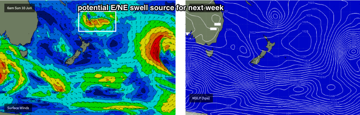
As mentioned on Friday, the end of the model runs have an unseasonable tropical low forming near Fiji this weekend and meandering north of new Zealand in a manner which may generate some small but useful E/NE swell for us next week. Let’s wait and see how things pan out over the coming days.
Otherwise, there is a suggestion that we’ll see the weekend’s trough throughout the Tasman Sea evolve into a low pressure system of some description early next week, though its usefulness from a Southern NSW perspective remains to be seen.
See you Wednesday!
Comments
Clean, defined lines at Avoca.

With a hint of strong'ness....
Today the swell finally lost it's strength. It felt much weaker than yesterday with half the size and power.
No fun!!
Still some nice lines at Manly!
