Lotsa wind, lotsa swell from a slow moving Tasman Low

Sydney, Hunter and Illawarra Surf Forecast by Ben Matson (issued Wednesday 30th February)
Best Days: Thurs thru' Sun: large though windy S tending SE swells. Mon/Tues/Wed: solid though easing SE swell with improving conditions.
Recap: Tuesday saw small fading swells from the the south with light winds. Today we’ve started off very small but strengthening S’ly winds have brought about an increase in short range S’ly swell to exposed south facing beaches this afternoon.
Today’s Forecaster Notes are brought to you by Rip Curl
This week (May 31 - June 1)
The synoptics look complex, but in reality the short term period has a relatively straightforward surf outlook.
Big and windy from the south.
A Tasman Low will form overnight in the central Tasman Sea, and a series of secondary lows and surface fronts wrapping around its western flank will maintain gale force S’ly winds parallel to the NSW Coast for several days. In fact it won’t be until later in the weekend or early next week that we start to see a notable improvement in surface conditions as winds begin to ease.
As for size, these southerly gales will steadily build swells through Thursday ahead of a more rapid and sizeable increase into Friday. Besides the size differential, the only other factor separating both days is that Friday will be more likely to see a S’ly airstream, whereas Thursday should see SW winds (even W/SW early at a few locations) though tending strong S/SW into the afternoon.
Thursday should reach 4-5ft at south facing beaches by the afternoon (smaller earlier, and smaller at beaches with less southerly exposure) but Friday is likely to push north of 8ft+ at these same exposed south swell magnets. Obviously, they won’t be surfable under the accompanying conditions so the only workable options will be inside sheltered southern corners.
This weekend (June 2 - 3)
Saturday is expected to continue Friday’s trend of strong to gale force S’ly winds and large S’ly swells somewhere in the 6-8ft+ range at south facing beaches. Protected southern corners and sheltered points will be your only workable option.
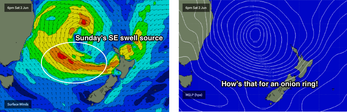
The Tasman Low will undergo some structural changes on Saturday, strengthening a new swell source (a broad E’ly fetch on its southern flank) and moving slowly to the east as we head into Sunday, which will cause local winds to weaken - though they’ll still be fresh gusty at times. Winds may also swing more to the SE though there’s a chance for early SW winds both days in a few selected locations.
The other main factor affecting Sunday will be a swing in the swell direction, as Saturday’s S’ly swell eases and is replaced with a fresh SE swell from the E’ly fetch developing across the lower Tasman Sea on Saturday. We may see a temporary dip in size throughout the morning, but this new swell should rebuilding exposed beaches back up into the 6ft to maybe 8ft range for the afternoon. However you will still need to aim for protected points and sheltered southern corners for the best options.
Next week (June 4 onwards)
As the Tasman Low slowly weakens into next week we’ll see a corresponding easing trend in the size department. That being said, early Monday should still be somewhere around the 6ft+ mark at south facing beaches (smaller elsewhere), easing throughout the day to 4-5ft by Tuesday morning and then 3ft by Wednesday morning.
Local winds will gradually ease throughout this period though we’re not expecting a synoptic offshore, so it’s likely that surface conditions will retain a degree of surface wobble. However it should be a vast improvement from what’s expected over the coming days.
Otherwise, there are no other major swell systems on the long term radar, just a few fronts in the Southern Ocean that should maintain small background S’ly swell into the end of next week. More on this in Friday’s notes.
Comments
Perfectly place Low but a bit weak perhaps? Imagine if it was more intense! Not complaining of course....
Hi Ben. Any chance of SW winds early Friday or Saturday mornings north of Newcastle?
Perfectly placed to pump wind onto the coast along with a shit swell. Should be so week it isn't even there.
Solid sets on the Cenny Coast this AM.
How big is Avoca now? Breaking level with the end of the point. Gotta be at least 8ft.
