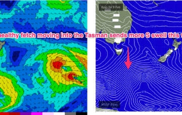
Plenty of swell for the period, initially from the southern quadrant, then north-eastern.
Primary tabs
/reports/forecaster-notes/eastern-tasmania/2024/02/07/great-mix-swells-the-coming-period
Craig
Wednesday, 7 February 2024
/reports/forecaster-notes/eastern-tasmania/2024/02/05/lots-pulses-the-s-ahead-some-them-sizey
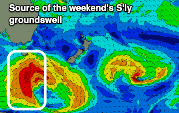
freeride76
Monday, 5 February 2024
To the south, a severe gale to storm force fetch off the ice shelf from a retrograding low under the South Island sends a rare S/SE groundswell up the Pipe, with another strong front/low late this week into the weekend expected to generate another pulse of S’ly groundswell late this week.
/reports/forecaster-notes/eastern-tasmania/2024/02/02/strong-s-swell-eases-over-the-weekend-few-swell
freeride76
Friday, 2 February 2024
A deep low with strong gales currently tracking in a NE direction SE of Tasmania justifies a slight upgrade in size for this weekend at S exposed breaks.
/reports/forecaster-notes/eastern-tasmania/2024/01/31/strong-s-swell-ahead-wintry-offshore-winds
freeride76
Wednesday, 31 January 2024
A much stronger front and parent low tracks NE into the lower Tasman late this week with a broad band of gales to strong gales expected to generate some strong S swell late this week and into the weekend.

/reports/forecaster-notes/eastern-tasmania/2024/01/29/small-bits-and-pieces-strong-s-swell-frisat
freeride76
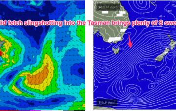
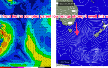
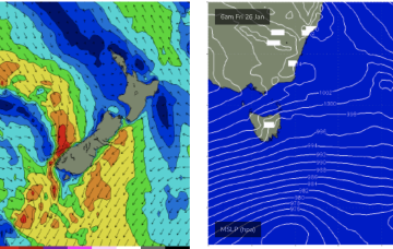
Monday, 29 January 2024
Fri should be a different story. Strong S swell expected to build Fri and extend into Sat as a front with gales to strong gales tied to a complex parent low drifts slowly through the far Southern Tasman.
/reports/forecaster-notes/eastern-tasmania/2024/01/26/nothing-much-short-term-possible-s-swell-later
freeride76
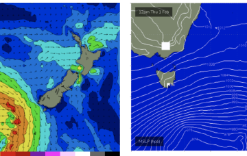
Friday, 26 January 2024
Into next week and not much happening to start the new week. High pressure moves quickly into the Tasman, with winds shifting NW-NE then SW-SE as a trough pushes through a shallow change.
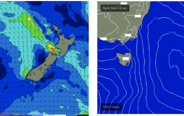
/reports/forecaster-notes/eastern-tasmania/2024/01/24/lots-smalltiny-days-ahead
freeride76
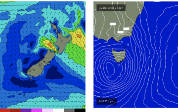
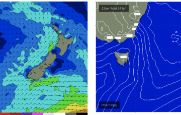
Wednesday, 24 January 2024
Absent that, with weak high pressure in the Tasman we’ve only got local wind swells to keep wave zones active this week, and into next. Let’s take a look.
/reports/forecaster-notes/eastern-tasmania/2024/01/22/fun-day-ne-windswell-mid-week-not-much-else-the
freeride76
Monday, 22 January 2024
NE winds off the South Coast extend down to Bass Strait and freshen o/night Tues into Wed with increasing NE windswell expected Wed.
/reports/forecaster-notes/eastern-tasmania/2024/01/19/fun-blend-s-and-small-ene-swell-over-the
freeride76
Friday, 19 January 2024
A compact low is tracking SE away from Tasmania with a nice slingshot fetch in the process of entering the Tasman adjacent to the Apple Isle. A retrograding fetch in the South Pacific is currently active and expected to send some fun surf our way over the weekend.
/reports/forecaster-notes/eastern-tasmania/2024/01/17/nice-mixed-bag-ahead-another-round-sizey-ne
freeride76
Wednesday, 17 January 2024
We’re midway through the current pattern with a high pressure cell near New Zealand directing fresh NE winds towards Tasmania, weakening trough in the Tasman and an approaching complex low SW of Tasmania.