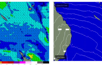
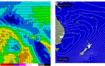
Tiny/flat surf look to build from Thurs as a new high pressure ridge builds up the QLD Coast. The high moves into the Tasman at roughly sub-tropical latitudes, with a reasonable ridge up the QLD Coast and some small, peaky swell developing likely into the 1-2ft range through Thurs.
Primary tabs
/reports/forecaster-notes/central-queensland/2023/07/10/few-small-waves-building-thurs-more-action
freeride76
Monday, 10 July 2023
/reports/forecaster-notes/central-queensland/2023/07/05/tinyflat-surf-another-round-fun-waves-mid
freeride76
Wednesday, 5 July 2023
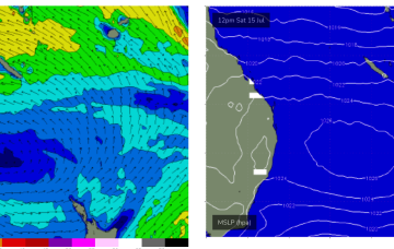
Still looking promising from mid next week as high pressure moves into the Tasman at a N'ly latitude and a SE surge builds up the QLD Coast.
/reports/forecaster-notes/central-queensland/2023/06/28/cq-will-see-some-surf-develop-sunmon
freeride76
Wednesday, 28 June 2023
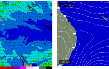
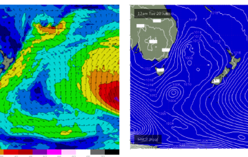
We still may see a trough/low develop off the Central QLD Coast and drift South, bringing building E/NE swells possibly Mon-Tues before the systems gets captured in the W’ly flow.
/reports/forecaster-notes/central-queensland/2023/06/23/flattiny-surf-potential next-week
freeride76
Friday, 23 June 2023
We’ll see some small background surf over the weekend and into next week from a trough and low in the South Pacific but only for exposed locations and only small, inconsistent 1-2ft surf tops.
/reports/forecaster-notes/central-queensland/2023/06/19/mostly-flat-just-tiny-wave-super-exposed
freeride76
Monday, 19 June 2023
None of these features generate swell for CQ, so we're looking at a typical winter flat spell.
/reports/forecaster-notes/central-queensland/2023/06/14/tinyflat-small-background-surf-later-next
freeride76
Wednesday, 14 June 2023
Tradewinds are dissipating in the Coral Sea with surf becoming tiny/flat into the weekend and most of next week.
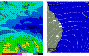
/reports/forecaster-notes/central-queensland/2023/06/07/just-few-small-waves-around-weekend
freeride76
Wednesday, 7 June 2023
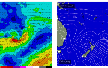
The weakening high is seeing a slow easing and contraction to the North of the tradewind fetch in the Coral Sea which has been supplying CQ with fun wave since the weekend.
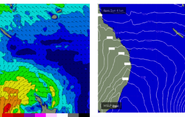
/reports/forecaster-notes/central-queensland/2023/06/05/size-peaks-mon-slow-easing-through-the-week
freeride76
Monday, 5 June 2023
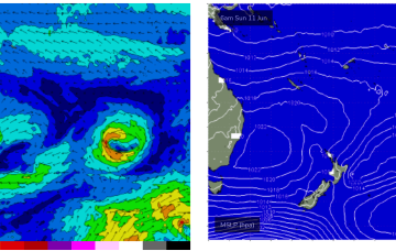
SE tradewinds in the Coral Sea remain widespread through the week, slowly contracting north and weakening into the end of the week. That should see a slow roll in size for CQ with surfable waves slowly easing back to tiny by Thurs.
/reports/forecaster-notes/central-queensland/2023/05/31/fun-waves-weekend-onwards
freeride76
Wednesday, 31 May 2023
No great change to the f/cast with a high pressure ridge already building across the QLD coast and set to be reinforced by a much, stronger high which moves SE of Tasmania (summer latitudes) over the weekend.
/reports/forecaster-notes/central-queensland/2023/05/25/tiny-surf-continues-chance-wave-later-next
freeride76
Friday, 26 May 2023
We’ve got a classic winter-style pattern happening at the moment with high riding high pressure, an active Southern Ocean storm track and pumping surf for Vicco, small surf wrapping into NSW and a flat spell for QLD. This winter pattern continues for most of next week but there is a little ray of hope on the horizon, ironically as we head into the first week of winter.