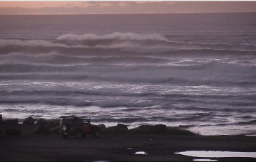
The trough block will break down over the weekend, to be replaced by a very strong high pressure system in the Tasman Sea
Primary tabs
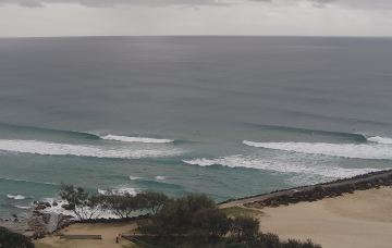
/reports/forecaster-notes/south-east-queensland-northern-new-south-wales/2023/04/21/great-run
thermalben
Friday, 21 April 2023
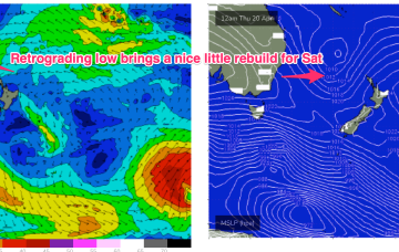
/reports/forecaster-notes/south-east-queensland-northern-new-south-wales/2023/04/19/plenty-more
freeride76
Wednesday, 19 April 2023
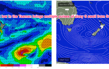
We still have the trough block pattern in place with the South Pacific low centre contracting away to the NE while a secondary low centre retrogrades back into he Tasman Sea. An anchoring high, is being shunted away with a trough and front expected tomorrow before a new dominant high moves in from the Bight.
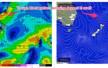
/reports/forecaster-notes/south-east-queensland-northern-new-south-wales/2023/04/17/extended-run
freeride76
Monday, 17 April 2023
The trough-block pattern set-up nicely over the weekend and we’re looking at a sustained run of swell from the Eastern quadrant. A long, angled trough with embedded low pressure centres on the Eastern flank is concentrating broad E-E/NE infeed fetches in our Eastern swell window.
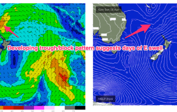
/reports/forecaster-notes/south-east-queensland-northern-new-south-wales/2023/04/14/last-the-s-swell
freeride76
Friday, 14 April 2023
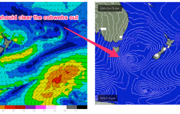
OK, we’re getting more clarity on the dynamic situation expected to unfold next week. The current small low off the North Coast quickly gets whisked away towards New Zealand and becomes enjoined in a long, NW-SE blocking trough pattern, which is expected to have more low pressure centres embedded in it next week.

/reports/forecaster-notes/south-east-queensland-northern-new-south-wales/2023/04/12/workable-s-sse
freeride76
Wednesday, 12 April 2023
The broad, complex Tasman low which generated large S swells is now positioned on the other side of New Zealand with a lingering fetch of SSE-SE winds under the South Island. A much smaller, cut-off low NW of Tasmania is linked via a trough line to TC Ilsa off the Kimberly Coast and is expected to drift into the Tasman Sea tomorrow bringing a fresh S’ly flow to round off the week. A dynamic trough blocking pattern is then expected to unfold in the medium term.
/reports/forecaster-notes/south-east-queensland-northern-new-south-wales/2023/04/10/solid-southerly
thermalben
Monday, 10 April 2023
The good news is that we're expecting light variable winds under a weak pressure gradient. The even better news is that there's a stack of more swell on the way.
/reports/forecaster-notes/south-east-queensland-northern-new-south-wales/2023/04/07/seasonal-shift
freeride76
Friday, 7 April 2023
A mid-latitude low slips East of Tasmania overnight and deepens rapidly as it merges with an incoming frontal system. The front brings a strong NW tending W’ly flow through Sat which will herald the start of a major S swell episode, favouring NENSW for size.
/reports/forecaster-notes/south-east-queensland-northern-new-south-wales/2023/04/05/great-e-swell
freeride76
Wednesday, 5 April 2023
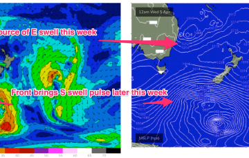
The big ticket item presently is the complex trough of low pressure off the Mid North Coast. Current ASCAT (satellite windspeed) passes show a proximate fetch of strong winds with embedded low end E’ly quarter gales aimed directly at the Mid North Coast.
/reports/forecaster-notes/south-east-queensland-northern-new-south-wales/2023/04/03/upgraded-outlook
freeride76
Monday, 3 April 2023
This will direct an E’ly fetch across a wide swathe of the Eastern seaboard from the sub-tropics down to the Sydney region. A small closed low forming in the trough then slowly retracts eastwards as we head into the Easter weekend. Winds are going to be a bit tricky but we’ll have plenty of E/SE-SE swell to play with this week as this fetch forms up.
/reports/forecaster-notes/south-east-queensland-northern-new-south-wales/2023/03/31/more-small-clean
freeride76
Friday, 31 March 2023
Eyes back to the E next week. The high in the Tasman and a blocking band of high pressure well to the south of the continent effectively annuls the southern swell window. With that shut down we’ll be looking to the East.
