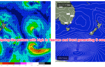
Unfortunately this strong cold outbreak now looks to stall just too far West (behind the swell shadow of Tasmania) to really deliver any strong S swell to the East Coast, before weakening as it moves into the Tasman Sea swell window proper.
Primary tabs
/reports/forecaster-notes/south-east-queensland-northern-new-south-wales/2023/03/06/spring-winds-most
freeride76
Monday, 6 March 2023
/reports/forecaster-notes/south-east-queensland-northern-new-south-wales/2023/03/03/dual-tcs-racing
freeride76
Friday, 3 March 2023
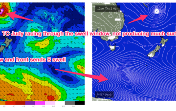
We may see a small amount of longer period E’ly energy as TC Judy briefly slows in the swell window. Nothing major, just a few 3ft sets. TC Kevin is now following the same path as TC Judy with just traces of E/NE-E energy added into the mix Sun/Mon.

/reports/forecaster-notes/south-east-queensland-northern-new-south-wales/2023/03/01/autumn-ordinary
freeride76
Wednesday, 1 March 2023
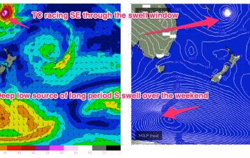
Lots of action on the charts but not much of it will translate to meaningful surf for the Eastern Seaboard. The tropics remains active with a monsoon trough and convective activity strewn across the Top End, while the edge of the trough in the South Pacific has spawned TC Judy, with another system behind it. Both of those systems are now modelled to track quickly SE through the swell window with no major swells generated.
/reports/forecaster-notes/south-east-queensland-northern-new-south-wales/2023/02/27/tease-the-tropics
freeride76
Monday, 27 February 2023
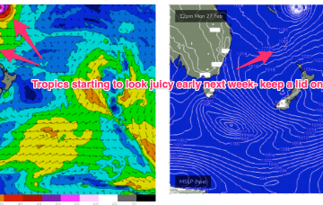
The troughy pattern will see rapid fire wind changes across temperate NSW this week and while all eyes are on the tropics it’s looking like a continuing tease with an expected tropical depression or TC moving quite quickly SE through the swell window with limited surf potential.
/reports/forecaster-notes/south-east-queensland-northern-new-south-wales/2023/02/24/small-fun-waves
freeride76
Friday, 24 February 2023
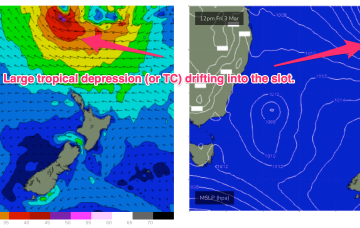
Models are now firming on a large tropical depression (possibly a TC) drifting southwards into the slot between New Caledonia and the North Island from mid next week. A broad, slow moving area of E’ly low end gales is likely on the southern flank of this system, initially favouring the sub-tropics, but radiating down to temperate NSW through next weekend.
/reports/forecaster-notes/south-east-queensland-northern-new-south-wales/2023/02/22/continuing-small
freeride76
Wednesday, 22 February 2023
Strong high pressure (1035 hPa) is now moving SE of Tasmania with an embedded trough along the advancing ridge ramping up wind speeds from the SSE-SE into the 20kts+ range. Conditions should settle as the high moves into the Tasman and weakens and the ridge relaxes through the end of the week. The high is augmenting an existing SE-ESE tradewind fetch through the Northern Tasman and Coral Seas and maintaining small E-SE swell.
/reports/forecaster-notes/south-east-queensland-northern-new-south-wales/2023/02/20/building-surf
thermalben
Monday, 20 February 2023
We've got some waves on the way, but conditions are looking a little average to be honest. There'll be waves but it won't be epic.
/reports/forecaster-notes/south-east-queensland-northern-new-south-wales/2023/02/17/ordinary-weekend
thermalben
Friday, 17 February 2023
OK first up, we've got some small, user-friendly east swell on the way, courtesy of a building ridge across the northern Tasman Sea, stretching out towards a small troughy feature N/NE of New Zealand on Sunday.
/reports/forecaster-notes/south-east-queensland-northern-new-south-wales/2023/02/15/small-mixed-bag
freeride76
Wednesday, 15 February 2023
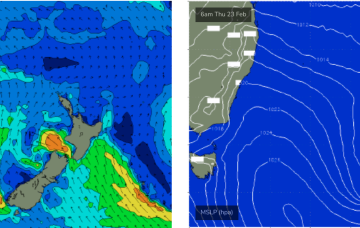
Ex TC Gabrielle (SS) is now on the eastern side of the North Island with swell generating winds also in the swell shadow of the North Island. A weak (1017HPa) high is covering most of the Tasman Sea with an active monsoon trough still supplying plenty of tropical moisture and instability across Northern Australia. Remnants of a trough near the South Island have set up a weak, off-axis fetch back into the Tasman Sea. It all spells a much quieter period of surf ahead.

/reports/forecaster-notes/south-east-queensland-northern-new-south-wales/2023/02/13/ex-tc-gabrielle
freeride76
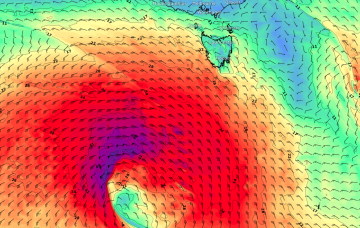
Monday, 13 February 2023
Ex TC Gabrielle is still the main game as far as swell production goes. The former cyclone is now a large sub-tropical storm (SS) slow moving near the top of the North Island. Current ASCAT (satellite windspeed) passes show a broad but short fetch of gales to severe gales extending off the west coast of the North Island, slightly off axis for the East Coast but maintaining a strong swell regime in the short term.
