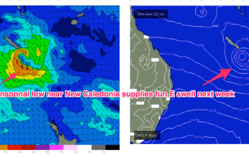
The Monsoon trough remains active but low-pressure systems budding off the trough line slide away to the SE in the absence of a strong supporting high, reducing surf potential until a system stalls near New Caledonia over the weekend/early next week.
Primary tabs
/reports/forecaster-notes/south-east-queensland-northern-new-south-wales/2023/01/18/surfable-onshore
freeride76
Wednesday, 18 January 2023
/reports/forecaster-notes/south-east-queensland-northern-new-south-wales/2023/01/16/workable-pulses-e
freeride76
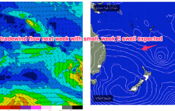
Monday, 16 January 2023
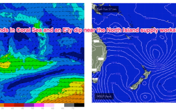
We’re in a bit of Groundhog Day pattern with another weak high moving into the Tasman, directing onshore winds across the Eastern Seaboard. These winds are tending NE through temperate NSW, more E’ly in the sub-tropics. Tradewinds in the Coral Sea will see continuing small, Summer surf until a S’ly change later in the week brings a new S-SSE swell pulse.
/reports/forecaster-notes/south-east-queensland-northern-new-south-wales/2023/01/13/small-fun-summer
freeride76
Friday, 13 January 2023
We’ve got a weak, blocking pattern with high pressure (1025 hPa) right smack bang in the middle of the Tasman directing an onshore flow along the Eastern Seaboard. NE across Temperate NSW and SE-E in the sub-tropics. Warm SST (sea surface temperatures) are helping morning land breeze development so conditions should be relatively clean through the early sessions.
/reports/forecaster-notes/south-east-queensland-northern-new-south-wales/2023/01/11/bust-out-the
freeride76
Wednesday, 11 January 2023
An insipid Summer blocking pattern is now setting up as a weak high (1019 hPa) moves East of Tasmania and becomes semi-stationary in the Central/Lower Tasman. That will see a short/medium term pattern of onshore winds and small summer surf becoming established.
/reports/forecaster-notes/south-east-queensland-northern-new-south-wales/2023/01/09/fun-beachies-week
freeride76
Monday, 9 January 2023
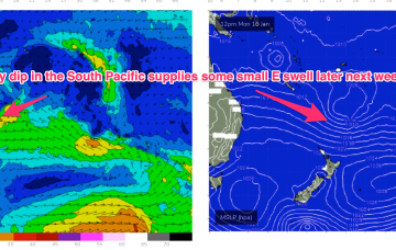
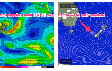
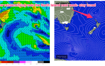
We currently have a weak, troughy pattern in the Tasman Sea, with continuing instability across the tropics in the wake of an active, monsoon pattern. High pressure is expected to drift south of Tasmania this week, with a typical Summer SE wind pattern becoming established. Remnants of low pressure near New Zealand are offering up minor fetches out of Cook Strait (currently) and near the South Island which will supply a few small pulses of swell this week.
/reports/forecaster-notes/south-east-queensland-northern-new-south-wales/2023/01/06/easing-surf-over
freeride76
Friday, 6 January 2023
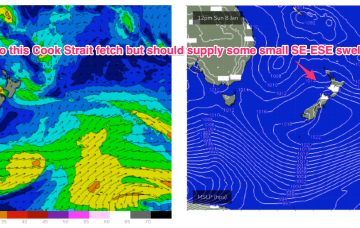
Generally speaking the leftover E’ly flow in the South Pacific looks weaker and less persistent and thus residual E’ly swell will likely fade in the mix faster than Wed’s notes suggested.
/reports/forecaster-notes/south-east-queensland-northern-new-south-wales/2023/01/04/surf-easing-now
freeride76
Wednesday, 4 January 2023
After a very slow moving synoptic pattern in the Xmas-New Years week we are finally seeing some movement as the tropical low which hived off the monsoon trough now journeys into the Southern Tasman, leading to easing swells across the region, where it will merge with a surface trough currently working it’s way north along the NSW Coast.
/reports/forecaster-notes/south-east-queensland-northern-new-south-wales/2023/01/02/winds-easing-days
freeride76
Monday, 2 January 2023
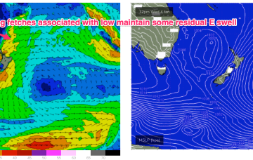
A tropical low which hived off the monsoon trough and which has been providing days of chunky E swell to sub-tropical regions is now, finally, on the move. Compared to model runs the system has been much more slow moving than f/cast- which is maintaining plenty of strong E swell across our sub-tropical region.
/reports/forecaster-notes/south-east-queensland-northern-new-south-wales/2022/12/30/days-more-surf
freeride76
Friday, 30 December 2022
No change to the weekend f/cast. E/NE swell across our region continues as the main body of the fetch remains aimed at sub-tropical targets. The high in the Tasman is maintaining a moderate onshore SE flow which is favouring the protected Points.
/reports/forecaster-notes/south-east-queensland-northern-new-south-wales/2022/12/28/days-strong-e
freeride76
Wednesday, 28 December 2022
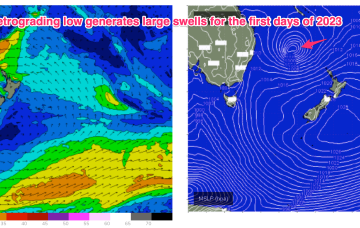
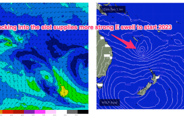
A dual-centred high straddles New Zealand with an elongated monsoonal low pressure trough located in the Coral Sea and extending into the near South Pacific. This is creating a long and broad E’ly fetch which is slowly extending southwards. As we near the end of the week, a more discrete surface low hives off the end of the monsoonal low pressure trough and retrogrades back into the Tasman Sea as it intensifies, generating large E’ly swells over the last days of 2022 and first days of 2023.