Monster high pressure approaching WA longitudes, high pressure over the NE of he country and Coral Sea and a series of cold fronts penetrating well into sub-tropical latitudes. A massive NW cloud band is drawing moisture in from the Indian Ocean and Arafura Sea via inland troughs.
Primary tabs
/reports/forecaster-notes/sydney-hunter-illawarra/2023/06/28/lots-s-swell-pulses-ahead-enough
freeride76
Wednesday, 28 June 2023
/reports/forecaster-notes/sydney-hunter-illawarra/2023/06/26/much-more-active-outlook-week-and-next
freeride76
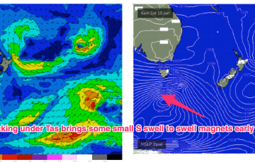
Monday, 26 June 2023
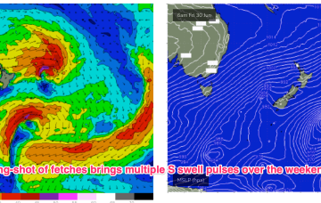
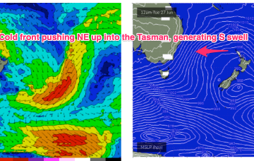
High pressure sitting up at sub-tropical latitudes is allowing a very active series of fronts to penetrate NE into the Tasman Sea. A very slow moving monster high tracking into WA longitudes is anchoring a sustained SW flow as the fronts ride up it’s extended flank from the Southern Ocean into the Tasman. We’ll see multiple S swell pulses from this set-up, becoming stronger over the weekend.
/reports/forecaster-notes/sydney-hunter-illawarra/2023/06/23/small-mixed-bag-the-weekend-plenty-the
freeride76
Friday, 23 June 2023
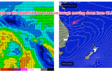
High pressure over the continent and off the QLD Coast is still supplying ridging which is now being strengthened by the next series of troughs and fronts. That will see another episode of W’ly quarter winds over the weekend, with patches of NW winds embedded in the flow.
/reports/forecaster-notes/sydney-hunter-illawarra/2023/06/21/next-week-now-looking-much-more-active
freeride76
Wednesday, 21 June 2023
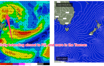
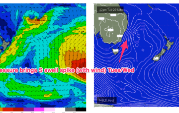
Looks like a much more active period ahead now, with strong frontal intrusion into the Tasman Sea and plenty of directional S swell ahead.
/reports/forecaster-notes/sydney-hunter-illawarra/2023/06/19/s-swell-spike-plenty-wind-eases-quickly
freeride76
Monday, 19 June 2023
High pressure over the continent its still ridging along it’s Southern flank with a westerly belt creating flat, groomed conditions. A deep, compact low is well SW of Tasmania, weakening as it enters the lower Tasman. A decaying front linked to the low spawns a broad area of low pressure in the Tasman tomorrow and then lingers in the Tasman for most of the week.
/reports/forecaster-notes/sydney-hunter-illawarra/2023/06/16/very-quiet-winter-continues-only-brief
freeride76
Friday, 16 June 2023
OK, the continent is covered in high pressure, now drifting out over NSW into the Tasman and right across our wide swell window we’ve got very placid sea states leading to a continuation of small, weak surf.

/reports/forecaster-notes/sydney-hunter-illawarra/2023/06/14/small-s-swell-thurs-otherwise-tiny-surf
freeride76
Wednesday, 14 June 2023
We’re midway through a pretty sleepy week, swell-wise. A high pressure cell is drifting across the interior of the continent with a trough/front connected to a high riding low pushing East of Tasmania through today. That's driving a mod/fresh synoptic W’ly flow across most of NSW and extending up into the sub-tropics.
/reports/forecaster-notes/sydney-hunter-illawarra/2023/06/12/slow-week-and-half
Craig
Monday, 12 June 2023
The coming week and a half are very slow swell wise.
/reports/forecaster-notes/sydney-hunter-illawarra/2023/06/09/small-flukey-swells-ahead-mostly
freeride76
Friday, 9 June 2023
A quiet start to next week is still on the cards- in fact the whole of next week now looks fairly subdued as a complex low becomes slow moving and drives a mostly offshore flow up the Eastern Seaboard.
/reports/forecaster-notes/sydney-hunter-illawarra/2023/06/07/fun-peak-in-surf-tomorrow-spell-small
freeride76
Wednesday, 7 June 2023
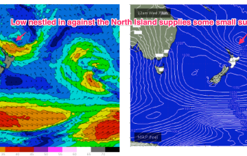
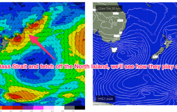
The evolution of the current pattern has sped up compared to Monday’s notes with high pressure drifting towards the South Island and weakening and a low centred around the North Island moving NE. A fetch off the top of the North Island is just scraping the edge of our swell window (better aimed at the sub-tropics).