Great week of surf ahead

Victorian forecast by Craig Brokensha (issued Monday April 7th)
Best Days: This morning, tomorrow, Wednesday, Thursday, dawn Friday Surf Coast, Saturday morning selected spots, early Sunday Surf Coast
Features of the Forecast (tl;dr)
- Moderate + sized, reinforcing S/SW swell for tomorrow AM, easing slowly into Wed
- Moderate W/NW winds tomorrow AM, moderate S/SW into the PM
- Light, local offshore winds early Wed, tending W/NW-NW through the day ahead of sea breezes
- Moderate sized S/SW groundswell building Thu, peaking into the PM, easing slowly Fri
- Moderate N/NW winds to the west Thu AM, N/NE to the east, tending more E/NE-NE into the PM
- Dawn NW tending S/SW winds Fri
- Moderate + sized W/SW swell building later Fri, peaking from the SW on Sat, easing Sun
- N/NE winds Sat ahead of E sea breezes, early W/NW tending S Sun
Recap
Saturday started a bit average with a mix of swells and fairly lumpy conditions across protected spots on the Surf Coast, poor everywhere else.
Yesterday however we saw our large mix of mid-period followed by groundswell energy filling in, with the size and timing coming in a little earlier and bigger than anticipated. The Surf Coast was an easy 4-5ft at dawn, kicking quickly to 6-8ft with great conditions and pumping surf across the various reefs. Protected locations to the west fared best and this morning we’ve got a little less consistent size and quality on offer.
Winds will swing onshore by later morning/midday so get out there soon.
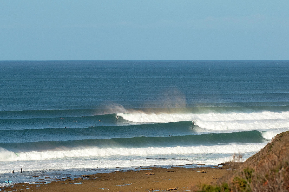
Pumping surf yesterday shot by Judy Scanlon
This week and weekend (Apr 8 - 13)
The strong and significant Southern Ocean frontal progression linked to yesterday’s and today’s swell still has legs, with most of the main activity passing, leaving weaker trailing storms in its wake.
This should provide a slow easing trend over the coming days, with the most significant reinforcing pulse of swell energy due overnight tonight and into tomorrow morning out of the S/SW.
This is a moderate + sized, mid-period swell, generated by a strong fetch of SW winds projecting up and into Tasmania yesterday afternoon and evening.
The Surf Coast should still see surf in the 5ft range tomorrow morning, easing through the day with 6ft+ sets to the east, smaller and down from 3-4ft and 5-6ft respectively west and east of Melbourne Wednesday morning.
Local conditions will be best across the Surf Coast tomorrow morning with a moderate W/NW’ly ahead of relatively weak S/SW winds from about midday, with Wednesday seeing light, local offshore winds early (N/NE to the east and NW to the west, tending W/NW-NW through the morning) ahead of weak mid-afternoon sea breezes.
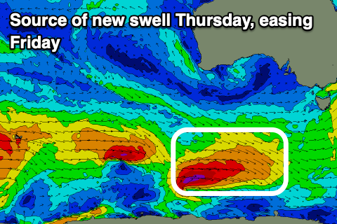
Into Thursday, we’re expecting a good pulse of reinforcing S/SW groundswell, generated by a low that’s currently south of Western Australia, with it forecast to generate a tight but good fetch of gale to severe-gale W’ly winds on the polar shelf.
The swell might not be in at dawn but should be by mid-late morning with the Surf Coast due to build back to 3ft to occasionally 4ft with 5-6ft sets to the east, easing Friday morning from 3ft and 4-5ft+ respectively. Before the swell really gets a chance to drop some new mid-period W/SW swell is expected to be on the build, but firstly looking at the local winds and a moderate, local offshore breeze out of the N’th will favour both coasts Thursday morning.
On Friday, a trough may move through before mid-morning, spoiling the easing swell but early should see NW breezes on the Surf Coast.
Now, this trough will be associated with a healthy frontal progression moving in from the south-west of Western Australia this week, though the strength of the system as a whole has been downgraded since last week.
Instead we’re looking at fun, though only moderate + levels of mid-period W/SW-SW swell into this weekend, with fetch strength mostly falling below gale-force.

The head of the frontal progression looks to generate some initial mid-period W/SW swell through Friday afternoon, while a more favourably aligned fetch of W/SW winds, south of the Bight and in our south-western swell window on Thursday should provide the most size through Saturday.
We’re looking at surf in the 3-5ft range on the Surf Coast with 6ft+ waves to the east on Saturday with N-N/NE winds that might tend N/NW at times on the Surf Coast through the morning, with W/NW tending S winds Sunday as a trough moves through.
As the mid-period energy eases, some longer-range and inconsistent groundswell from the earlier stages of the frontal progression, south of the Indian Ocean is due early next week, though closer-range swell sources may overtake this. More in the next update.
Comments
some of your best work criagos! thanks again
How's the water temp on the Surfcoast fellas?
surfed in a 2/2 steamer on Sunday morning and was warm. helped the sun was out but the wind was blowing hard
Epic - cheers mate. Coming for a quick visit and still in boardies up here, doesn't sound too grim :)
Holy crap, it's pumping right now.
Craigos - long range forey.... WSL getting skunked again?
Will have one by Thursday.
The mid-latitude/troughy pattern isn't ideal. If only it was this week!
And that big arse high setting up between WA and Sth Africa next week looks to be troublesome.
Agreed on troughiness. Had a week of a low sitting over the top of us here. Super unsettled and thundery.
Nice pulse for the after lunch sesh today. What a run it has been.
All models agreeing on a terrible pattern for the start of bells
Yep. Easter looks shite , especially after this week.