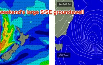
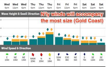
The problem with these kinds of systems is that the greater SE Qld and Far Northern NSW coasts can’t really hand this kind of size, nor the associated gale force E’ly winds.
Primary tabs
/reports/forecaster-notes/south-east-queensland-northern-new-south-wales/2017/10/13/extended-period
thermalben
Friday, 13 October 2017
/reports/forecaster-notes/south-east-queensland-northern-new-south-wales/2017/10/11/not-much-finish
thermalben
Wednesday, 11 October 2017
Sunday is therefore the pick of the weekend, with this short range E/SE swell expected to reach a peak, in addition to a slowly building E’ly swell from a developing trade flow south of New Caledonia - an entirely seperate swell generating system.

/reports/forecaster-notes/south-east-queensland-northern-new-south-wales/2017/10/09/patchy-week-waves
thermalben
Monday, 9 October 2017
The models have really anchored down this broadscale blocking pattern in the latest runs, suggesting a punchy local E'ly swell building through Monday, Tuesday and even holding into Wednesday.

/reports/forecaster-notes/south-east-queensland-northern-new-south-wales/2017/10/06/extended-run
thermalben
Friday, 6 October 2017
The weekend ain’t looking too flash.
/reports/forecaster-notes/south-east-queensland-northern-new-south-wales/2017/10/04/tricky-forecast
thermalben
Wednesday, 4 October 2017
Sunday is the pick of the period because local conditions will also be at their best.

/reports/forecaster-notes/south-east-queensland-northern-new-south-wales/2017/10/02/punchy-ene-swell
thermalben
Monday, 2 October 2017
Model guidance has slightly weakened the developing trough, though we’re still looking at a strong short range E/NE swell peaking on Tuesday before easing on Wednesday.
/reports/forecaster-notes/south-east-queensland-northern-new-south-wales/2017/09/29/drought-breaker
thermalben
Friday, 29 September 2017
Early next week suddenly got a heck of a lot more interesting.
/reports/forecaster-notes/south-east-queensland-northern-new-south-wales/2017/09/27/brief-windows
thermalben
Wednesday, 27 September 2017
The forecast still isn't generally flash. But there are windows of opportunity.
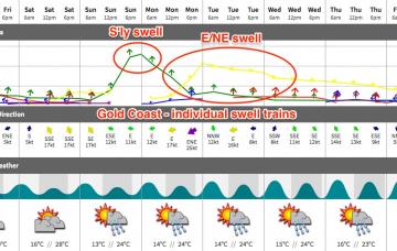
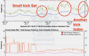
/reports/forecaster-notes/south-east-queensland-northern-new-south-wales/2017/09/25/mixed-bag-ne-and
thermalben
Monday, 25 September 2017
Tuesday looks potentially pretty good, all things considering the last couple of weeks.
/reports/forecaster-notes/south-east-queensland-northern-new-south-wales/2017/09/22/gusty-nly-winds
thermalben
Friday, 22 September 2017
A trough crossing the coast into Monday - linked in with a broad mid-latitude low to the south - will swing winds to the west across the Mid North Coast.