Our next swell comes as the fetch retreats eastwards and becomes intensified by a deepening trough of low pressure between Vanuatu and Fiji, which forms a broad surface which tracks southwards from later this week.
Primary tabs
/reports/forecaster-notes/central-queensland/2024/10/16/small-fun-surf-tailing-e-swell-next-week
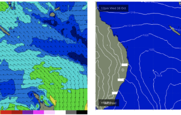
freeride76
Wednesday, 16 October 2024
/reports/forecaster-notes/central-queensland/2024/10/14/small-fun-surf-continues-few-days-yet
freeride76
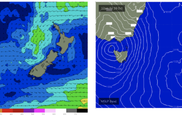
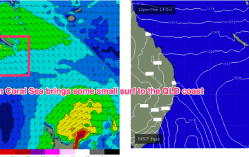
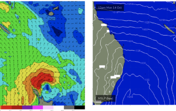
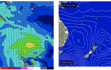
Monday, 14 October 2024
High pressure in the Tasman has maintained a better than expected tradeflow across the Coral Sea focussed SW of New Caledonia. That has seen fun waves across the weekend and we’ll see that surf pattern continue through to Wed at current levels.

/reports/forecaster-notes/central-queensland/2024/10/11/just-breaking-few fun-days-next-week
freeride76
Friday, 11 October 2024
We’ll see surf build on Mon as the next high pressure surge builds and extend into most of next week under SE-E winds.
/reports/forecaster-notes/central-queensland/2024/10/09/tinyflat-surf-continues-over-the-weekend surf
freeride76
Wednesday, 9 October 2024
There is some hope ahead as a new high moves into the Tasman Mon, and builds a ridge up the QLD coast. We should see surf build on Tues as SE winds increase, then maintain a fun sized surf as tradewinds develop through the Coral Sea.
/reports/forecaster-notes/central-queensland/2024/10/07/tinyflat-surf-continues-possible-surf-pattern
freeride76
Monday, 7 October 2024
A stronger high moves through the Bight over the weekend and looks to set-up a SE surge possibly as early as Mon. There is some model divergence leading to low confidence but all major models are suggesting SE winds building through the Coral Sea next week.
/reports/forecaster-notes/central-queensland/2024/09/25/tinyflat-some-minor-surf-next-week
freeride76
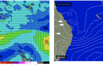
Wednesday, 25 September 2024
As a low sits off the SEQLD Coast over the weekend we’ll see a small signal of E/SE swell develop Sun at exposed spots north the Breaksea spit.
/reports/forecaster-notes/central-queensland/2024/09/23/small-just-rideable-days-ahead-week
freeride76
Monday, 23 September 2024
The strong high is the possible source of surf for CQ and at this stage we’ll see an increase in Coral Sea tradewinds through Tues/Wed, focussed in the Eastern area near New Caledonia. No great size is expected but we should see some tiny just rideable surf through Tues-Thurs on low tides.
/reports/forecaster-notes/central-queensland/2024/09/20/tinyflat-weekend-surf-developing-mid-next
freeride76
Friday, 20 September 2024
Tradewinds are expected to develop in the Coral Sea through next week, leading to rideable surf from mid week.
/reports/forecaster-notes/central-queensland/2024/09/18/becoming-tiny-some-surfable-days-next-week
freeride76
Wednesday, 18 September 2024
The next high pressure ridge will build in on Tues next week and if current modelling holds we should see weak but persistent tradewinds develop in the Coral Sea mid next week with small but rideable surf developing Wed or Thurs.
/reports/forecaster-notes/central-queensland/2024/09/16/surfable-days-easing-the-mid-week
freeride76
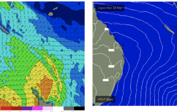
Monday, 16 September 2024
The current SE surge from the high has produced more surfable conditions across CQ, which will ease into the middle of this week.