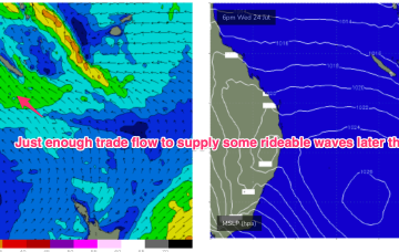
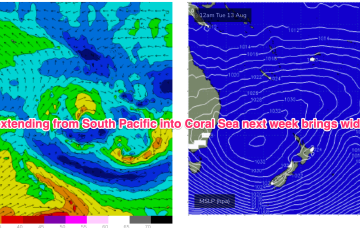
High pressure systems are looking weak and mobile as befits the changing seasons, tracking NE into the Tasman and bringing a N’ly flow across sub-tropical to temperate regions but holding enough strength in the Coral Sea to generate some small rideable waves from mid-week.
Primary tabs
/reports/forecaster-notes/central-queensland/2024/08/19/tiny-start-becoming-rideable-mid-week
freeride76
Monday, 19 August 2024
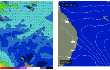
/reports/forecaster-notes/central-queensland/2024/08/16/surf-easing-over-the-weekend-becoming-tiny
freeride76
Friday, 16 August 2024
Our summer-style swell producing pattern has broken down and we’re seeing surf ease into the weekend, becoming tiny into next week as high pressure moves towards Tasmania.
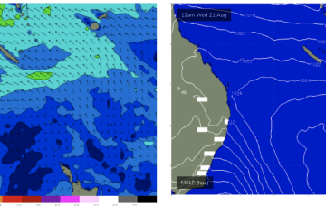
/reports/forecaster-notes/central-queensland/2024/08/14/pumping-surf-easing-the-weekend
freeride76
Wednesday, 14 August 2024
A summer style pattern is seeing tropical moisture dragged down the East coast by a trough and deep E/NE-NE flow from a large high in the Tasman, generating large swells for Central QLD.
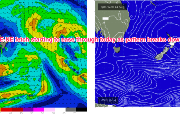
/reports/forecaster-notes/central-queensland/2024/08/12/solid-onshore-surf-good-part-week
freeride76
Monday, 12 August 2024
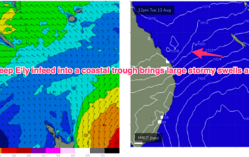
We have a strong (1033hPa) high in the Tasman, with a deep E’ly flow through the Coral Sea feeding into a coastal trough along the QLD coast. That trough is drawing down plenty of tropical moisture in the deep onshore flow, and generating sizey, stormy E’ly swells for the sub-tropics.
/reports/forecaster-notes/central-queensland/2024/08/09/out-season-pumping-surf-next-week
freeride76
Friday, 9 August 2024
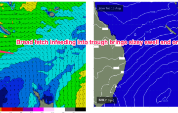
No change expected to the broad pattern next week with strong high pressure moving into the Tasman and a broad, deep E’ly fetch developing through the Coral Sea, with an embedded trough.
/reports/forecaster-notes/central-queensland/2024/08/07/pumping-surf-next-week
freeride76
Wednesday, 7 August 2024
No change to the broad pattern expected next week which is strong high pressure in the Tasman and and deep E’ly fetch developing.
/reports/forecaster-notes/central-queensland/2024/08/05/extended-surf-pattern-ahead-weekend
freeride76
Monday, 5 August 2024
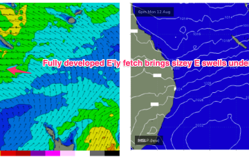
Into the mid next week and we should see some real size about as the persistent E’ly winds generate a fully developed sea state through our near swell window.
/reports/forecaster-notes/central-queensland/2024/07/26/tiny-waves-week-easing-possible-surf-days
freeride76
Friday, 26 July 2024
SE winds have supplied some just rideable surf through today.

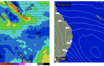
/reports/forecaster-notes/central-queensland/2024/07/24/small-fun-waves-the-weekend
freeride76
Wednesday, 24 July 2024
Lovely settled conditions at the moment with a broad area of high pressure in the Tasman and a broad but weak tradewind fetch just moving into a better position S and SW of New Caledonia. That will see some small E/NE swell develop through the end of this week into the weekend.
/reports/forecaster-notes/central-queensland/2024/07/22/small-rideable-surf-mid-week
freeride76
Monday, 22 July 2024
Central QLD Forecaster Notes by Steve Shearer (updated on Mon July 22nd)
This week and next week (July22-Aug 2)
Central QLD: Small, rideable surf from mid week
Nothing over the weekend and into today.