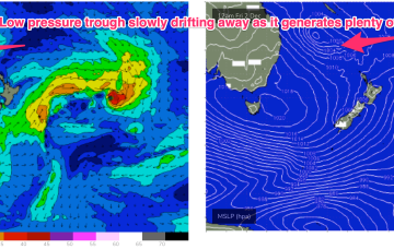
A slow moving low pressure system is currently off the QLD coast generating plenty of size for the subtropics. Windspeeds along the southern flank are just a notch higher than modelled on Wed so we’ve seen a corresponding uptick in size.
Primary tabs
/reports/forecaster-notes/south-east-queensland-northern-new-south-wales/2022/12/02/pumping-point
freeride76
Friday, 2 December 2022

/reports/forecaster-notes/south-east-queensland-northern-new-south-wales/2022/11/30/lots-action-ahead
freeride76
Wednesday, 30 November 2022
We are seeing the “schizoid” pattern now develop whereby a monsoonal trough is splitting off a low pressure trough along the CQ coast, supported by a high pressure belt from the Bight to the Tasman Sea, while fronts and a parent low are entering the lower Tasman. That is seeing a regime where both S swells and a developing E’ly swell event are both in play across most of the Eastern Seaboard.
/reports/forecaster-notes/south-east-queensland-northern-new-south-wales/2022/11/28/juicy-looking
freeride76
Monday, 28 November 2022
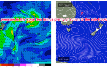
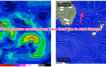
We’ve got an interesting looking pattern as we transition into Summer, with both active frontal systems transiting below the continent and a precursor monsoonal trough across the top end of Australia. A front pushing into the Tasman Sea and a deeper parent low bring S swell pulses this week while a trough of low pressure is expected to hive off the precursor monsoon trough mid week and sit in the Coral Sea later this week, bringing plenty of E swell for the Eastern Seaboard- especially favouring the sub-tropics for size and duration.
/reports/forecaster-notes/south-east-queensland-northern-new-south-wales/2022/11/25/coral-sea-fires
freeride76
Friday, 25 November 2022
The more intense action will be in the sub-tropics with potential for a trough of low pressure to form off the CQ coast, potentially deepening into a hybrid sub-tropical low later next week. That looks to generate large swells for the SEQLD/NENSW Points for the most part.
/reports/forecaster-notes/south-east-queensland-northern-new-south-wales/2022/11/23/stronger-s-swell
freeride76
Wednesday, 23 November 2022
It now looks like we are seeing more action start up from the tropics with a cross-equatorial surge and monsoonal flow across Northern Australia into the Coral Sea. Vorticity along this surge and trough line may see low pressure develop in our swell window later next week.

/reports/forecaster-notes/south-east-queensland-northern-new-south-wales/2022/11/21/another-week-s
freeride76
Monday, 21 November 2022
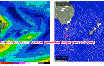
Todays W’ly change was the herald for a strong frontal progression which is currently unfolding at the gateway to the Tasman Sea. We have a front tied to a small low E of Tasmania with a much deeper parent low well to the south of Tasmania. There are multiple swell generating fetches associated with this complex low arrangement, favouring NENSW S swell magnets for size.
/reports/forecaster-notes/south-east-queensland-northern-new-south-wales/2022/11/18/strong-nlies-over
Strong N'lies over the weekend as S swell eases with another round of overlapping S swells next week
freeride76
Friday, 18 November 2022
We’re past the peak of the current S swell event as the large low pressure system drifts towards New Zealand, weakening as it does so and a more mobile high pressure system moves north-east into the Tasman Sea, bringing N’ly winds.
/reports/forecaster-notes/south-east-queensland-northern-new-south-wales/2022/11/16/s-swells
freeride76
Wednesday, 16 November 2022
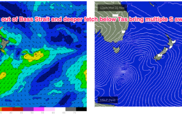
The low east of Tasmania moves NE and joins other areas of troughy low pressure to form a large low pressure gyre which occupies most of the Tasman Sea through the latter part of this week. Surf size will be limited by the relatively weak supporting high pressure cell which is currently tracking through the Bight. We’re still looking at plenty of moderate size surf from the S quadrant to end the week and carry through into the start of the weekend.
/reports/forecaster-notes/south-east-queensland-northern-new-south-wales/2022/11/14/plenty-wind
freeride76
Monday, 14 November 2022
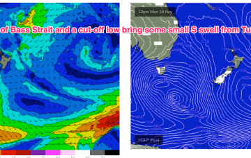
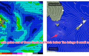
Through the early part of this week the low slips SE of Tas and a complex, troughy pattern with multiple low centres sits in the Tasman. This complex low pressure area eventually gets squeezed by an oncoming high generating fresh S’lies and which overlap with deeper S’ly fetches to create a series of S swells later this week.
/reports/forecaster-notes/south-east-queensland-northern-new-south-wales/2022/11/11/spring-conditions
freeride76
Friday, 11 November 2022
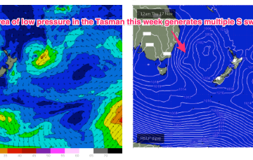
We’re looking at a complicated synoptic set-up from Wed next week with multiple small low pressure troughs off the NSW Coast and the remnants of a cut-off low which tracks SE into the Tasman as it weakens.