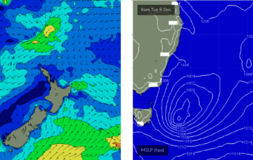
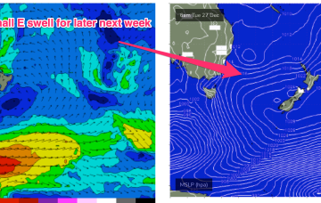
We’re now on the cusp of a dynamic, tropical induced blocking pattern with low pressure hiving off an active monsoon trough in the Coral Sea and meandering in Coral Sea before drifting down into the Northern Tasman. The high pressure belt holds good support for this low pressure area with reinforcing cells stacking onto a slow moving system located at South Island latitudes. This will see an extended E’ly swell event, with days of pumping E swell ahead.
Primary tabs
/reports/forecaster-notes/south-east-queensland-northern-new-south-wales/2022/12/26/classic-monsoonal
freeride76
Monday, 26 December 2022
/reports/forecaster-notes/south-east-queensland-northern-new-south-wales/2022/12/23/tiny-over-the
freeride76
Friday, 23 December 2022
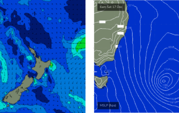
The broad pattern will be setting up by Boxing Day with a dominant, slow moving high in the Tasman and low pressure expected to form along the monsoon trough line in the Coral Sea and in the South Pacific near the North Island. That will see at least dual swell producing fetches aimed at the Eastern Seaboard, favouring our subtropical region for most size.
/reports/forecaster-notes/south-east-queensland-northern-new-south-wales/2022/12/21/not-much-xmas
freeride76
Wednesday, 21 December 2022
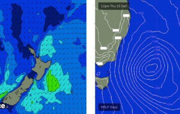
Models are now firming on a trough of low pressure forming near the North Island early next week and retrograding in a SW direction back towards the Eastern seaboard
/reports/forecaster-notes/south-east-queensland-northern-new-south-wales/2022/12/19/couple-more-days
freeride76
Monday, 19 December 2022
The combination of a Tasman low and strong high moving through the Bight has supplied a stack of S swell to the f/cast region since late last week, with an intensification and N’ward movement of the low upping the size and local winds through today on the MNC, and across the rest of the region through tomorrow. Pressure gradients will now slowly ease as the low starts to dissipate and the strong high weakens as it moves South of Tasmania through tomorrow.
/reports/forecaster-notes/south-east-queensland-northern-new-south-wales/2022/12/16/stacks-sustained
thermalben
Friday, 16 December 2022
There's no evidence to suggests any deviation away from the current regional trend for the east swell.
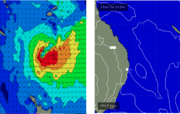
/reports/forecaster-notes/south-east-queensland-northern-new-south-wales/2022/12/14/long-run-swell
thermalben
Wednesday, 14 December 2022
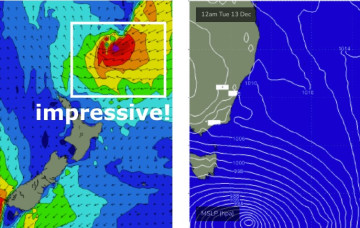
The main synoptic feature for the short term period is a developing complex Tasman Low that'll spin up east of Bass Strait overnight, and reach peak intensity on Friday, but actually remain active within our swell window until next Wednesday.
/reports/forecaster-notes/south-east-queensland-northern-new-south-wales/2022/12/12/active-period-the
thermalben
Monday, 12 December 2022
Lots of swell due this weekend from both the Tasman Low, and the sub-tropical low south of Fiji. But we'll see good waves prior to then too.

/reports/forecaster-notes/south-east-queensland-northern-new-south-wales/2022/12/09/solid-weekend
thermalben
Friday, 9 December 2022
A deepening Tasman Low is currently parked midway between Tasmania and New Zealand, and southerly gales around its western flank reached maximum strength around lunchtime today.
/reports/forecaster-notes/south-east-queensland-northern-new-south-wales/2022/12/07/solid-round-south
thermalben
Wednesday, 7 December 2022
On Thursday and Friday, a new Tasman Low will develop off the Southern NSW Coast and move slowly eastwards. The latest model runs have strengthened this low, broadened its fetch and slowed its eastwards track.
/reports/forecaster-notes/south-east-queensland-northern-new-south-wales/2022/12/05/easterly-window
thermalben
Monday, 5 December 2022
Plenty of fun surf this weekend. For Northern NSW, that is.