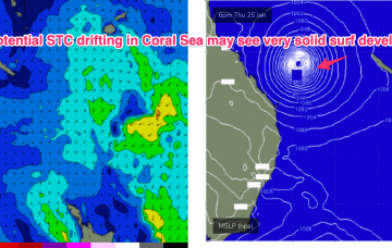
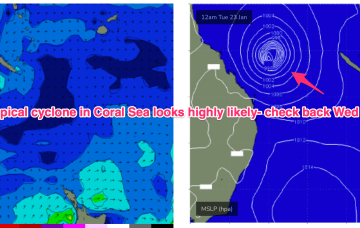
All eyes on the Coral Sea where this tropical low is expected to deepen into a tropical cyclone that is expected to be slow moving.
Primary tabs
/reports/forecaster-notes/central-queensland/2024/01/19/cyclone-swell-likely-next-week
freeride76
Friday, 19 January 2024
/reports/forecaster-notes/central-queensland/2024/01/17/small-in-the-short-run-probable-cyclone-in
freeride76
Wednesday, 17 January 2024
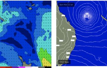
In the South Pacific we have a retrograding trough of low pressure along a tradewind band and finally,the Northern Australian Monsoon (NAM) is in full swing and a tropical low is expected to bud off the end of the monsoon trough into and over the weekend, with a reasonable likelihood of cyclogenesis into next week. Still plenty of uncertainty there over intensity, track and surf potential but at least some model runs are starting to look favourable.
/reports/forecaster-notes/central-queensland/2024/01/15/small-in-the-short-run-possible-cyclone-in
freeride76
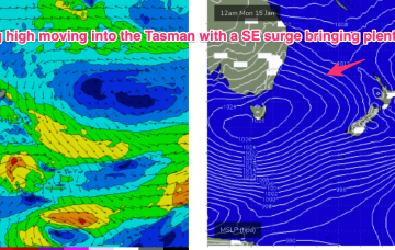
Monday, 15 January 2024
A SE surge currently working it’s way north now looks to stall and dissipate before it reaches water north of Fraser Island with only tiny/small surf expected for CQ.
/reports/forecaster-notes/central-queensland/2024/01/12/much-better-outlook-finally- -surf-days-ahead
freeride76
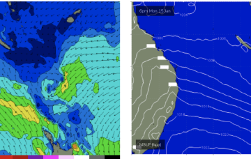
Friday, 12 January 2024
The resulting SE surge up through the Tasman into the Coral Sea generates plenty of swell as the fetch spreads out across the Tasman. We should see surf build Tues into Wed with plenty of fun surf.
/reports/forecaster-notes/central-queensland/2024/01/10/minor-se-surge-week-brings-some-small-surf
freeride76
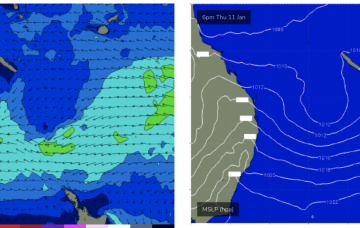
Wednesday, 10 January 2024
A large high SE of the South Island (1034 hPa) interacting with a broad low pressure trough in the South Pacific which will supply E’ly quadrant swell in the near term as the low pressure trough retrogrades back towards the east coast and a SE surge develops up the QLD coast.
/reports/forecaster-notes/central-queensland/2024/01/08/small-bits-and-pieces-short-term-longer-term
freeride76
Monday, 8 January 2024
Easterly swells will favour the sub-tropics for size with the CQ region seeing small swells later this week as the fetch is on the edge of the swell window. Longer term is starting to look very active as well.
/reports/forecaster-notes/central-queensland/2024/01/05/some-small-surf-now-the-radar-nothing
freeride76
Friday, 5 January 2024
Not a great deal of change to the weekend f/cast other than the current SE surge lifting wave heights a notch into Sun as winds freshen through the Wide Bay/CQ region.
/reports/forecaster-notes/central-queensland/2024/01/03/still-tiny-just-breaking-low-tides-flat-spell
freeride76
Wednesday, 3 January 2024
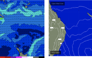
A trough moving north from a position east of Tasmania brings a renewal of the S’ly pattern into Fri but not extending into the Coral Sea due to another troughy area in the Northern Tasman which confines E’ly winds to below the CQ swell window.
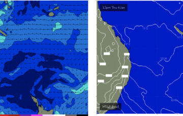
/reports/forecaster-notes/central-queensland/2024/01/01/nothing-significant-ahead-some-marginal
freeride76
Monday, 1 January 2024
The high in the Tasman sets up some sort of trade flow in the Coral Sea later this week and into the next. It’s not much of a fetch, mostly weak, disjointed and located at the extremity of the Coral Sea (close to New Caledonia) but it should be enough too see some just rideable surf for late this week.
/reports/forecaster-notes/central-queensland/2023/12/29/still-looking-the-end-the-flat-spell-coral
freeride76
Friday, 29 December 2023
No change to the outlook with a lifeless Coral Sea and very weak pressure gradients leading to very light winds in the CQ swell window and more tiny/flat surf over the weekend.