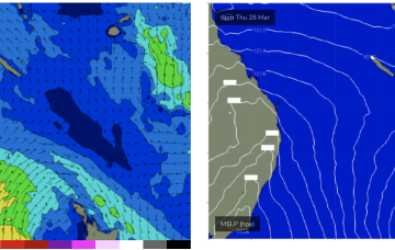
Weak but persistent tradewinds in the Coral Sea should hold surf just rideable on low tides. If the retrograding low comes off as modelled we’ll see a nice boost in size from Fri into the weekend.
Primary tabs
/reports/forecaster-notes/central-queensland/2024/04/01/just-surfable-week-nice-boost-possible-the
freeride76
Monday, 1 April 2024
/reports/forecaster-notes/central-queensland/2024/03/29/fun-surf-continues-easter-easing-back-later
freeride76
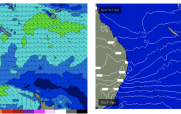
Friday, 29 March 2024
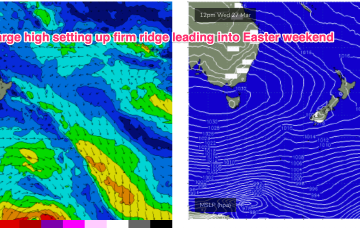
High pressure in the Tasman is maintaining a ridge along the QLD coast with fun sized surf across the CQ region under mod/fresh SE winds.
/reports/forecaster-notes/central-queensland/2024/03/25/tiny-just-rideable-days-ahead-boost-in-size
freeride76
Monday, 25 March 2024
The tradewind belt is weak but perisistent enough to produce some just rideable surf across CQ on the right tides.
/reports/forecaster-notes/central-queensland/2024/03/22/easing-swells-over-the-weekend-some-tiny-days
freeride76
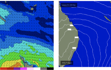
Friday, 22 March 2024
Weak high pressure in the Tasman is seeing a dissipating tradewind fetch in the Coral Sea so we’ll finally see this run of surf wind down over the weekend, becoming tiny likely by Sat a’noon into Sun.
/reports/forecaster-notes/central-queensland/2024/03/20/surf-keeps-coming
freeride76
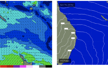
Wednesday, 20 March 2024
Into next week and we’ll see a new high pressure system set up a SE surge as we move into the Easter weekend.
/reports/forecaster-notes/central-queensland/2024/03/18/fun-waves-keep-coming-most-week-and-next-week
freeride76
Monday, 18 March 2024
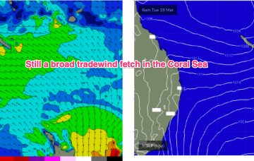
Pretty typical late Summer pattern with a high in the Tasman and a maturing trade-wind flow in the Coral Sea, linked to an active monsoon trough with a small embedded low in the Coral Sea. There is a tropical cyclone in the Gulf of Carpentaria which formed over the weekend but this system is expected to track inland over the NT and Kimberley regions and not be a swell source for the East Coast.
/reports/forecaster-notes/central-queensland/2024/03/13/surf-easing-then-rebuilding-over-the-weekend
freeride76
Wednesday, 13 March 2024
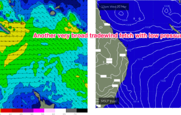
We’ve still got a broad trade wind flow in the Coral Sea, extending out into the South Pacific and anchored head and tail by low pressure along the monsoon trough. That’s producing plenty of surf in the sub-tropics although we’ll now see a slow easing trend into the end of the week.
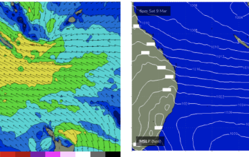
/reports/forecaster-notes/central-queensland/2024/03/08/days-more-solid surf-come
freeride76
Friday, 8 March 2024
We’ve still got our late Summer pattern next week with high pressure straddling New Zealand, a monsoon trough strung across Northern Australia extending into the South Pacific and a long, broad tradewind fetch between the two broadscale atmospheric features.
/reports/forecaster-notes/central-queensland/2024/03/06/plenty-waves-tap-week-and-next
freeride76
Wednesday, 6 March 2024
We currently have a weaker cell in the Tasman, with a much stronger cell entering the Bight. This dominant high pressure belt will set up a long, broad tradewind fetch through the Coral Sea, extending at times into the Northern Tasman and South Pacific.
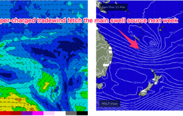
/reports/forecaster-notes/central-queensland/2024/03/04/extended-run-surf-ahead
freeride76
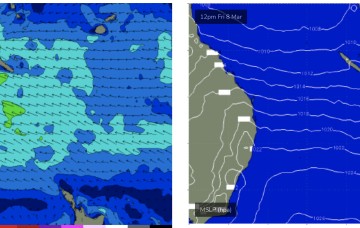
Monday, 4 March 2024
We should see rideable surf develop through Wed as a SE surge builds across the region and extends out into the Coral Sea.