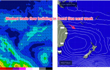
We currently have a weaker cell in the Tasman, with a much stronger cell entering the Bight. This dominant high pressure belt will set up a long, broad tradewind fetch through the Coral Sea, extending at times into the Northern Tasman and South Pacific.
Primary tabs
/reports/forecaster-notes/central-queensland/2024/03/06/plenty-waves-tap-week-and-next
freeride76
Wednesday, 6 March 2024
/reports/forecaster-notes/central-queensland/2024/03/04/extended-run-surf-ahead
freeride76
Monday, 4 March 2024
We should see rideable surf develop through Wed as a SE surge builds across the region and extends out into the Coral Sea.
/reports/forecaster-notes/central-queensland/2024/03/01/small-trade-swell next-week
freeride76
Friday, 1 March 2024
Tradewinds start to thicken up from the Coral Sea into the Northern Tasman so we should see some E/SE swell start to build, possibly as early as Thurs.
/reports/forecaster-notes/central-queensland/2024/02/28/tiny surf-while-small-trade-swell next-week
freeride76
Wednesday, 28 February 2024
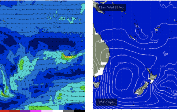
We’ll see a new high move into the Tasman next week with healthier looking tradewind flow in the Coral Sea.

/reports/forecaster-notes/central-queensland/2024/02/26/tinyflat-surf-while-hope-the-horizon-next
freeride76
Monday, 26 February 2024
Further ahead and we should see high pressure become slow moving in the Tasman next week. A moderate trade-flow looks to set up in the Coral Sea, with workable trade-wind swells across CQ for the second half of next week. Either way, nothing dramatic in the tropics on the radar, so we’ll come back Wed and see how it’s looking.
/reports/forecaster-notes/central-queensland/2024/02/23/run-fun-waves-coming-end
freeride76
Friday, 23 February 2024
Not much else on the radar after that- looks like a very quiet start to Autumn with some small/tiny days to end next week and enter the first weekend of March.
/reports/forecaster-notes/central-queensland/2024/02/16/plenty-small-surfable-days-ahead
freeride76
Friday, 16 February 2024
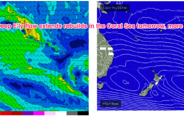
E’ly winds continue into next week, through this period and in fact most of next week we’ll continue to see pulsey E’ly swells coming off the deep E’ly fetch.
/reports/forecaster-notes/central-queensland/2024/02/14/more-surf-tap-bigger-the-weekend
freeride76
Wednesday, 14 February 2024
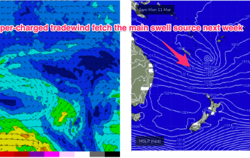
Multiple cells of reinforcing high pressure then one by one move into the Tasman, maintaining a weak ridge up the NSW Coast and a deep E’ly flow through the South Pacific and Eastern Coral Sea, with resulting E’ly swells favouring the sub-tropics for size, with a rebuild in size expected later this week.
/reports/forecaster-notes/central-queensland/2024/02/12/few-ups-and-downs-surfable-most-days
freeride76
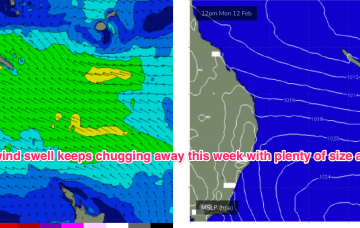
Monday, 12 February 2024
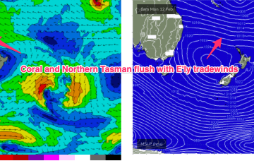
Large high in the Tasman directing plenty of E’ly-SE’ly tradewinds through the Coral Sea and South Pacific slot. Typical summer wind pattern with E-E/SE winds in the sub-tropics.
/reports/forecaster-notes/central-queensland/2024/02/09/surf-pattern-continues-through-next-week
freeride76
Friday, 9 February 2024
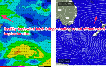
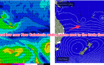
The E’ly-SE’ly fetch gets reinforced later Sat by a new high pressure ridge squeezing up against a tropical low hovering NW of New Caledonia so we should see surf start to build again through Sun.